The ways an urban neighborhood is built and the characteristics of the people who live there are both related to how hot it gets. That is the result of our study, published by the Journal of Buildings.
If you have ever noticed that some parts of a city feel significantly hotter than others, you have experienced a phenomenon known as the urban heat island effect. This effect is most noticeable at night and when comparing rural and suburban surroundings with urban ones.
How we did our work
Our interdisciplinary group of researchers studied two Philadelphia census tracts and found a clear link between outdoor temperature and specific urban characteristics. We then asked whether these urban characteristics can be related to the social vulnerability of the residents.
Social vulnerability is a concept that goes beyond the residents’ income to include housing conditions and characteristics of the people – such as their age, education, disability and race. Our social vulnerability index data was created using 16 U.S. census variables.
The design elements of cities, from the materials used for streets and sidewalks to the size and placement of buildings, significantly affect urban heat. To gain a deeper understanding of these impacts, we conducted computer simulations of outdoor air temperature and comfort levels in two Philadelphia census tracts with distinct indices for social vulnerability, one in Roxborough and the other in South Philadelphia.
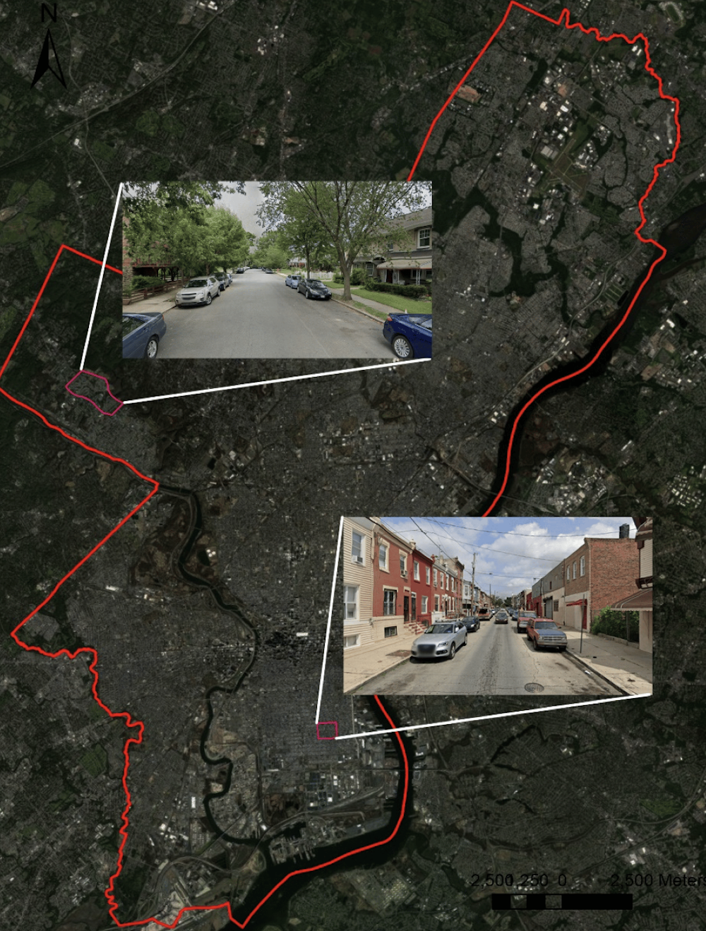
The social vulnerability index shows a number from 0 to 1, with higher numbers meaning more vulnerable. Our neighborhood in Roxborough had a number of 0.25. In South Philadelphia, the number was 0.98.

Using the open-source geographic information system, or GIS, that analyzes maps, along with a microclimate simulation tool, we found that the South Philadelphia neighborhood had more absorbing surfaces such as concrete. Greenery, including trees and grass, was notably lacking in this neighborhood compared with Roxborough. The characteristics contributed to elevated levels of heat and consequently higher reported levels of discomfort in this neighborhood.
Trees are superheroes for cooling down urban areas. Tree crowns block the Sun’s rays and provide shade. In addition, they release moisture through evapotranspiration – cooling the surroundings even more.
Our study found that during hot and extremely hot conditions, areas with more trees had up to 1.5 degrees Celsius (2.7 degrees Fahrenheit) lower outdoor air temperatures compared with less green areas. Therefore, fewer trees and more paved surfaces, associated with the high social vulnerability neighborhood, meant higher heat exposure and less outdoor comfort for residents.
Similar results were found in 2021 by researchers at Guangxi University in China who investigated solar radiation reduction using favorable design factors on an urban block in the city of Nanning.
In addition to material surfaces and vegetation, our study delved into other urban characteristics that can affect heat. One such aspect is the sky view factor, which measures the amount of sky visible from the ground. In areas with more sky exposure, we observed increased heat.
The ratio between the building height and street width also plays a critical role. This ratio determines how much shade is provided by buildings, with taller buildings and narrower streets offering more shade and cooler temperatures. However, the two Philadelphia neighborhoods were influenced by unique street layouts and architectural designs regardless of their socioeconomic status. The census tract we studied in South Philadelphia features low-rise brick townhouses common in the city. In Roxborough, the neighborhood is more suburban, with detached single-family houses with pitched roofs and front lawns.
Why it matters
Our findings from Philadelphia show that urban design, material choices and tree coverage significantly affect how warm or cool an area feels.
This suggests that thoughtful planning and incorporating more greenery can make urban areas more livable and equitable. Architects can help by using lighter-colored materials and green walls and roofs.
Guangqing Chi receives funding from the National Science Foundation.
Lisa D. Iulo receives funding from U.S. Department of Energy. https://ess.science.energy.gov/urban-ifls/bsec-uifl/
Farzad Hashemi and Ute Poerschke do not work for, consult, own shares in or receive funding from any company or organisation that would benefit from this article, and have disclosed no relevant affiliations beyond their academic appointment.
This article was originally published on The Conversation. Read the original article.