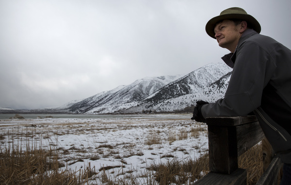
MAMMOTH LAKES, Calif. _ The first band of what forecasters predict will be the region's most powerful storm in a decade moved into Northern California on Saturday, prompting official warnings of widespread flooding and epic snowfall.
"People are definitely in a state of panic right now," said El Dorado County Sheriff's Sgt. Todd Hammitt. "We're getting a lot of calls asking if we're going to be able to deal with everything. It's the general pandemonium of not knowing what's coming."
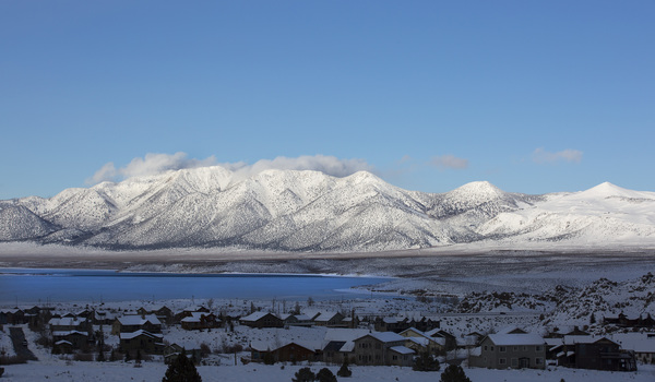
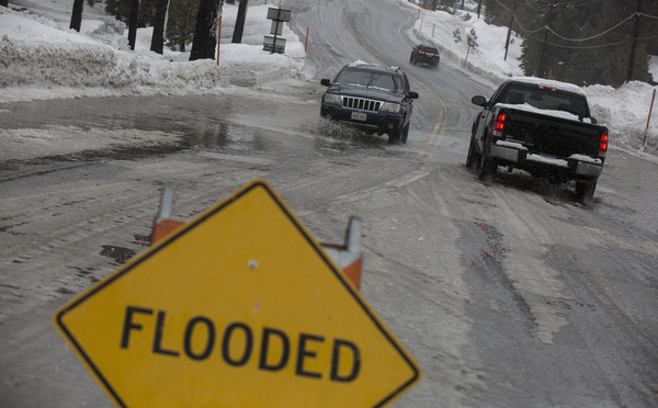
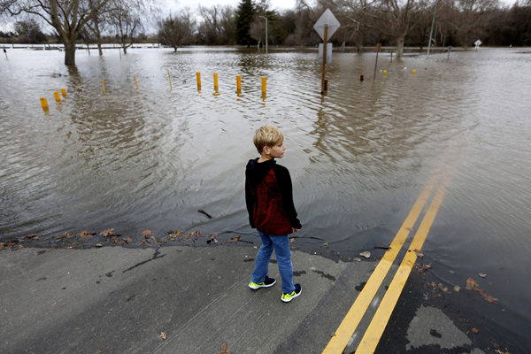
The epic system _ known as an atmospheric river _ could dump so much rain and snow that some ski runs and roads will be declared off-limits, with forecasters warning of significant flooding, mudslides and avalanches in the Sierra Nevada.
Up to 12 inches of rain is expected to fall on areas below 8,500 feet beginning Saturday morning, and up to 7 feet of snow could bury higher elevations, according to the National Weather Service. Forecasters said the storm was packing the same wallop as one that hit Northern California in 2005, causing $300 million in damage.
This weekend's system could bring 36 consecutive hours of heavy rain from Mammoth Mountain to Susanville, in Lassen County. Although that is good news for California, which is entering its sixth year of drought, the coming rain could melt already standing snow _ feeding watersheds swollen from storms earlier this week, forecasters said.
"It's going to be a busy weekend," said Edan Weishahn, a meteorologist with the National Weather Service in Reno, sighing.
The rain moved in late Friday and continued into Saturday morning, with the most powerful punch expected later in the day.
In the eastern Sierra Nevada, snow continued to fall at higher elevations while rain drizzled lower down as officials warned that wetter, rainier conditions on tap for later this weekend could spell trouble.
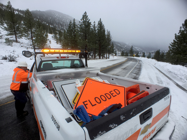
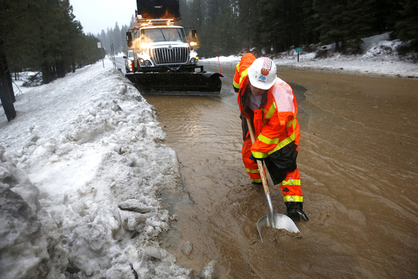
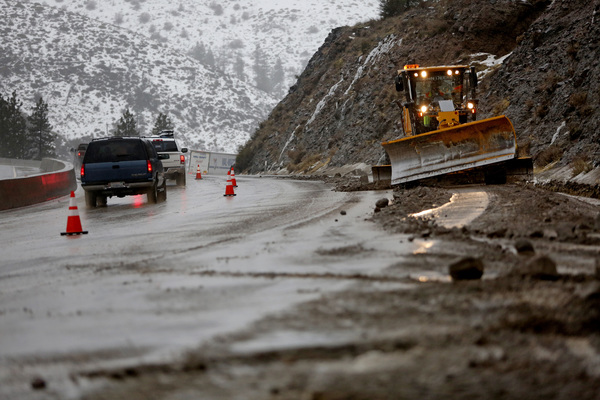
Officials toiling to keep highways clear said they were concerned about a warmer phase of the storm that could fall as rain even at higher elevations, melting the built-up snow and unleashing mudslides, flooding and avalanches.
"It's the rain over the snow that we're worried about," said Greg Miller, a Caltrans maintenance manager. "We've had snow since Christmas, but now with the warmer trend, we're worried about water."
With storm drains frozen, he said, an influx of rain could send water and mud into roadways.
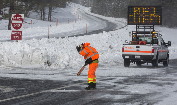
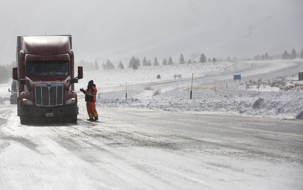
Miller said crews were taking special precautions to prevent rockslides from a segment of U.S. 395 near Lee Vining and avalanches from several other critical transportation corridors.
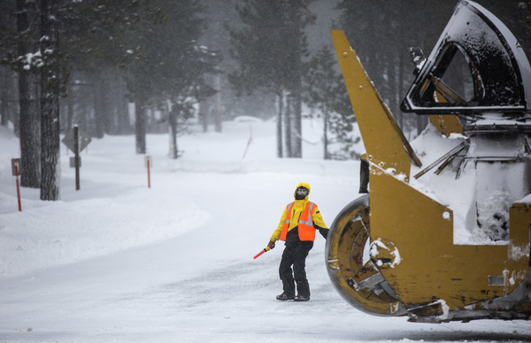
Friday morning, Caltrans closed part of California 120 near June Lake while a crew set out off remotely detonated charges to clear avalanche-prone slopes of accumulating snow.
Crews were plowing, sanding and blowing snow from roadways around the clock in 12-hour shifts, Miller said.
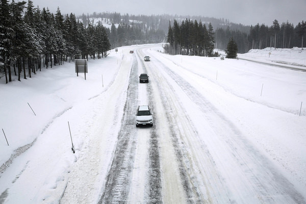
The California Highway Patrol responded to several reports of rolled-over vehicles and other snow-related collisions on U.S. 395.
Tire chain restrictions were in effect across much of the Sierra Nevada.
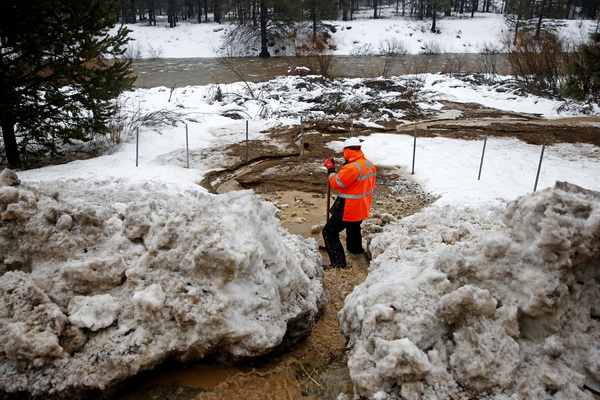
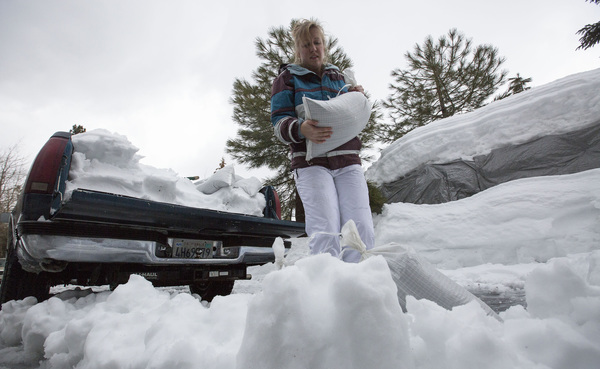
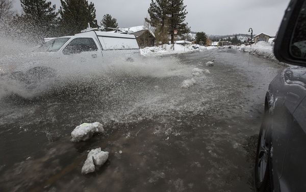
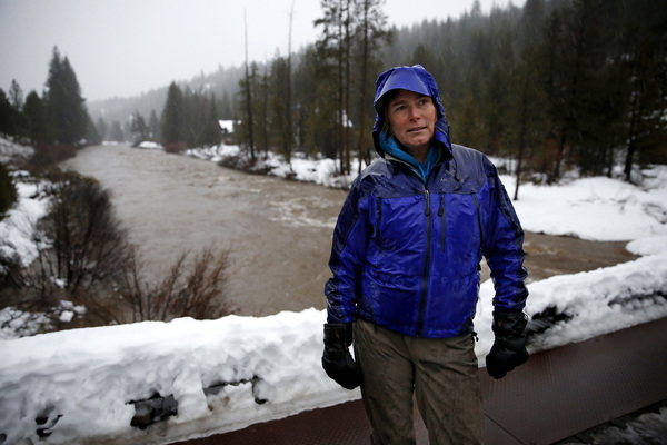
Residents in Mammoth Lakes are concerned that warm rain and slush will dam up behind banks of shoveled snow piled high in empty lots and along roads throughout town, then flow wherever it can find a path, clogging existing drainage systems with debris and ice.
"In this town, we don't even have rain gutters because they get ripped down by snow," said Lisa Isaacs, a resident and environmental activist. "So, we're very worried that this storm will flood homes and garages."
The National Weather Service issued a flood watch warning for Sunday, and town officials advised residents to stock up on water, food, first aid supplies, clothing and bedding, tools and emergency supplies, along with special items for medical conditions.
On a winter war footing, Mammoth Lakes residents lined up throughout the day on Saturday at the town's utility yard to load up on 40-pound sandbags they hoped would steer waves of slush away from homes, ground-floor condominiums and businesses.
Among them were Mammoth Lakes residents Greg Newbry, 66, a recently retired Mono County employee, and his wife, Linda Salcido, 67, Mono County's director of public health.
"I was here in 1982 when this town was wrecked by massive flooding," Newbry recalled. "Main Street was under 2 feet of water. Businesses closed. The roofs of five mobile homes collapsed under the weight of rain on snow.
"If we get all the rain predicted in the forecasts," he added, "every slab of concrete at ground level is vulnerable, and we live in a ground-floor condominium."
As she helped tote 20 sandbags to their vehicle, Salcido said she was concerned about the potential effects of flooding countywide.

"Snow, even lots and lots of it, we can handle," she said. "But a major flood event would lead to countless challenges."
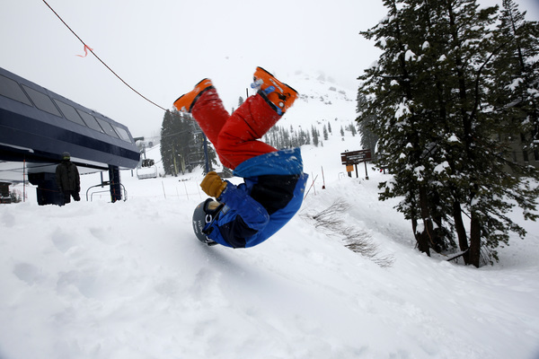
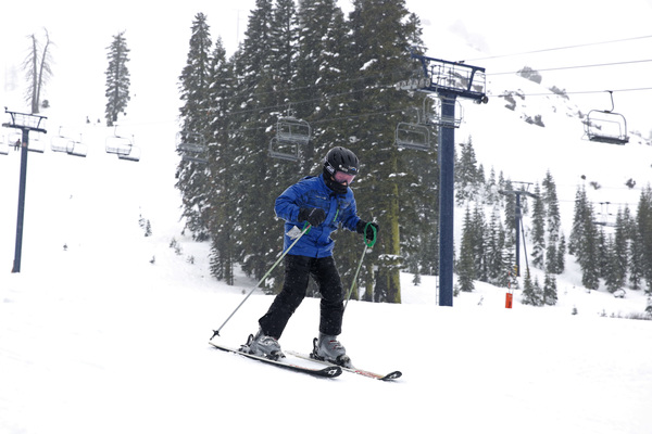
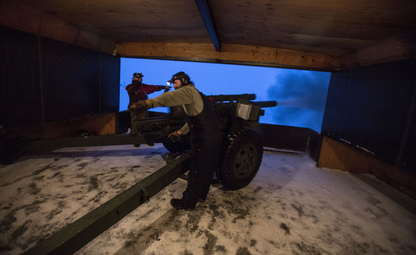
Up on Mammoth Mountain, the mood was more upbeat as thousands of skiers and snowboarders raced down slopes that had received as much as 80 inches of snow over the last week alone.
Rising 11,000 feet from a gap in the Sierra Nevada range, Mammoth Mountain's steep chutes stand in the path of freshly brewed atmospheric river systems. With relatively low mountains to the west of it, Mammoth receives most of their unspent snow.
But big snowfall, high winds, warm rain and rising temperatures are forces that transform pile powder into unstable clumps that set off avalanches. So Mammoth Mountain Resort specialists were bringing snowpacks down with artillery including howitzers.
Down in Mammoth Lakes, Isaacs spent Saturday hoping that "the rain they keep talking about will turn out to be snow."
"But it'll probably be like having a giant fire big hose turned on us and we'll be swamped," she said with a nervous laugh. "I just hope that my little $150 water pump can keep with it."
Mammoth Mountain Chief Executive Rusty Gregory had few answers. "The main topic of conversation over cocktails on Sunday night," he mused, "will be about what actually happened."
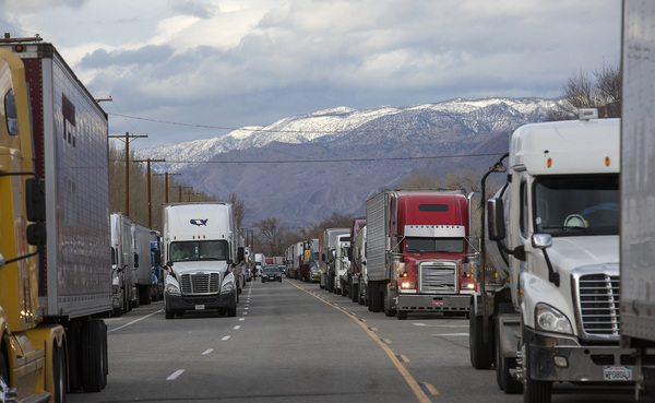
The storm was also bringing wind gusts that topped 50 mph. Officials said they were low snow and icy conditions on Interstate 5 and 80 as well as U.S. 50 and some mountain highways.
The National Weather Service on Saturday morning released a new timeline for the storms moving through the region:
Saturday: Moderate to heavy snow in mountain areas.
Sunday: Heaviest rain and snow, with risks of flooding.
Monday: Showers and snow continue, with continued flood risk.
Tuesday: New storm moves in, lower snow levels, flood risk.
Wednesday: Showers and snow, with rivers running high.
"We're expecting heavy, heavy rain. It starts out as snow then turns to rain then turns to snow again," Hammitt said. "We're concerned about the melt increasing waterways and all the lakes."
Hammitt recalled storms in 1997 and 2005 when runoff overwhelmed local rivers and creeks and sent water into roads and homes, lifting some buildings off their foundations.
"We have streams, creeks, rivers. We have lakes and ponds," Hammitt said. "Anybody near a water source could be in jeopardy depending on the severity of the storm."
Two sinkholes have been reported on El Dorado County roads as a result of three days of rain this week. Residents have already filled 12,000 sandbags in preparation for the storm and an additional 20,000 were on the way in, Hammitt said.
"Anytime it's Mother Nature, you have to be ready," Hammitt said.
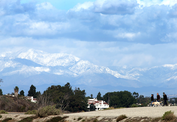
While Northern California faced the brunt of the storms, a less powerful system moved into Southern California overnight, bringing scattered showers Saturday morning. The rain was harder to the north along the Central Coast. The wet conditions should continue on and off through the weekend.
But the much of the concern is focused in the Bay Area and Sierra.
"It's a once-in-10-year event," said Zach Tolby, a meteorologist with the National Weather Service in Reno, Nev. "It's the strongest storm we've seen in a long time, the kind of setup we look for to get significant flooding."
Indeed, large swaths of the Bay Area, Sierra foothills, Central Coast and parts of the Sacramento Valley were under flash-flood warnings. Flood concerns are heightened because officials fear that the snow may quickly melt due to heavy rain.
The so-called atmospheric river of airborne moisture known as the "Pineapple Express" will be felt across much of the state this weekend, though rain will be much heavier in the north than in the south.
"It's going to be like buckets of water for a fairly sustained period of time," Tolby said.
Wind gusts on mountaintops could top 130 mph in the northern Sierra, which is typical, Tolby said. At lower elevations gusts could reach 30 or 40 mph, he said, "but that's an average windy day for us."
Tolby said the storm is packing the same wallop as an atmospheric river that hit Northern California a decade ago that caused $300 million in damage, according to the U.S. Geological Survey.
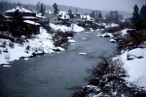
The Carson, Truckee and Susan rivers are all expected to become overwhelmed, and nearby communities may become increasingly isolated if the deluge triggers mud and rock slides.
Weather officials issued a flood watch from Saturday to Wednesday that covers much of Northern California and extends down through the Sierra to Tehachapi.
In Mono County, authorities offered sandbags to residents in preparation for the rain. In Yosemite National Park, officials announced Friday that the park would remain open through the wet weekend, but access to popular Yosemite Valley would be closed.
Earlier in the week, up to 2 feet of snow fell in less than 24 hours in the Tahoe basin on Wednesday, at times coming down at more than 2 inches an hour.
The Sierra Avalanche Center reported a slight improvement in backcountry conditions. The risk of avalanche was lowered to "considerable" even as the threat increased of historically large avalanches caused by slabs of snowpack as thick as 8 feet above a weak layer of ice laid down by a mid-December rain.
Near Lake Tahoe on Thursday, two skiers were caught in an avalanche that closed a local highway. But they were not injured, officials said.