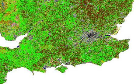
Maps are works of art, mesmerising the eye while expanding the world. And this new map is engrossing. Click on the image above to see a large version (and you may need to click again, depending on your browser.)
It takes every scrap of land in the UK, down to a resolution of 25m, and identifies the habitat there. From mountains, heathers and bogs of Scotland to the broad fields of the barley barons of East Anglia, the environmental "DNA" of the nation is revealed.
The biggest habitats, with 25% of the area of the UK each, are "improved grassland' and "arable and horticulture", showing the dedication of our ancestors in raising cattle and crops. It continues today of course, and I was struck by how much of the arable land is in the east of England, presumably because it is underlain by softer, sedimentary rocks that give more fertility to the soil.
The other big habitats are "semi-natural grassland' at 13% - sheep, I guess - and "mountain, heath and bog' (16%).
It's also striking, given the forestry fuss in the UK earlier this year that "broadleaved woodland" occupies the same space as "urban areas": 6%. And of course, those woods are mere fragments of what once covered the land.
The map was created by the Centre for Ecology and Hydrology and I'll post some brief details on how they did it below. I hope you enjoy exploring the map. Let me know what you find.
• How the map was created: Land cover was derived from over 70 satellite images collected between 2005 and 2008. The satellite images contain spectral information which corresponds to different ground surfaces and vegetation types in both summer and winter. An automated classification process was used to assign a land cover type based on existing Biodiversity Action Plan (BAP) Broad Habitats to approximately 10 million land parcels. More.