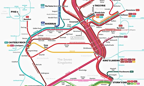
We've seen the Game of Thrones paper atlas, as well as a number of interactive versions that allow you to plot the routes of the characters through George RR Martin's hugely popular fantasy saga. Now there's some fresh Thrones cartography: a map of its hitherto unmentioned rail system.
The map, by graphic designer Michael Tyznik, suggests that dragons are not the only rapid transportation option in Westeros. It wittily reimagines the chaotic political upheaval of the kingdom as having settled down to the point where a transit system, complete with complex interchanges, has been hashed out – the river of red running down its spine is the only hint at the rampant violence. There are little in-jokes like the boxed-out apology by Harrentown station: "Please pardon our dust as Harrenhal is restored". But you can forget about ever getting even a bus past the Wall, where the services definitely terminate.
Tyznik is selling giclée prints of the map online, and there's also an even larger version taking in Essos available on his Flickr.