Several communities have been told to remain indoors as Tropical Cyclone Ilsa continued to move inland.
Look back on our live blog for updates as they happened.
Key events
Live updates
We'll leave the blog here
By Shiloh Payne
That's all for our live blog today.
To stay up to date on the latest weather warnings, you can go to:
If you're looking for more coverage on Tropical Cyclone Ilsa, you can read:
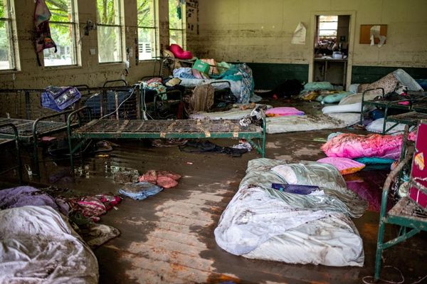
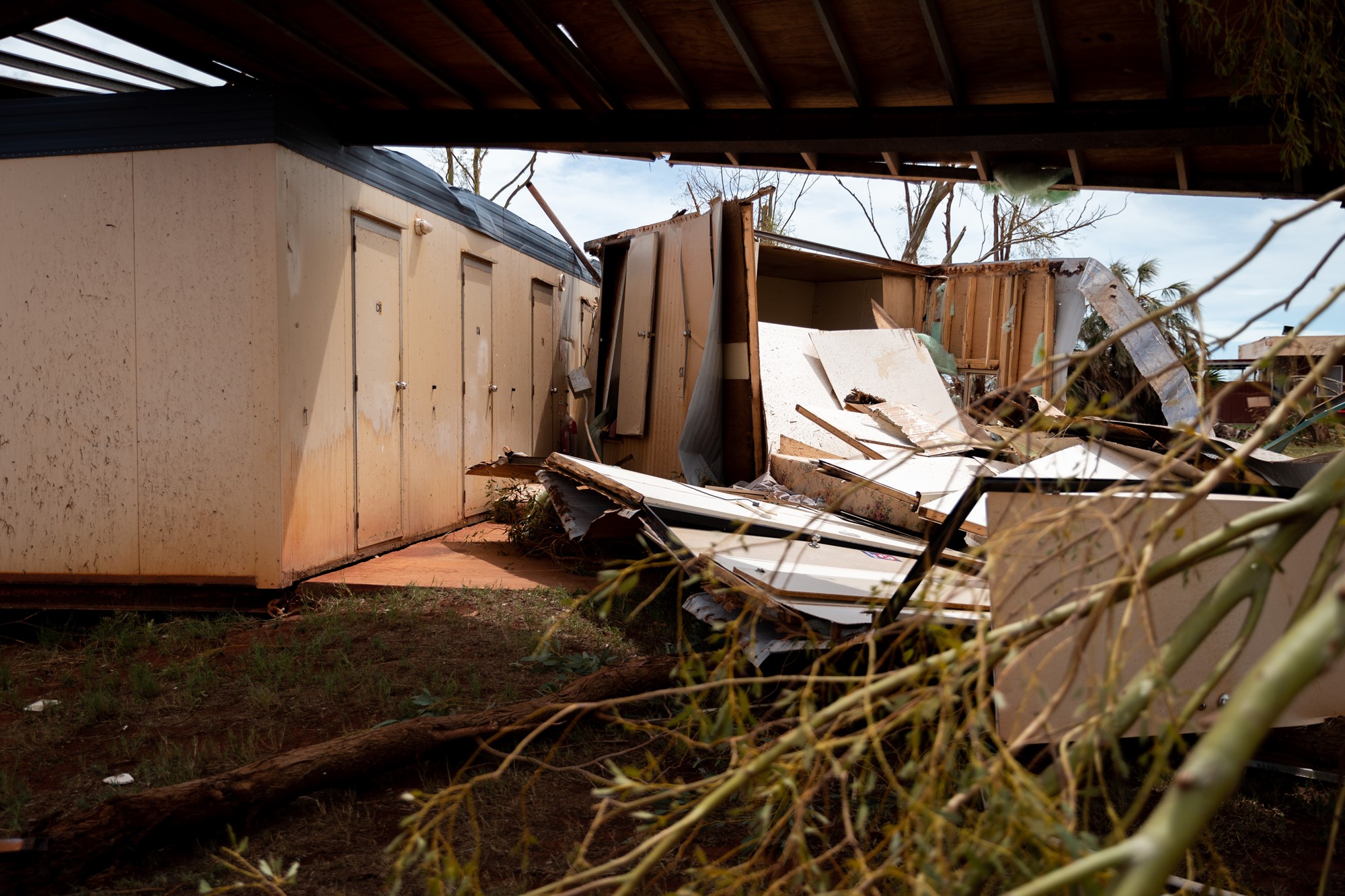
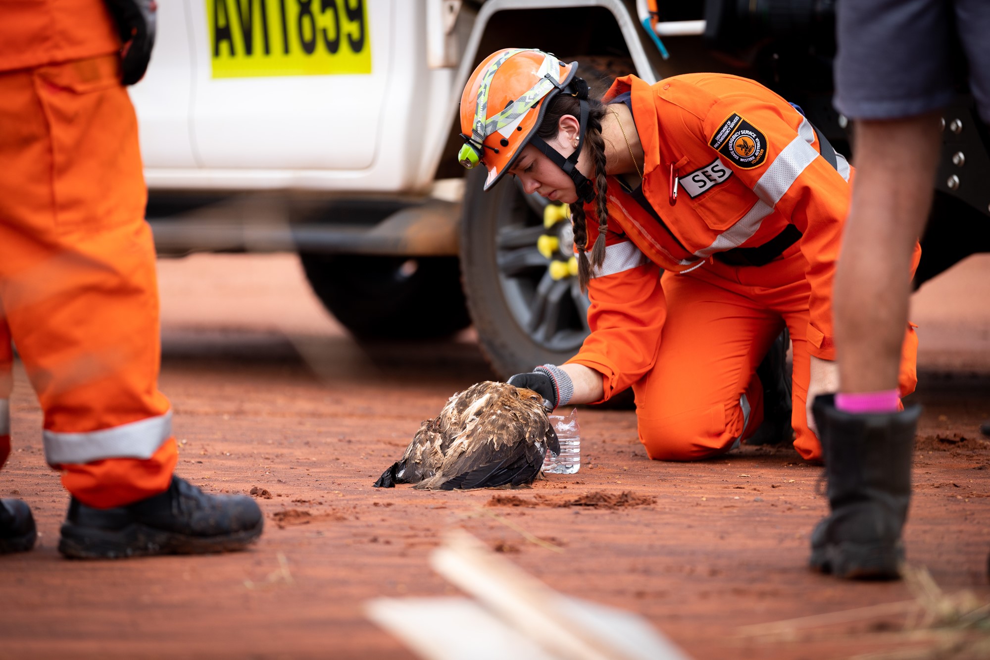
Cyclone Ilsa's destruction in photos
By Shiloh Payne
My colleagues have been out in the worst-affected regions across Western Australia today.
Here are some photos by Cason Ho:

It could be days before true extent of damage is known
By Shiloh Payne
The WA Department of Fire and Emergency Services says it will be days before the true extent of damage from Tropical Cyclone Ilsa can be assessed.
Emergency Services Commissioner Darren Klemm says localised flooding is likely, but it could be more than a day before the full extent is known.
"We might see a situation where the waters that are up over the roads now will reduce and then in 24 to 36 hours it might come up again as the water flushes its way down the river system," Commissioner Klemm says.
Here's the BOM's latest forecast looking towards tomorrow
By Shiloh Payne
Current flood warnings
By Shiloh Payne
Flooding is occurring across a number of river catchments in the Pilbara, Kimberley, Midwest Gascoyne and Goldfields Midlands regions as a result of the cyclone.
WA's Department of Fire and Emergency Services is warning residents to:
- Prepare for flooding – Western Desert, Warburton and Salt Lakes Districts.
- Take Action for minor flooding – De Grey River catchment including Marble Bar and Pardoo Roadhouse.
- Take action for isolated flooding – Sandy Desert catchment including Punmu, Parnngurr, Kunawarritji and Kiwirrkurra.
Situation still developing, premier says
By Shiloh Payne
Western Australia's Premier Mark McGowan says major towns and communities like Port Hedland and Bidyadanga were spared the worst of the cyclone.
"Early assessments show damage to those areas is fairly minimal, and no one was injured – a huge relief for those living in the area," Mr McGowan says.
"Our thoughts go out to the owners and staff at Pardoo Roadhouse who weathered the full impact of the cyclone, and have no doubt endured an intense and frightening evening."
But he says the situation is continuing to develop.
"I will continue to receive updates from the Department of Fire and Emergency Services WA on the extent of the damage, and any ongoing threat to communities."
"To all those in the Pilbara and Kimberley, take care of yourselves and your family members, and stay safe."
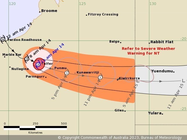
This is where Cyclone Ilsa is tracking
By Shiloh Payne
Here are the latest details on flooding
By Shiloh Payne
Flood warnings are current for the De Grey River and Sandy Desert catchments for possible minor flooding.
WA's Department of Fire and Emergency Services is warning areas of very heavy rainfall are expected to be occurring with intense rainfall totals of 150 to 300mm with higher localised falls possible from Friday into Saturday along the path of the cyclone.
Forecast rainfall in the flood watch area is expected to result in river rises, areas of flooding and may adversely affect road conditions. Roads may become impassable and some communities may become isolated.
Here are the latest warnings:
- Prepare for flooding – Western Desert, Warburton and Salt Lakes Districts.
- Take Action for minor flooding – De Grey River catchment including Marble Bar and Pardoo Roadhouse.
- Take action for isolated flooding – Sandy Desert catchment including Punmu, Parnngurr, Kunawarritji and Kiwirrkurra.
Pardoo Roadhouse bears brunt of Severe Tropical Cyclone Ilsa
By Shiloh Payne
Pardoo Roadhouse in Western Australia's Pilbara has been "wiped out" by Tropical Cyclone Ilsa, with one of the owners saying he feels "lucky to be alive" after the category five system barrelled over the region in the early hours of Friday morning.
Will Batth recounted his night spent sheltering in a shipping container after the cyclone made landfall just after 12.00 am WST, with the roadhouse bearing the brunt of the ferocious storm.
Mr Batth said he and his business partner had sent staff to Port Hedland ahead of the cyclone to safeguard them, but they stayed through the night.
"It was like four hours of hell," he said. "I am just lucky to be alive at the moment."
"We took a chance and made the dash and I don't know how, with the adrenaline, we managed to open the sea container door and managed to hide in there."
- You can continue reading this story from Pamela Medlen here.
Where is Cyclone Ilsa tracking?
By Shiloh Payne
According to the BOM, the system is forecast to continue to track in a south-east direction and move further inland across the northern parts of the interior as it slowly decays later today and into Saturday.
It is expected to move into southern parts of the Northern Territory overnight.
Senior meteorologist Sally Cutter says Cyclone Ilsa is expected to move quickly through the NT with heavy rainfall and potentially damaging winds near and to the south of the low.
"With the heavy falls associated with this low as it moves, we could see falls up to 100mm or even a little bit higher," Ms Cutter says.
"Most of them will be a little bit lower, maybe in that 50 to 80mm mark.
"But those really intense rainfalls are going to fall over a space of a few hours, so there could be some flash flooding."
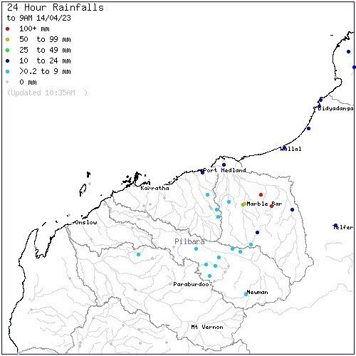
Here are the overnight rainfall totals
By Shiloh Payne
The heaviest of the rain in the 24 hours to 9 am was around Marble Bar.
Here's a breakdown of the heaviest falls in that time according to The BOM:
- Tumbinna Pool - 132mm
- Bamboo Creek - 195mm
- Marble Bar - 63mm
- Marble Bar TM - 48mm
- Tefler Airport - 23mm
- De Grey - 18mm
That's all from the press conference
By Shiloh Payne
To recap:
- Tropical Cyclone Ilsa is now a category two and continues to track east.
- Authorities are working to assess damage to roads and infrastructure.
- Warnings remain for areas east of Telfer.
Will highways be reopened in the next couple of days?
By Shiloh Payne
Commissioner Klemm is now taking questions.
He says assessments have to be done on the Great Northern Highway and other roads before they are reopened.
"Obviously, there's a number of bridges through that area and floodways and the like which will have to be assessed," Commissioner Klemm says.
"But you know, the early indications are that, and it certainly has been a pretty static message from Main Roads, has been that they have anticipated somewhere in the vicinity of 48 hours of closure post the passage of the cyclone."
Authorities are making contact with remote communities, commissioner says
By Shiloh Payne
"Today, we're making contact with remote communes, mine sites and pastoral stations to check on their welfare and I can advise you, as I've already said, Bidyadanga has escaped any structural damage, as has Jimparinya, an Aboriginal community," Commissioner Klemm says.
"Sand Fire Roadhouse, Yaree Station and De Grey Station are also reporting no major damage.
"Crews have completed the assessment of Port Hedland and South Hedland this morning and there's no visible damage to roads or infrastructure in those areas."
DFES commissioner highlights preparation works leading up to Cyclone Ilsa
By Shiloh Payne
Fire and Emergency Services Commissioner Darren Klemm says good preparation was done in the lead-up to Cyclone Ilsa.
"I want to thank the communities across that quite extensive area for the actions that they've taken over the course of the week to make sure that they were prepared in and around their communities for the passage of the cyclone," Commissioner Klemm says.
"Overnight, the 13 DFES centre and the SES call centre were stood up as well and we only received a small number of calls overnight for assistance."
Air and land assessments underway
By Shiloh Payne
Fire and Emergency Services Commissioner Darren Klemm says crews have been out since 4 am when the danger passed Port Hedland.
"The red alert currently still stretches between Wallal Downs and De Grey and out to the east, and as you heard already, the danger is certainly not over yet for those communities that are east of Telfer," Commissioner Klemm says.
He says the department is conducting assessments for the air and by land.
"We're also having crews come down from the north from Broome and they've been to Bidyadanga this morning and we're happy to report that there has been no structural damage of significance at Bidyadanga."
Flood warnings remain
By Shiloh Payne
Todd Smith says more than 150mm of rain has been recorded in the De Grey river catchment which could lead to minor flooding at the Great Northern Highway.
Communities urged to remain vigilant
By Shiloh Payne
Todd Smith says the category two system is tracking east and passed directly over Telfer in the last couple of hours.
"There's still a cyclone warning out for Telfer and also for communities well inland through the great sandy desert," Mr Smith says.
"We have communities, Kirrakurra and others which are still in that warning zone.
"I wanted to just really emphasise for those communities, even though the system has crossed the coast, please remain vigilant.
"We are expecting damaging to destructive winds today and into this evening as the system continues to track towards the east."
Port Hedland 'dodged a bullet', meteorologist says
By Shiloh Payne
BOM meteorologist Todd Smith says it's likely the weather station's recording of a wind gust at 289kph will go down as the strongest wind gusts ever recorded by the Bureau's equipment in Australia.
"It just shows how strong this system was when it was approaching the coast," Mr Smith says.
"The fact that the cyclone took a south-eastward shift in the track late yesterday afternoon really means that Port Hedland dodged a bullet last night.
"Most of the impacts as we've seen are further to the east, and the impacts in Port Hedland were really light with the system tracking about 150 km further along the track."
Tropical Cyclone Ilsa is now a category two system
By Shiloh Payne
Sue Ellery says Cyclone Ilsa is continuing to move eastward as a category two cyclone.
"There are several remote communities and mining operations which are yet to be impacted," Ms Ellery says.
"To all of the communities in the Pilbara and the Kimberley, please take care of yourselves, your family members and stay safe.
The impact of severe Tropical Cyclone Ilsa is not over yet.