YAMAGUCHI -- This special edition is a journey through time and space traversed by reading text and looking at photos.
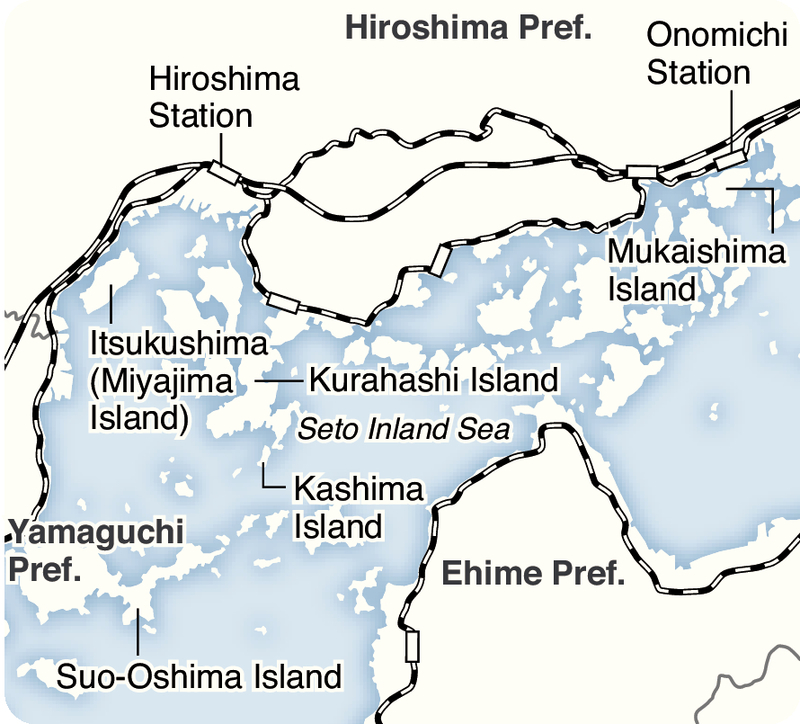
Four volumes of folklore scholar Tsuneichi Miyamoto's 15-volume "Watashi no Nihon Chizu" (My maps of Japan), published by Miraisha, guide readers through the seascapes and islands of the Seto Inland Sea during the Showa era (1926-1989).
Miyamoto, who during his life walked 160,000 kilometers, which is equivalent to circumnavigating the globe four times, was born and raised in Suo-Oshima, Yamaguchi Prefecture.
The cover of "Watashi no Nihon Chizu -- Setonaikai 3 Suo-Oshima" volume nine features a sepia photograph of a fishing boat loaded with a portable children's shrine. This "kodomo mikoshi" was used in festivals at the Shitata Hachimangu Shrine close to where Miyamoto was born.
Miyamoto looked kindly on the white-garbed children, writing, "Sometimes [the shrine] was put on a fishing boat. This was considered good luck." This brought back childhood memories of walking in the daimyo's procession during the Ujigami festival in my hometown.
At the beginning of volume four "Setonaikai 1 Hiroshima-wan Fukin," Miyamoto wrote, "Just south of where I was born is Mt. Shiraki, which is not even 400 meters high ... The wonderful view from the top looks out over the western Seto Inland Sea."
Hiroshima Bay is on the northern side of Suo-Oshima, from which Itsukushima (Miyajima island) can be seen. "When a steam locomotive passed by, you could see the white smoke from the top of the mountain," he wrote.
This volume is filled with Showa-era nostalgia from the coastlines and islands of Yamaguchi and Hiroshima prefectures, which surround Hiroshima Bay.
In the chapter on Kurahashi Island, which is now part of Kure, Hiroshima Prefecture, he wrote, "Honura in Kurahashi is an old shipyard ... that made vessels including those that carried Japanese missions to Tang Dynasty China."
A photograph of the island's Honura district from the late 1950s shows a lonely shipyard.
In a phone call, Tsuneharu Kano, 89, a Honura resident who researches local history, said, "Levees were built after Miyamoto visited. There's no shipyard anymore."
Miyamoto marveled at the nearly 200 terraced fields on Kashima Island to the south of Kurahashi. These terraced fields were intensively cultivated at that time, but according to Kano, the number of farmers working them has declined significantly.
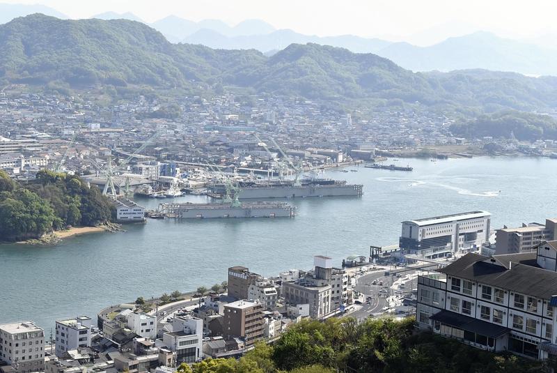
Volume six "Setonaikai 2 Geiyo no Umi" introduces the coastline of Hiroshima Prefecture and its offshore islands. One of the sites is Onomichi, which Miyamoto described as "a town that was developed on a slope."
"People going up and down the stone steps ... are cheerful and don't mind walking along this path. They're very approachable," he wrote. Reading this made me feel like I too was climbing the stone steps.
Volume 12 "Setonaikai 4 Bisan no Seto Fukin" takes you to the eastern part of the Seto Inland Sea.
In 1966, Miyamoto visited the hamlet of Tsubone in Aioi, Hyogo Prefecture, where residents made a living fishing despite the remote location. He wrote, "I told an old man on the beach, 'This is a nice place,' to which he replied, 'It is a nice place.'"
I felt like I was walking along side Miyamoto, who wrote, "I stood for a while on the beach gazing at the cove, pondering this kind of life."
Fifteen volumes of 'Watashi no Nihon Chizu' were published by Doyukan from 1967 to 1976. The initial plan was for 30 volumes.
From 2008 to 2016, Miraisha reissued "Watashi no Nihon Chizu" as part of a collection of the works of Tsuneichi Miyamoto.
A 1961 photograph of the Atomic Bomb Dome was used for the cover of volume four "Setonaikai 1 Hiroshima-wan Fukin."
The cover photo on volume six "Setonaikai 2 Geiyo no Umi" is from 1957 and shows the Tsushima pier in the Sannose district of Shimokamagaricho, which in 2003 became part of Kure, Hiroshima Prefecture. The pier's stone steps were used for loading and unloading passengers and cargo.
Four of the 15 volumes cover the Seto Inland Sea. Other volumes cover areas such as the Shimokita Peninsula in Aomori Prefecture, Sado Island in Niigata Prefecture, the Goto Islands and travels on Iki and Tsushima islands in Nagasaki Prefecture, Kyoto and Okinawa.
Miyamoto lived in Fuchu in western Tokyo from 1961 until he died. His findings after returning to his home base from his walks are collected in a volume called "Musashino-Ome."
Read more from The Japan News at https://japannews.yomiuri.co.jp/