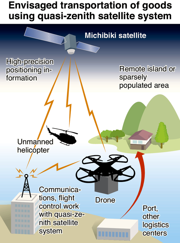
The government plans to begin full-fledged experiments this autumn on the transport of goods via drones using information from the Michibiki quasi-zenith satellite system (see below).
By improving the flight precision of drones using positioning information from Michibiki, the government aims to achieve commercialization of such transport methods as early as fiscal 2020.
It hopes to use the system as an effective means of transporting goods to remote islands and sparsely populated areas amid a serious labor shortage in the logistics industry.
The Michibiki satellite system is scheduled to begin transmitting information in November. The government therefore plans to increase from this autumn the number of feasibility tests on drones capable of receiving signals from Michibiki.
The government has high hopes for drones, unmanned helicopters and other modes of transportation as alternative means for transporting goods to remote islands and underpopulated areas with dwindling numbers of inhabitants. Shipment to such locations can be costly due to the small number of deliveries and long driving distances for trucks.
Feasibility testing began about two years ago on Yushima island in Kamiamakusa, Kumamoto Prefecture, in which a drone successfully flew 6.5 kilometers en route to a delivery. Flights can handle loads of up to 150 kilograms, including the drone's weight, according to sources.
Drones fly along a programmed route, but can be thrown off course by strong sea winds while heading to remote islands. A system must also be devised to prevent collisions when multiple drones are airborne. With this in mind, the government aims to improve flight accuracy by using positioning information from Michibiki.
Experimental drone flights were conducted in Fukushima Prefecture from November to December last year utilizing Michibiki, which is in the testing stage. The global positioning system, which is used for navigating vehicles and other purposes, was also used to adjust the drone's position.
The experiments yielded positioning errors of about 60 centimeters horizontally and about 30 centimeters vertically -- roughly three to six times more accurate than GPS when used alone -- while also showing how Michibiki can help avert drone collisions.
The government intends to push private companies to commercialize drone-based and other delivery methods as early as fiscal 2020.
--Quasi-zenith satellite system
A Japanese positioning satellite system that orbits in a figure-eight pattern over the Asia-Oceania region. Four satellites were launched from 2010 to 2017. The government aims to operate the system through a seven-satellite constellation from around fiscal 2023. As the satellite travels along a quasi-zenith orbit over Japan, positioning signals are not blocked by mountains or high-rise buildings, which enhances accuracy.
Read more from The Japan News at https://japannews.yomiuri.co.jp/