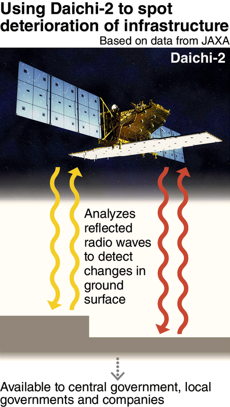
The Japan Aerospace Exploration Agency (JAXA) has developed a system to efficiently monitor the deterioration of infrastructure -- such as river embankments, airports and harbors -- using the Advanced Land Observing Satellite Daichi-2.
According to JAXA, it can monitor a wide area at once, which is expected to significantly reduce the amount of labor needed for inspections. The system will be available for a fee to the central government, local governments and private companies, to improve their disaster prevention measures.
The Daichi-2 sends radio waves to the ground and measures reflected waves. The features of the reflected waves change according to the shape of the land, allowing the detection of shifts in the ground.
JAXA applied this function to develop a system that can detect the sinking and collapse of embankments, airports and harbors. It began an experiment to verify the technology in cooperation with companies in fiscal 2014.
The system precisely detected a sinking of more than 30 centimeters in embankment of the Yuragawa river, which flows through Kyoto and Hyogo prefectures, and a seven-centimeter drop in land at Kobe Airport over a year.
This led JAXA to conclude that the technology had reached the level of practical use.
The central government manages a total of about 9,000 kilometers in river embankments across the nation. Its guidelines stipulate that it should check them visually twice a year and measure them once every five years.
However, the requirements have become a heavy burden due to labor shortages and fiscal difficulties. The situation is the same for airports, harbors and other embankments that are managed by local governments or companies.
According to Naoya Tomii, JAXA's manager for satellite applications: "Observation and surveys conducted by people can be replaced by monitoring satellites. If the system is introduced in the government's guidelines, it will reduce the labor expended and the cost of inspections."
Read more from The Japan News at https://japannews.yomiuri.co.jp/