KYOTO -- The term Rakuchu has long been used to refer to inner Kyoto, and the area outside Rakuchu is called Rakugai. But when asked where the boundary lies between Rakuchu and Rakugai, it is harder to answer than expected. Few people, including those in Kyoto, can correctly answer the question.
Raku comes from Rakuyo, which means Loyang in Chinese, the ancient Chinese capital.
Emperor Kanmu (737-806) relocated the capital to Heiankyo, now Kyoto. His second son, Emperor Saga, who reigned from 809 to 823, favored Chinese-style culture. For that reason, it became popular to refer to the eastern half of Heiankyo -- known as Sakyo -- as Rakuyo in prose and poetry.
The western half, or Ukyo, was referred to as Choan, which is the Japanese pronunciation for Changan. Located about 370 kilometers west of Loyang, Changan also is known as the capital of several ancient Chinese dynasties.
The western part of Heiankyo gradually waned in prosperity, and subsequently returned to paddies and fields. Therefore, Rakuyo -- which indicates Sakyo -- became a byword for Kyoto.
But Sakyo also went into decline rapidly toward the medieval period due to warfare, massive fires, major earthquakes and epidemics. The total population of Kyoto in the 16th century is estimated at about 30,000.
The dwindled Kyoto was divided into two cities -- Kamigyo on the northern side and Shimogyo on the southern side -- and the area between the two cities became paddies and fields.
Yet people in Kyoto at that time, especially court nobles, still recognized Sakyo in Heiankyo as Rakuchu, according to Masayoshi Kawauchi, a professor of Japanese medieval history at Nara University.
"They felt strongly that Rakuchu covers the areas that extend from Ichijo-oji street in the north to Kujo-oji street in the south. By calling the outside area Hendo [remote region] or Rakugai, they strictly distinguished Rakuchu from other areas," he said.
From this point, the Rakuchu and Rakugai issue becomes more complicated.
As many houses were built north of Ichijo-oji, a situation developed in which more than half the areas in Kamigyo were actually located in Rakugai.
The gap emerged from the perception of Kyoto held by the nobility, and the actual situation of the city. As a reference, the Hana no Gosho palace -- the residence of Ashikaga Yoshimitsu (1358-1408), the third shogun of the Muromachi shogunate, and the base of the shogunate -- also was located north of Ichijo-oji street. If the definition of Rakugai is based on the nobility's traditional feelings, the palace was located in the Rakugai area.
Toyotomi Hideyoshi (1537-1598), who unified the country, expanded and integrated the divided city of Kyoto. The first thing he did was ask about the areas formerly known as Rakuchu, as the boundaries had become indistinct following a long period of warfare.
Hosokawa Yusai, known as a military commander and waka poet, could answer Hideyoshi's question. According to Hosokawa, Rakuchu was the area that extended to Kyogoku in the east, Kamoguchi in the north and Kujo in the south. The areas east from Aburanokoji were part of Rakuyo.
An unfamiliar name these days, Kamoguchi was located a good ways north of Ichijo.
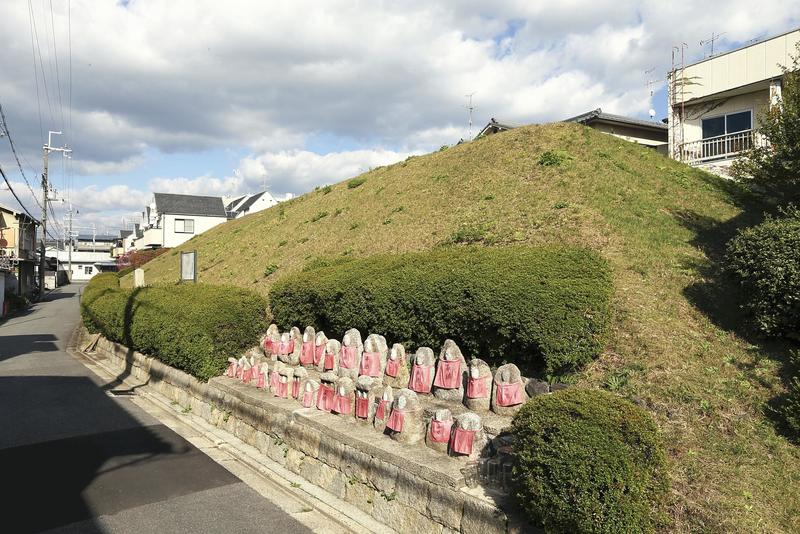
Hideyoshi constructed 22.5-kilometer-long earthworks called odoi to delineate the border between Rakuchu and Rakugai. They were earth mounds about five meters high and 20 meters wide, and moats were also built outside them. Unlike the quadrangular shape of Heiankyo, which was a preplanned city, Kyoto had irregular boundaries, because Hideyoshi defined the border based on the actual situation of the city to a certain extent.
Japanese cities are typically not surrounded by walls, but Kyoto at that time was an exception.
Thereafter, the areas both inside and outside the odoi earthworks became urbanized following periods of peace. In the Meiji era (1868-1912) and the Taisho era (1912-1926), most of the odoi were destroyed, as they no longer served any purpose.
As a result, the words Rakuchu and Rakugai are often used today, but only those with a good knowledge of historical events can point out the boundary.
***
This column, which appears once a month, is about various aspects of the culture of Kyoto.
Mori was born and raised in Kyoto. He has 30 years of experience in reporting about Kyoto culture. He has extensively covered scholars of the New Kyoto school, the heads oftea ceremony and flower arrangement schools, as well as maiko in the Gion area of the city.
Read more from The Japan News at https://japannews.yomiuri.co.jp/