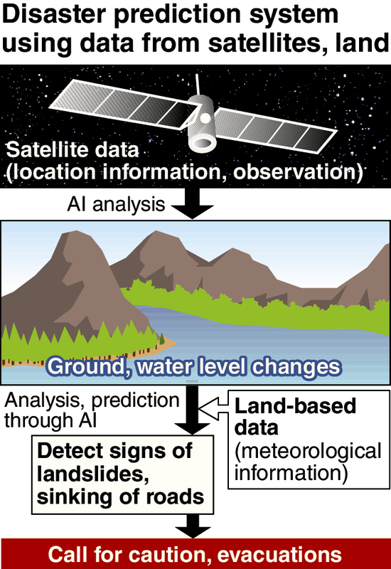
The government plans to launch a new disaster prediction system in fiscal 2020, using data from both satellites and the ground, in an effort to enable local governments to efficiently call for quick evacuations in the event of signs of a natural disaster.
Using artificial intelligence, the system will analyze data round the clock -- checking changes in terrain, rainfall and other factors -- from monitoring spots where such disasters as landslides and floods are likely to occur.
The system was proposed at a July 4 meeting of the Internal Affairs and Communications Ministry's panel of experts, which is tasked with discussing how to further harness satellite data, and led by Prof. Shinichi Nakasuka of the University of Tokyo.
Following the proposal, the ministry has appropriated necessary funds through its budgetary request for fiscal 2019 to realize the system in cooperation with such authorities as the Land, Infrastructure, Transport and Tourism Ministry and the Japan Meteorological Agency.
Under the new system, disaster-prone locations will be designated in advance as monitoring spots, based on relevant information including hazard maps developed by local governments. Censors will be placed at these locations to observe the amount of rainfall and the condition of the terrain. Also, the Michibiki quasi-zenith satellite system (see below) will be used to get relevant data -- on about an hourly basis -- such as changes in terrain, rainfall and soil saturation.
The data and other meteorological information will be examined using artificial intelligence software to gauge the disaster risk.
The new system is expected to accurately forecast the locations of disasters, thereby enabling local governments to effectively issue warnings and evacuation orders to residents.
"We want to protect people's lives from disasters via insights from space and realize a disaster-resilient society by conducting evacuations as early as possible," a senior ministry official said.
The recent record rainfall that hit mainly western Japan caused landslides and river floods, leaving over 200 dead or missing. The disaster has highlighted the importance for both the central and local governments of considering how to improve the accuracy of predictions.
--Quasi-zenith satellite system
A Japanese positioning satellite system that transmits radio waves from space and provides location information on objects on the ground. The satellites travel over Japan in a quasi-zenith orbit, thereby preventing signal blockage by mountains or high-rise structures. The satellites are expected to provide highly accurate measurements with a margin of error of about several centimeters. A total of four satellites have been launched to provide positioning information from November of this year.
Read more from The Japan News at https://japannews.yomiuri.co.jp/