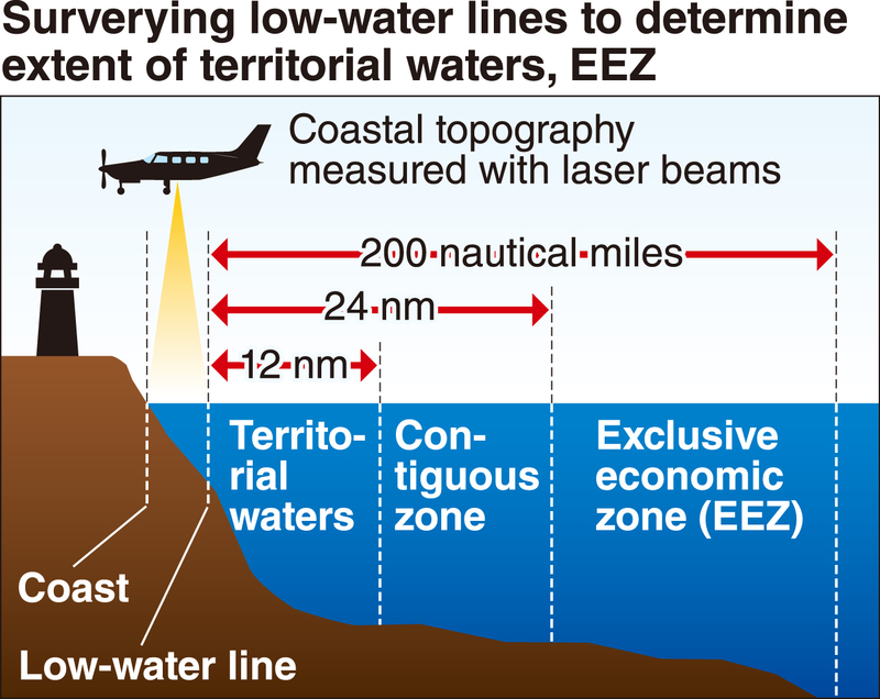
The Japan Coast Guard is planning to introduce for the first time an airplane specifically for surveying to enhance its ability to determine the low-water line, which is used as the baseline to calculate the extent of Japan's territorial waters and exclusive economic zone.
The agency is believed to desire more precise data as a basis for Japan's territorial waters and EEZ, as China and other surrounding countries pursue their own maritime interests.
It plans to introduce the airplane in fiscal 2021 and is requesting related expenditures in its initial budgetary request for fiscal 2019.
The low-water line occurs at the intersection of land and sea at low tide.
The United Nations Convention on the Law of the Sea stipulates that a country's territorial sea extends 12 nautical miles from the low-water line, while its EEZ extends 200 nautical miles from the baseline.
Since 2014, the JCG has confirmed 84 cases of unauthorized martime activity by vessels from China, South Korea and other countries in Japan's EEZ and other maritime zones.
In light of such moves, the JCG has undertaken more accurate surveying since fiscal 2017 to better measure the low-water line.
The agency has deployed 16 autonomous ocean vehicles (AOVs) -- unmanned devices that measure wave height and tide levels -- several kilometers off the Sea of Japan and East China Sea, using the devices to measure tidal ebbs and flows in various areas over the course of a year.
The JCG has also measured the topography and depth of the seabed using laser beams from airplanes flying over coastal areas.
By combining these measurements, it is said that the low-water line can be determined more accurately compared to only using monthlong measurements of ebbs and flows taken by undersea equipment.
The JCG is temporarily using patrol and rescue airplanes for surveying activities.
However, it will take at least 10 years to complete precise surveying as Japan's shoreline is about 35,000 kilometers long.
Surveying activities using such airplanes are likely to be suspended should an accident at sea occur, so the JCG decided to introduce an airplane specially designated for maritime surveying to accelerate progress.
The JCG is also considering the deployment of four additional AOVs in fiscal 2019.
Read more from The Japan News at https://japannews.yomiuri.co.jp/