ISRO’s high-resolution imaging satellite Cartosat-2 has descended into Earth’s atmosphere on February 14, 2024.
“Cartosat-2, ISRO’s high-resolution imaging satellite, bid adieu with a descent into Earth’s atmosphere on February 14, 2024, as predicted. ISRO had lowered its orbit from 635 km to 380 km by early 2020. This strategic move minimized space debris and underscores ISRO’s commitment to sustainable space exploration,” space agency posted on its official X (formerly Twitter) account on Friday.
Cartosat-2, ISRO’s first satellite in the second generation of high-resolution imaging satellites was launched on January 10, 2007. It weighed 680 kg at launch and operated in a sun-synchronous polar orbit at an altitude of 635 km. Until 2019, it provided high-resolution imagery for urban planning.
“Initially, Cartosat-2 was expected to take about 30 years to naturally de-orbit. However, ISRO opted to lower its perigee using leftover fuel to comply with international guidelines on space debris mitigation. This involved reducing collision risks and ensuring safe end-of-life disposal, following recommendations from organizations like the United Nations Committee on the Peaceful Uses of Outer Space (UN-COPOUS) and the Inter-Agency Space Debris Coordination Committee (IADC),” the space agency said.
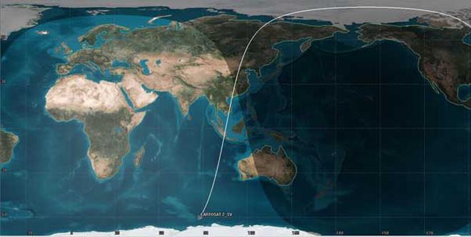
ISRO’s System for Safe and Sustainable Space Operations (IS4OM) team at ISRO Telemetry Tracking and Command Network (ISTRAC) predicted Cartosat-2’s atmospheric re-entry for February 14.“Electrical passivation was completed on February 14 and tracking continued until re-entry. The final telemetry frames confirmed successful passivation, with the satellite reaching about 130 km altitude,” ISRO said.
It further said that this provided an opportunity to assess indigenous tracking capabilities, with the Multi-object tracking radar at Shriharikota utilised for tracking.
“The final prediction placed Cartosat-2’s re-entry over the Indian Ocean at 10:18 UTC / 3:48 pm IST on February 14. Analysis indicated that all major spacecraft components would demise during atmospheric re-entry,” ISRO added.
It further said that the Cartosat-2’s successful de-orbiting at its end-of-life represents a significant step for ISRO in ensuring the long-term sustainability of outer space activities.