After a season of intense heatwaves, India will not have a lot of respite this monsoon, with the India Meteorological Department (IMD) forecasting a ‘below normal’ monsoon season. On Friday, IMD further downgraded its monsoon forecast to 90 percent of the long-period average as against the earlier 92 percent, and forecast a warmer June.
One reason will be an ‘El Niño’ brewing in the Pacific Ocean that can lead to a weak monsoon. There are concerns about this year experiencing a ‘super El Niño’ event beginning in the second half and stretching on to early next year.
El Niño and La Niña are opposite phases of the global ocean atmospheric phenomenon El Niño–Southern Oscillation (ENSO), a powerful atmospheric-ocean phenomenon.
The National Oceanic and Atmospheric Administration describes the phenomenon as follows: “During normal conditions in the Pacific ocean, trade winds blow west along the equator, taking warm water from South America towards Asia. To replace that warm water, cold water rises from the depths…. During El Niño, trade winds weaken. Warm water is pushed back east, toward the west coast of the Americas.”
El Niño is associated with increased rainfall and flooding in parts of South America, East Africa, and the southern United States; drought conditions in eastern and northern Australia, Indonesia, southern Africa, and parts of South Asia due to suppressed monsoon activity; and reduced Atlantic hurricane activity, according to the World Meteorological Organization (WMO).
But, each El Niño event is unique in terms of its evolution, spatial pattern and impacts. It typically occurs every two to seven years and lasts around nine to twelve months.
“After a period of neutral conditions at the start of the year, climate models are now strongly aligned, and there is high confidence in the onset of El Niño, followed by further intensification in the months that follow,” said Wilfran Moufouma Okia, Chief of Climate Prediction at WMO. The organisation does not use the term ‘super El Niño’ because it is not part of its classifications.
With the war in West Asia still impacting global energy supplies, the El Niño (super or not) will further add to woes. India’s economy has also been impacted by these global events and a weak monsoon will have a cascading impact on sowing, yields, food security, water security, energy demand, food inflation and possibly even strong heatwaves next summer.
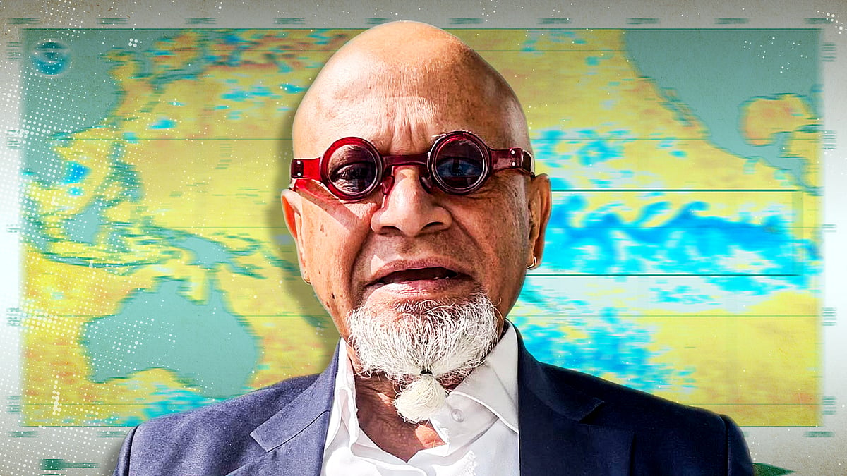
What does the science say so far about this year’s El Niño and what steps could India take to better prepare for its impacts? We spoke to Raghu Murtugudde, an earth systems scientist, Emeritus Professor at the University of Maryland, and visiting faculty at the Kotak School for Sustainability at Indian Institute of Technology (IIT), Kanpur.
Edited excerpts:
There is a lot of discussion about the El Niño developing later this year, and there is some concern about it being a ‘super’ El Niño. It is even being compared to the El Niño event of 1877 which is linked to the Great Famine that year in British-ruled India. What do we know so far and in your experience, is it going to be a super El Niño?
‘Super El Niño’ is just a made-up word, but nonetheless indicates a very strong El Niño. Will this one grow strong? Models are saying that, and there seems to be a consensus about it. But a consensus answer is not always the right answer, because all the models are kind of latching on to similar things.
There is a supply of warm water below the surface on the equator, which tends to come up in a couple of months. But how strong it will get will depend on whether that will create this kind of positive feedback or vicious cycle with sea surface temperatures, pressure gradients, winds… they all begin to talk to each other and give feedback, then you can get a strong El Niño. But models are notoriously bad at predicting the amplitudes very well.
When do you think the picture will be clear?
Right now, it's already clear that this year we'll have an El Niño, because when there is so much warm water in the tropical Pacific, we will get something like an El Niño.
But what matters is what that will do to the monsoon. It also depends on whether the models can say something about the onset, the distribution of rainfall in regions and time. These things are complicated and models are not terribly good at it. So, we have to watch.
Hopefully in the next couple of months, everything will begin to become more obvious because already, the monsoon onset (which was earlier forecast for May 26 by the IMD) is delayed. It might happen in the first week of June, which will still be normal. But if it gets delayed further by another week or two, then there might be speculation or suspicion of a super El Niño again.
A 2006 paper that analysed 132 years’ data found that not every El Niño event has led to a severe drought but severe droughts in India have always been accompanied by El Nino events. You had mentioned that there is about 60 percent incidence of an El Niño year impacting the Indian monsoon. In the other years, rainfall has been somewhat normal. Is there a possibility that some of this fear could be unfounded?
IMD has forecast a monsoon only about 6 percent to 8 percent below normal [revised to -10 percent later] but that also misses the point about the distribution, right? Some things like water resources may be affected by total rainfall. But distribution is what matters for agriculture and food production. There is a risk and it is now a question of how we prepare for it.
For example, the government has already restricted sugar exports and they ramped up the export tax on edible oil. But these are also related to the war. Pre-monsoon heat waves and rainfall has already affected mustard, wheat. El Niño is just one thing and it is an important thing to consider.
Haven’t El Niño events come in quick succession, that is, between 2024 and 2026?
It typically happens from two to seven years. In that sense, it's not really out of the ordinary. A ‘super’ El Niño last happened in 1877, so it is not like one did not happen during the non-global warming period. It's just that El Niño adds to global warming because El Niño itself is a mini version of global warming. It spews out the heat stored in the oceans.
That means the conditions now are very different than the 1877 super El Niño. Also, back then, we didn't know much about El Niño. We are retrofitting today’s knowledge to history. Yes, famines happened back then, but famines could have been influenced by human decision-making, policy making as well. What happens now will be different in that sense and we have to be prepared.
What are the chances of the Indian Ocean Dipole (IOD), which suppresses El Niño as well as the ‘spring predictability barrier’—which prevents accurate forecast in the first half of the year—working in our favour and leaving the South Asian monsoon unscathed from the effects of El Niño?
An IOD event happens in September-November. In general, it tends to mitigate El Niño. The question is, will we duck under?
The best way to think about it is that the monsoon itself is a heat source. It has its own mind. We are always obsessed about what El Niño does to the monsoon but monsoon happens six months before the El Niño peaks. What we don't know very well is what monsoon does to the El Niño. That's why we say only 60 percent incidences of weak rainfall are explained by El Niño. But what if the other 40 percent are where the monsoon is changing the El Niño itself?
Since the monsoon is running late, what advice will you give to the farmers who are waiting to sow in the Kharif cycle?
For farmers, local onset will be important. Farmers need more accurate information on those. We ourselves at IIT Bombay were doing those for irrigation etc. Farmers require hyper-local early warnings. IMD provides forecasts at the block scale or district scales but farmers need more [granular information]. IMD also has to move towards hyper-local early warnings. There are a lot of private players now who are trying to do that.
A below-normal monsoon could also mean that certain regions, say like Marathwada, Vidarbha, will get much less rain. Marathwada had a severe deficit after the 2015 El Niño.
Exactly. So, all-India ‘mean’ rainfall is kind of a meaningless thing. At some point, it used to be an indicator of total grain production when Kharif was the big producer. But now Rabi is also producing as much as Kharif.
The problem is, Rabi is also getting hit by heatwaves and pre-monsoon rains. Wheat crop, onions are concerns. With grain storage, you can manage a little bit or reduce export and so on. In 2023, they reduced rice export. This time they have banned sugar but onions are not stored that much, so it's always a gamble.
Farmers gamble all the time, but they don't get enough attention. The government gambles and claims success when they are correct. If they are not correct, they will keep quiet.
Ultimately this can impact food prices and it will have a cascading effect on inflation, right? Everything is interlinked in that sense?
Absolutely. The war is not over yet. So, what else is going to happen? Already petrol prices are up. Even if onion production is good, transportation costs go up, then prices will go up. Transportation costs are going to be hit hard as well. Oil prices don’t seem to be showing any sign of coming down.
Your 2015 paper explained how ‘westerly wind bursts’ strongly affect El Niño. Has there been any more research on this front since then?
It's just the same thing that we know, it is a part of El Niño and they are not always easy to predict. The El Niño models are climate models. Westerly wind bursts are weather events. Climate models are not good at predicting weather events. But once they start, they push the warm water eastward [from the west of the Dateline] and become what is called multiplicative noise.
As they push eastward, they grow larger in strength and area. At that time, models capture them because they are slowly becoming climate-scale. So, the question is when and how will they appear? That still remains a challenge because right now, westerly wind bursts can suddenly accelerate the growth rate of El Niño. If they don't occur, then maybe El Niño will grow slower and won't be as hysteric.
If there is a super El Niño brewing in the coming year, how well can India prepare itself in terms of energy needs, water, food security, inflation?
Some unprecedented measures will have to be taken. Early warnings are a crisis management thing. You don't want to be stuck in crisis management. You want to have room in the budget for resilience building. That should be a longer-term plan.
Coal is convenient to burn now because war affects fuel prices and heatwaves are here. If heat demand goes up, then power plants run on coal. But in the longer term, you want to have solar. Solar should have also gone up but [there are challenges with respect to] distribution network, grid and so on. There are background adaptation responses that have to be continually getting better.
The government has to track what is going to be hit worse, say, wheat, rice, beans, pulses or cotton. Sugarcane and cotton can be managed because they are cash crops and don't affect daily life… If their export is stopped, then that's okay but farmers have to be protected.
Preparing is a two-part problem. One is the early warnings and response. This is rapid response, rapid recovery. The lower part is the adaptation part, you will need risk maps for quite literally every taluka. It should have a risk map for heatwaves, damage to agriculture, infrastructure, energy supply. India needs to build those.
Our water resources are already under strain. India's groundwater levels are worrying. That's part of the resilience we have to build… how to exploit groundwater, but recharge it. One thing we forget is the amount of rain we get is still very high. Concentrated rain makes groundwater recharge difficult, but that's if we don't do something about it. Rainwater harvesting and proper planning can still give us lots of groundwater recharge.
This story is republished with permission from IndiaSpend, a data-driven, public-interest journalism non-profit. It has been lightly edited for style and clarity.
Newslaundry is a reader-supported, ad-free, independent news outlet based out of New Delhi. Support their journalism, here.