The best city stories from around the web this week explore the community-led “spaces of peace” in Venezuela, observe the regeneration of Harlem in New York, and ask whether it is possible to design a skyscraper without a shadow.
We’d love to hear your responses to these stories and any others you’ve read recently, both at Guardian Cities and elsewhere: share your thoughts in the comments below.
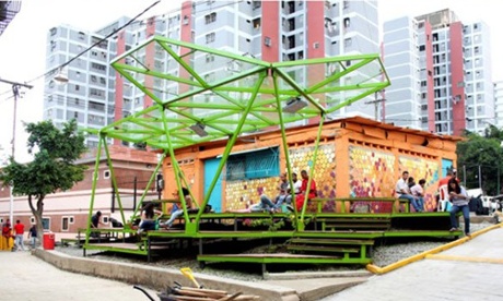
Venezuela’s ‘spaces of peace’
As Tere Garcia writes in This Big City, last year Venezuela became an “urban laboratory” for participatory city design and community development. The initiative Espacios de Paz (Spaces of Peace) brought practitioners, residents, students and public bodies together in various city neighbourhoods impacted by social division – from Caracas to Maracaibo – to create shared and creative public spaces using self-build techniques.
Garcia explores and evaluates these transformative neighbourhood projects alongside some wonderful photographs: “Projects like these are a great opportunity to work collectively, where cooperation processes are based on exchanging knowledge and experiences ... These are spaces made not only for but by the community.” The initiative has now kicked off in Mexico.
Past in present
Comparing historic city scenes to their present day versions can be fascinating – we’ve done it with old photographs in Google Street View that look back to cities in the first and second world wars.
Now, a new app promises to offer this immediate ability to compare places you are in with how they used to look in the past. Created by Asma Jaber, the app PIVOT shows users historic images of their surroundings. As Fast Co Exist explains, the idea grew out of the desire to preserve the cultural and architectural heritage of a place in danger of losing its historic fabric.
“The idea for PIVOT was born in Palestine,” explains Jaber, whose father was a Palestinian refugee from Nazareth. “There were over 400 villages destroyed in Palestine during the Nakba.” Funded by the Harvard Innovation Lab, the app’s pilot programmes are currently based in the West Bank and the Harvard campus – but the aspiration is to expand to other areas where cultures and histories are at risk of being lost, as well as areas with tourism potential or a diminished tourism sector.
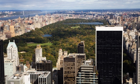
A shadowless skyscraper?
Is it possible to design a skyscraper that doesn’t have a shadow? As Wired explains, London-based architecture practice NBBJ took on that exact challenge. Computer modelling was used to design a pair of buildings, which work together to eliminate shadow. The curved glass surface of one building reflects light down into the shadow cast by the other throughout the day.
Though these buildings were designed to be located in London, the idea could be translated elsewhere. “The approach could be helpful in places like New York,” Marcus Woo writes, “where residents have resisted the construction of several new skyscrapers that they say will plunge Central Park into shadow.”
Paying people to drive less
If a city wants people to stop driving and start using public transport, what should it do? Well, Atlanta’s solution has been simple, if unusual: pay them. As Next City details, commuters in northeastern Atlanta are being offered $2 in toll credits for the Interstate 85 express lane every time they use the bus instead of their car during rush hour. Yet with an incentive that actually enables more of the very thing it is trying to diminish – private car use – Atlanta seems a long way off its goal.
Harlem in transition
The New York Times’ gallery of how Harlem has changed over the last fifteen years documents the process of urban regeneration, including the area’s slow replacement of independent stores with large chains. “I would go by and see scaffolding going up, then parts of a building would have disappeared, then the whole building disappeared,” photographer Albert Vecerka recalls about his trips to Lenox Avenue. Yet on the same street, we see his image from 2000 of a row of brownstones boarded up; the next image, taken 12 years later, shows the same houses restored and fully occupied.