We’re pausing our coverage now but you can read our main report here, and the main updates so far below:
Hurricane Idalia is forecast to reach “an extremely dangerous Category 4 intensity” with maximum sustained winds of at least 130 mph (209 kph) before it is predicted to slam into the Big Bend region on Florida’s Gulf Coast early Wednesday.
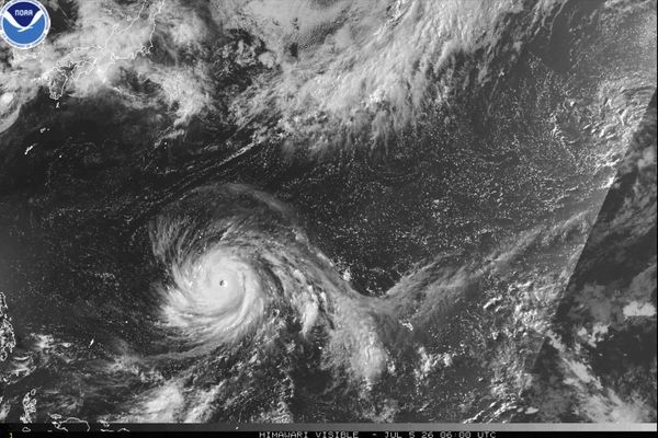
It was packing sustained winds of 110mph at 12am EDT on Wednesday, according to the National Hurricane Center, making it just 1mph shy of a Category 3 storm. In the same update, the NHC said Idalia was about 120 miles (195km) southwest of Cedar Key in Florida and about 175 miles (280km) south of Tallahassee, moving north at 17mph (27kph).
States of emergency have been declared in Florida, North and South Carolina and Georgia. Residents of vulnerable coastal areas in Florida have been ordered to evacuate, with governor Ron DeSantis warning: “You really gotta go now. Now is the time.” In total, 28 of the state’s 67 counties are under evacuation orders.
The National Weather Service in Tallahassee has called Idalia “an unprecedented event” since no major hurricanes on record have ever passed through the bay abutting the Big Bend, where the state’s northern panhandle curves into the Gulf side of the Florida Peninsula.
Surge warnings have been posted for hundreds of miles of shoreline, from Sarasota to the sport fishing haven of Indian Pass at the western end of Apalachicola Bay. In some areas, the surge of water could rise 12 to 16 feet, the hurricane center said.
Florida’s Gulf Coast along with southeastern Georgia and eastern portions of North and South Carolina could face torrential rains of 4 to 8 inches (10 to 20 cm) through Thursday, with isolated areas seeing as much as 12 inches (30 cm), the hurricane center also warned.
A tornado watch has also been issued for parts of Florida, including Tampa and Gainesville, and will remain in place until 6am EDT on Wednesday. The National Weather Service said those areas could also expect “isolated hail up to half inch size possible”.
US president Joe Biden said he and DeSantis were “in constant contact,” adding that he had assured the governor federal disaster assistance would remain in place for as “long as it takes, and we*ll make sure they have everything they need.”
Idalia also caused heavy rains in Cuba on Monday and Tuesday, leaving the tobacco-growing province of Pinar del Rio underwater. More than 10,000 people were evacuated to shelters or stayed with friends and relatives as up to 4 inches (10 centimeters) of rain fell. More than half of the province was without electricity.
Updated
The city of Tampa has warned that the storm surge of 4 to 6 feet expected in the area could hit after the hurricane’s core moves past:
#IDALIA UPDATE 🌀
— City of Tampa (@CityofTampa) August 30, 2023
⚠️ Tampa residents should prepare for storm surge to arrive AFTER the eye of the storm moves past our area.
⚠️ We could see 4-6FT of storm surge impacting areas like Bayshore Blvd, Westshore, and Port Tampa between 11AM-5PM Wednesday. pic.twitter.com/uHWZNEVFlk
About 4,000 inmates of Florida’s prisons have been evacuated or relocated to facilities “in an abundance of caution” ahead of Idalia’s arrival, the state’s Department of Corrections has said.
It said inmates from more than 40 facilities had been “relocated to larger main units (parent facilities), better equipped to weather the storm.”
It also said extra food and water supplies had been ordered for facilities in the path of the storm and that “fuel supplies at institutions have been checked in anticipation of generator use.”
Maintenance teams from other teams were also ready to deploy after the storm had passed, the department said.
The hurricane is now about 115 miles (185km) south-west of Cedar Key, Florida and 160 miles (255km) south of Tallahassee with maximum sustained winds of 110mph, the National Hurricane Center has said in its latest update.
The storm is moving north at 16mph (26km/h)
A bit of context: Idalia will be the first hurricane to strike Florida since Nicole in November 2022, which made landfall close to Vero Beach on Florida’s east coast.
The deadly storm packed winds of 75mph winds – considerably less than Idalia – and a storm surge that collapsed buildings into the ocean and swept away roads as far north as Daytona Beach.
At the storm’s height, 330,000 customers lost power, many in areas recovering from Hurricane Ian, which ravaged the state just two months earlier, killing almost 150 people.
Ian was the second-deadliest storm to hit the mainland US in the 21st century after Hurricane Katrina, which left more than 1,800 people dead in 2005.
The deadliest hurricane ever to hit the US was the Galveston Hurricane in 1900 that killed as many as 8,000 people.

Summary
If you’re just joining us, here’s a roundup of the key developments:
Hurricane Idalia is forecast to reach “an extremely dangerous Category 4 intensity” with maximum sustained winds of at least 130 mph (209 kph) before it is predicted to slam into the Big Bend region on Florida’s Gulf Coast early Wednesday.
It was packing sustained winds of 110mph at 12am EDT on Wednesday, according to the National Hurricane Center, making it just 1mph shy of a Category 3 storm. In the same update, the NHC said Idalia was about 120 miles (195km) southwest of Cedar Key in Florida and about 175 miles (280km) south of Tallahassee, moving north at 17mph (27kph).
States of emergency have been declared in Florida, North and South Carolina and Georgia. Residents of vulnerable coastal areas in Florida have been ordered to evacuate, with governor Ron DeSantis warning: “You really gotta go now. Now is the time.” In total, 28 of the state’s 67 counties are under evacuation orders.
The National Weather Service in Tallahassee has called Idalia “an unprecedented event” since no major hurricanes on record have ever passed through the bay abutting the Big Bend, where the state’s northern panhandle curves into the Gulf side of the Florida Peninsula.
Surge warnings have been posted for hundreds of miles of shoreline, from Sarasota to the sport fishing haven of Indian Pass at the western end of Apalachicola Bay. In some areas, the surge of water could rise 12 to 16 feet, the hurricane center said.
Florida’s Gulf Coast along with southeastern Georgia and eastern portions of North and South Carolina could face torrential rains of 4 to 8 inches (10 to 20 cm) through Thursday, with isolated areas seeing as much as 12 inches (30 cm), the hurricane center also warned.
A tornado watch has also been issued for parts of Florida, including Tampa and Gainesville, and will remain in place until 6am EDT on Wednesday. The National Weather Service said those areas could also expect “isolated hail up to half inch size possible”.
US president Joe Biden said he and DeSantis were “in constant contact,” adding that he had assured the governor federal disaster assistance would remain in place for as “long as it takes, and we*ll make sure they have everything they need.”
Idalia also caused heavy rains in Cuba on Monday and Tuesday, leaving the tobacco-growing province of Pinar del Rio underwater. More than 10,000 people were evacuated to shelters or stayed with friends and relatives as up to 4 inches (10 centimeters) of rain fell. More than half of the province was without electricity.
The National Hurricane Center has issued its 12am update, forecasting a “catastrophic storm surge and destructive winds” in the Florida Big Bend, where Idalia is predicted to make landfall early Wednesday.
The hurricane was still recording sustained winds of 110mph, making it just 1mph short of a Category 3 storm.
It is now about 120 miles (195km) southwest of Cedar Key in Florida and about 175 miles (280km) south of Tallahassee, moving north at 17mph (27kph).
It’s been interesting to watch radar of #Idalia’s eye over the last hour or two. Notice the polygonal shaped eye near the start of this loop, that becomes more circular towards then end.
— Eric Webb (@webberweather) August 30, 2023
This is likely due to eyewall mesovortices merging inside #Idalia’s eye. As these… pic.twitter.com/tmMR44q5BX
Residents can expect “catastrophic impacts” from storm surges of between 12 and 16 feet and destructive waves somewhere between the Wakulla/Jefferson County line and Yankeetown in Florida, the National Hurricane Center (NHC) said in its latest update.
There is also the potential for “destructive life-threatening winds” when the storm’s core moves onshore in the Big Bend, it said. Strong winds are also expected to spread inland across parts of northern Florida and southern Georgia.
The NHC warned that residents in these areas should be “prepared for long-duration power outages”.
Flash, urban and moderate river flooding with “locally considerable impacts” is expected in the Big Bend, central Georgia and South Carolina through eastern North Carolina into Thursday, it continued.
+ For the text version of the 11 pm EDT Key Messages for #Idalia, please see: https://t.co/0r2luuUO6G https://t.co/LnJcWUfZIf
— NOAA (@NOAA) August 30, 2023
A bit more from the latest National Hurricane Center update; the storm is now about 125 miles (200km) west of Tampa and 185 miles (300km) south of Tallahassee. It is travelling north at 18mph (30kph) with a minimum central pressure of 958mb.
Idalia to become 'extremely dangerous Category 4 intensity at landfall', hurricane center says
Hurricane Idalia is set to become an “extremely dangerous Category 4 intensity at landfall” the National Hurricane Center has said in its 11pm EDT update.
The storm, now a Category 2, was packing sustained winds of 110mph – 1mph away from being classified a Category 3 storm, the center said.
Updated
In its last update the National Hurricane Center said Idalia had reached maximum sustained wind speeds of 110mph, meaning it is just 1mph away from being declared a Category 3 storm. The next update is expected in just a few minutes.
NEW: The Hurricane Hunters just found flight-level winds of 110 knots (125 mph) in the eyewall of #Idalia.
— Matthew Cappucci (@MatthewCappucci) August 30, 2023
Surface winds were estimated at just over 105 mph. Idalia is teetering on the brink of Category 3 strength, and could get there by 11 p.m. pic.twitter.com/MLB2iyyQmv
Updated
Jamie Rhome of the National Hurricane Center has warned that people may be underestimating the power of the coming storm. He told PBS news:
If you have never experienced the power of a major hurricane, you’re probably underestimating just how strong it is …
The conditions are going to deteriorate rapidly through the evening and overnight areas in advance of this system.
We are already seeing heavy rain bands and strong winds move across the Florida Peninsula as we speak. This is no longer a sit and wait, sit and watch, or hope for a different outcome.
It is clear, if you’re in the path of this system, and most especially, most especially if you have been ordered to evacuate, you need to do that now, not tomorrow, now.
Separately, he told the BBC that a storm surge of 10-15ft (4.5m) could be “hard for a lot of people to fathom and envision”.
Rhome, who is 6ft tall, said people should try to imagine another one or more people standing on his shoulders to get a picture of the expected depth of some flood waters.
Summary
If you’re just joining us, here’s a roundup of the key developments:
Hurricane Idalia is forecast to reach Category 3 strength – classified as a major hurricane, with maximum sustained winds of at least 111 mph (179 kph) – before it is predicted to slam into the Big Bend region on Florida’s Gulf Coast early Wednesday. It was upgraded to a Category 2 storm late on Tuesday afternoon with winds strengthening to 105 mph (165 kph).
At 8 pm EDT Tuesday, Idalia was about 155 miles (250 kilometers) west-southwest of Tampa, the National Hurricane Center said. It was moving north at 16 mph (26 kph)
States of emergency have been declared in Florida, North and South Carolina and Georgia. Residents of vulnerable coastal areas in Florida have been ordered to evacuate, with governor Ron DeSantis warning: “You really gotta go now. Now is the time.” In total, 28 of the state’s 67 counties are under evacuation orders.
The National Weather Service in Tallahassee has called Idalia “an unprecedented event” since no major hurricanes on record have ever passed through the bay abutting the Big Bend, where the state’s northern panhandle curves into the Gulf side of the Florida Peninsula.
Surge warnings have been posted for hundreds of miles of shoreline, from Sarasota to the sport fishing haven of Indian Pass at the western end of Apalachicola Bay. In some areas, the surge of water could rise 10 to 15 feet (3.0 to 4.6 m), the hurricane center said.
Florida’s Gulf Coast along with southeastern Georgia and eastern portions of North and South Carolina could face torrential rains of 4 to 8 inches (10 to 20 cm) through Thursday, with isolated areas seeing as much as 12 inches (30 cm), the hurricane center also warned.
A tornado watch has also been issued for parts of Florida, including Tampa and Gainesville, and will remain in place until 6am EDT on Wednesday. The National Weather Service said those areas could also expect “isolated hail up to half inch size possible”.
US president Joe Biden said he and DeSantis were “in constant contact,” adding that he had assured the governor federal disaster assistance would remain in place for as “long as it takes, and we*ll make sure they have everything they need.”
Idalia also caused heavy rains in Cuba on Monday and Tuesday, leaving the tobacco-growing province of Pinar del Rio underwater. More than 10,000 people were evacuated to shelters or stayed with friends and relatives as up to 4 inches (10 centimeters) of rain fell. More than half of the province was without electricity.
More than 30,000 utility workers have been gathering to make repairs as quickly as possible in the Idalia’s wake.

And about 5,500 National Guard troops have been activated.
And there it is - the tiny pinhole eye of #Idalia emerging.
— Ian Oliver (@IanOliverWX) August 30, 2023
Small inner core is more prone to rapid strengthening. That eye is about 125 miles WSW of the mouth of Tampa Bay on a course for the Big Bend as a major. @foxweather pic.twitter.com/LWQD1emanZ
A rare blue supermoon could worsen the effects of Hurricane Idalia, experts have told Sky News, by making high tides and higher and flooding potentially worse.
“I would say the timing is pretty bad for this one,” Brian Haines, the meteorologist in charge at the National Weather Service office in Charleston, South Carolina, said.
King tides are higher-than-normal tides that are caused by the extra gravitational pull of the moon and sun, usually during a new or full moon.
The blue supermoon will be closest to Earth on Wednesday night US time, when parts of Charleston could be underwater according to Haines.

Many school districts as well as several colleges and universities have cancelled classes and closed campuses through Wednesday due to the approaching storm.
The University of Central Florida in Orlando urged staff and students to “remain indoors and off the roads” while the University of North Florida in Jacksonville said students were “advised to avoid any outdoor activity tomorrow”. Classes were expected to resume as normal on Thursday at both universities.
Florida State University in Tallahassee has said its campus will be closed through Friday.
Academic and most campus operations are suspended Wednesday, Aug. 30. Students, faculty, and staff should remain indoors and off the roads during periods of possible intermittent tropical winds and weather. https://t.co/76ImhCDVpb#UCFAlert pic.twitter.com/0WPzFiUZGR
— UCF (@UCF) August 29, 2023
This is Helen Livingstone taking over the blog from my colleague Lois Beckett.
Tornado watch issued for parts of Florida, including Tampa and Gainesville
It’s official:
A tornado watch has been issued for parts of Florida until 6 AM EDT pic.twitter.com/QnqruTvWSm
— NWS Tornado (@NWStornado) August 30, 2023
As residents evacuate Florida’s Cedar Key, some B&B owners are staying put
As local and state officials implore residents to evacuate from areas in Idalia’s path, some are staying put, including some B&B owners and staff on the picturesque island town of Cedar Key.
-
CNN reports that Heather Greenwood, the manager of Cedar Key Bed & Breakfast, said she “not only wanted to provide a place for news crews to stay but wanted to help others she knows are staying in town.
“I’m here and I’m available to help them as much as I can,” she told CNN, noting that “the house is at the highest point on the island and has been secured”, and that she had filled all the bathtubs with water.
-
Meanwhile, Andy Bair, owner of the Island Hotel in Cedar Key, told the Associated Press that he intended to “babysit” his bed-and-breakfast, which predates the civil war. The building has not flooded in the almost 20 years he has owned it, not even when Hurricane Hermine flooded the city in 2016, he said.
“Being a caretaker of the oldest building in Cedar Key, I just feel kind of like I need to be here,” Bair said. “We’ve proven time and again that we’re not going to wash away. We may be a little uncomfortable for a couple of days, but we’ll be OK eventually.”
Updated
Idalia ‘likely to become a major hurricane soon’, tornado watch expected in Florida
The latest update from the National Hurricane Center suggests that Idalia will likely soon become a “major hurricane”, defined by the center as a category 3 or above, with winds of 111mph or higher.
Hurricane #Idalia Advisory 13A: Idalia Continues to Strengthen. Likely to Become a Major Hurricane Soon. https://t.co/tW4KeGe9uJ
— National Hurricane Center (@NHC_Atlantic) August 29, 2023
But for now, as WeatherNation reports, it’s still a category 2.
Meanwhile, meteorologists are reporting that a tornado watch will likely be issued for parts of Florida.
NEW: A #tornado watch will likely be issued for western Florida south of Gainesville as #Idalia approaches.
— Matthew Cappucci (@MatthewCappucci) August 29, 2023
Increasing low-level helicity, or twist, will help individual cells within Idalia's spiral rain bands to rotate thanks to changing winds with height. pic.twitter.com/2tx5EEer5J
There’s already dramatic footage from earlier today in Florida:
🌪👀🌪
— Greg Rule (@WXRules) August 29, 2023
WOW!
Hurricane Idalia producing multiple vortices this afternoon near 2 PM in Boca Brande.
Can’t tell if they reached the surface, but nonetheless, impressive!
All due to Hurricane Idalia swirling off the SW Florida coast.
📸: Milagros Rivera@winknews @NWSTampaBay pic.twitter.com/BpOYLjy2kD
Updated
Idalia headed for ‘one of the last truly natural places’ in Florida
If you’re reading about Hurricane Idalia’s path, and wondering what exactly Florida’s ‘Big Bend’ region is, the Associated Press has more detail:
Florida’s Big Bend is one of the last truly natural places in the state. It’s not Disney World, it’s not South Beach. This is where people go to hunt alligators, fish for tarpon and search for scallops in the shallow waters …
The Big Bend is where the peninsula merges into the Panhandle, just southeast of the capital, Tallahassee, and well north of the Tampa metro area. Hurricane Idalia would be the first major storm to hit there since Hurricane Easy in 1950, according to the National Hurricane Center.
This is where people go to appreciate nature and be left alone.
… The National Weather Service in Tallahassee called Idalia “an unprecedented event” since no major hurricanes on record have ever passed through the bay abutting the Big Bend region.
Updated
Evacuated plane in Florida records St Elmo’s fire: report
In Tampa, Florida, a plane being evacuated from an air force base recorded the eerie purple flicker of St Elmo’s fire or Witch’s fire, AccuWeather reports:
A plane being evacuated from MacDill Air Force Base in Tampa, FL due to Hurricane #Idalia recorded St. Elmo's Fire, a lightning-like weather phenomenon which is a coronal discharge of plasma. pic.twitter.com/wPJcNtNfjP
— AccuWeather (@accuweather) August 29, 2023
Updated
What makes Idalia so potent? ‘Absurdly warm’ water that acts ‘like rocket fuel’
Hurricane Idalia is expected to gain strength as it approaches Florida and the rest of the Gulf Coast, and scientists told the Associated Press the storm is being supercharged by the high temperatures of ocean water.
“It’s 88, 89 degrees (31, 32 degrees Celsius) over where the storm’s going to be tracking, so that’s effectively rocket fuel for the storm,” said Colorado State University hurricane researcher Phil Klotzbach. “It’s basically all systems go for the storm to intensify.”
That water “is absurdly warm and to see those values over the entire northeast Gulf is surreal,” said University of Miami hurricane researcher Brian McNoldy.
Idalia “stands a chance of setting a record for intensification rate because it’s over water that’s so warm,” said MIT hurricane professor Kerry Emanuel. On Tuesday, only a few places on Earth had conditions — mostly warm water — so primed for a storm’s sudden strengthening, he said.
“Hurricanes get their energy from warm water,” the Associated Press’s Seth Borenstein writes, meaning Idalia is currently “at an all-you-can-eat buffet”.
Updated
Florida 'already seeing impacts' of Idalia in south-west, says Ron DeSantis
The Florida governor Ron DeSantis advised people under evacuation orders to “make decisions that are best for you and for your family”.
The National Hurricane Center has warned that “life-threatening” high tide storm surge could reach 10 to 15ft in some areas of the Big Bend. DeSantis said:
If you’re there while that hits, it’s going to be very difficult to survive that – so please take appropriate precautions.
He added:
We are already seeing impacts in southwest Florida. […] The eye of the storm is probably 100 miles or more off the coast of southwest Florida, and yet those outer bands are already showing significant impacts. So you’re gonna see impacts all up and down the west coast of Florida as the night goes on and as we get in to the wee hours of tomorrow morning.
DeSantis urged everybody to “hang in there” and warned the storm will lead to “significant impacts”, particularly in this part of the state.
Be prepared for that. Be prepared to lose power and just know that there’s a lot of folks that are going to be there to help you get back on your feet.
Updated
Florida governor Ron DeSantis urges residents under evacuation orders to leave now
Ron DeSantis has been speaking at another news conference as the state braces for Idalia to make landfall.
The hurricane is now about 190 miles (305km) south-west of Tampa and is intensifying, DeSantis said. There will be a “significant impact” on the Big Bend region, especially in low-lying and coastal areas, “so please prepare for that”, he said.
He urged residents under evacuation orders issued by 28 counties not to wait any longer, noting the high storm surge expected on parts of the coast.
If you are in evacuation zone and you’ve been directed to evacuate […] now’s the time to do it. You still have a little bit more time. If you wait much longer, by the time we get in further into tonight, the weather is going to start getting nastier and nastier.
DeSantis said it would be “too nasty” for people to leave tomorrow morning, and that first responders would not be able to reach them until after the storm had passed.
Updated
Hurricane Idalia is projected to come ashore early Wednesday as a category 3 storm – classified as a major hurricane – with sustained winds of up to 120mph (193 km/h) in the lightly populated Big Bend region, where the Florida panhandle curves into the peninsula.
The National Weather Service in Tallahassee has called Idalia “an unprecedented event” since no major hurricanes on record have ever passed through the bay abutting the Big Bend.
At 5pm ET, Idalia was about 195 miles (310km) southwest of Tampa, the National Hurricane Center said. It was moving north at 16mph (26 km/h).
Updated

Idalia to bring 'catastrophic' impacts from storm surge
Idalia strengthened into a category 2 hurricane with maximum winds of 100mph, as forecasters warned of life-threatening winds and a catastrophic storm surge.
A storm surge of up to 15ft in some locations, destructive winds up to 125mph and a risk of significant flooding are all forecast, according to the National Hurricane Center.
Forecasters said the storm is expected to make landfall somewhere in Florida’s Big Bend region, a sparsely populated area where the panhandle meets the peninsula.
5PM EDT 29 Aug: #Idalia to bring catastrophic impacts from storm surge inundation . Residents in these areas should follow any advice or evacuation orders given by local officials. Make sure to stay informed with latest updates at https://t.co/tW4KeGe9uJ pic.twitter.com/jYnbfkkcyS
— National Hurricane Center (@NHC_Atlantic) August 29, 2023
Updated
President Joe Biden said he spoke with Florida governor, Ron DeSantis, on Monday night about preparations for Hurricane Idalia and said the administration was “providing everything he possibly needs”.
He added that officials were worried about storm surge, which is predicted to reach 15ft as the storm lashes the Gulf coast. He added that the administration is monitoring the storm on an hourly basis.
“We’re there as long as it takes,” Biden said he told DeSantis during their conversation.
Updated
National Hurricane Center declares Idalia a category 2 hurricane
Idalia has strengthened into a category 2 hurricane, with maximum sustained winds of 100mph, the National Hurricane Center said.
Forecasters warned “life-threatening storm surge and hurricane conditions” are expected along portions of Florida’s Gulf coast tonight and Wednesday.
Hurricane #Idalia Advisory 13: Idalia Now a Category 2 Hurricane. Life-Threatening Storm Surge and Hurricane Conditions Expected Along Portions of the Gulf Coast of Florida Tonight and Wednesday. https://t.co/tW4KeGe9uJ
— National Hurricane Center (@NHC_Atlantic) August 29, 2023
Updated
Florida governor Ron DeSantis warned residents in inland counties will also see “significant impacts” of Hurricane Idalia.
Speaking at a news conference, DeSantis said parts of the coast would experience “really significant storm surge” and urged people in those areas to evacuate.
You still have time to do that if you are in this Big Bend area, but time is running out very very rapidly.
Local officials in Savannah, Georgia, are considering issuing a 6pm curfew after a local state of emergency order was signed by the mayor.
The curfew is not in place yet, WTOC-TV reported, despite Mayor Van Johnson posting to X that it would be in effect from 6pm Wednesday until 6am Thursday.
Pursuant to my emergency order issued today and in the safety interests of our citizens and first responders, a curfew will be set in #Savannah beginning 6pm tomorrow (Wednesday) night until 6am Thursday.
— Mayor Van Johnson (@MayorJohnsonSAV) August 29, 2023
Be safe, be smart, stay home! pic.twitter.com/wwdO3B3BrA
Extreme weather 'is our new normal', says Fema chief
The head of the Federal Emergency Management Agency (Fema), Deanne Criswell, urged residents in the path of Hurricane Idalia to heed warnings from local officials and to take the storm “seriously”.
Criswell, at a White House press conference, described the “unprecedented” number of disaster requests from governors due to extreme weather events this year. She added:
This is the new normal.
The storm surge from Idalia will likely be “one of the highest-risk parts” of the hurricane and threatens to wreak havoc along the west coast of Florida, Criswell said.
Very few people can survive being in the path of major storm surge, and this storm will be deadly if we don’t get out of harm’s way and take it seriously.
She said she spoke on Monday with governors Ron DeSantis of Florida, Brian Kemp of Georgia and Henry McMaster of South Carolina to coordinate on the hurricane and work with the states on their needs.
Hurricane Idalia remained a category 1 hurricane but its maximum sustained winds increased to 90mph as of 2pm Eeastern time, the National Weather Service said in its latest update.
The update reads:
Satellite images indicate that Idalia continues to strengthen, and maximum sustained winds have increased to near 90 mph (150 km/h) with higher gusts. Rapid intensification is expected before landfall, and Idalia is forecast to be a major hurricane when it reaches the Gulf coast of Florida Wednesday morning.
Updated
Here are some of the latest images from the newswires showing the aftermath of Idalia in Cuba, where the storm downed trees, caused widespread flooding and knocked out electricity.
In Pinar del Río, Cuba’s westernmost province, around 60% of the population was without electricity, state media reported.


Ken Graham, the director of the National Weather Service, tweeted on Tuesday morning that “time is running out” for people to prepare for Hurricane Idalia. He added:
This hurricane could very well join the extensive list of storms starting with the letter I that have been especially destructive.
Time is running out to prepare for Idalia! Follow the urgent advice from local officials. This hurricane could very well join the extensive list of storms starting with the letter I that have been especially destructive. pic.twitter.com/GjryWUCnl1
— NWS Director (@NWSDirector) August 29, 2023
State of emergency issued in North and South Carolina
North Carolina and South Carolina have each declared a state of emergency ahead of potential impacts from Hurricane Idalia.
The North Carolina governor, Roy Cooper, declared the emergency on Monday “to activate the state’s emergency operations plan, waive transportation rules to help the transport of fuel and critical supplies and services, help first responders and assist the agriculture industry to prepare in advance for inclement weather and protect consumers from price gouging”, a statement from his office said.
“We are continuing to monitor Idalia’s course and its potential impacts on our state and it’s critical to make sure we are fully prepared,” Cooper said.
It is important for North Carolinians to gather emergency kits and prepare for the storm before it’s too late. We also want to make sure our farmers are able to protect their crops.
South Carolina’s governor, Henry McMaster, declared the emergency on Tuesday, warning that although the state “may avoid the worst of Hurricane Idalia’s impacts”, residents should be “making proper preparations” and authorities would ensure to have “the necessary resources in place to respond to flooding events and are able to respond quickly if the forecast worsens”, Fox reported.
A state of emergency has also been issued for Georgia.
Updated
Florida officials are requesting a major disaster declaration from the federal government ahead of Idalia, NBC reports.
Governor Ron DeSantis announced the development during a press conference on Tuesday, adding that the request will be made today.
“It’s our belief that that will be approved based on our conversations with Fema,” DeSantis said at the Tuesday press conference.
Updated
Weather forecasters have also noted that tornadoes are possible in several areas of Florida, as the state prepare for Idalia.
Tornado warnings are still active in Collier county, Florida until 2.45pm eastern time (6.45pm GMT).
Tornado Warning continues for Collier County, FL until 2:45 PM EDT pic.twitter.com/j2nEI95DPS
— NWS Tornado (@NWStornado) August 29, 2023
The warning covers cities including Naples, Florida, Golden Gate, Florida, and other south-west cities.
Tornado Warning continues for Golden Gate FL, Naples Park FL and North Naples FL until 2:45 PM EDT pic.twitter.com/KKHwuTMGAs
— NWS Tornado (@NWStornado) August 29, 2023
Updated
Idalia currently has winds of 90mph, according to forecasters, as the storm is expected to become a category 3 hurricane before it makes landfall on Wednesday.
Hurricane #Idalia Advisory 12A:
— Weather Track US (@weathertrackus) August 29, 2023
Idalia strengthens to 90mph this afternoon, still forecast to reach high-end Category 3 status before landfall in the Big Bend of #Florida on Wednesday morning.#flwx #tropics pic.twitter.com/Ui2uXAykex
Updated
Residents in Florida are preparing for the potential impact of Idalia, which is expected to beef up further in strength and size during Tuesday and crash ashore as a higher-end category 3 hurricane on Wednesday.
Idalia would be the first hurricane to strike Florida since Nicole in November 2022, and the first major cyclone of category 3 or greater since Hurricane Ian ravaged the south-west of the state and killed almost 150 people last September.


Updated
The forecast for Hurricane Idalia’s path shifted slighly westward, increasing in changes for impacts across inland Georgia, especially for south-east central Georgia, according to the National Weather Service.
Lots of updates related to Hurricane Idalia incoming. Bottom line: subsequent shifts of the forecast track slightly westward have increased chances for impacts across inland Georgia, especially for southeast central Georgia. A thread 🧵: #gawx pic.twitter.com/823irZqg51
— NWS Atlanta (@NWSAtlanta) August 29, 2023
Updated
Georgia governor declares state of emergency
Georgia’s governor, Brian Kemp, has issued a state of emergency for the entire state in preparation for Hurricane Idalia’s anticipated impact on Wednesday.
The order went into effect on Tuesday and will expire on 8 September, a statement by the governor said.
“We are taking every precaution ahead of Hurricane Idalia’s landfall tomorrow, and I am taking this additional executive action to ensure state assets are ready to respond.
Georgians in the expected impact area can and should take necessary steps to ensure their safety and that of their families. We are well positioned to respond to whatever Idalia may bring.
The hurricane is expected to move through Georgia on Wednesday, bringing heavy rainfall and damaging winds throughout the south-east of the state. Tropical storm and hurricane warnings are now in effect for counties in south-east Georgia.
Updated
Hurricane Idalia tracker: when and where will it hit?
A rapidly intensifying Hurricane Idalia was closing in on Florida’s Gulf coast on Tuesday, with landfall of the first major hurricane to strike the US this year was expected early on Wednesday.
Forecasters predicted Idalia would crash ashore as a higher-end category 3 hurricane. Category 3 hurricanes have winds between 111 and 129mph. Anything above a category 2 – on a scale of up to 5 – is considered major.
On the island of Cedar Key off the north-west coast of Florida, city commissioner Sue Colson said she expected Idalia to be the worst storm she has seen in her 32 years of living there.
Colson had a message for the almost 900 residents who were under mandatory orders to evacuate the island near the coast of the Big Bend region, AP reported.
One word – leave. It’s not something to discuss.
More than a dozen state troopers went door to door warning residents that storm surge could rise as high as 15ft (4.5 meters).
“This is a very, very serious storm,” the Wall Street Journal quoted Colson as saying on Tuesday morning.
Two blocks this way, two blocks that way, two blocks that way. Water. And all the other little residential areas are connected by bridges. Any one of those bridges can be taken out. If they do, you’re stuck on your side.
Updated
Florida issues state of emergency for 49 counties
A state of emergency has been issued for 49 Florida counties as Hurricane Idalia, which is expected to rapidly strengthen into a major category 3 hurricane, approaches the Sunshine state.
Florida governor Ron DeSantis announced on Tuesday that a previous executive order was amended and an additional three counties have been added to the state of emergency declaration – Brevard, Orange and Osceola.
Governor Ron DeSantis Gives Update on Hurricane Idalia From Wildwood Florida https://t.co/nHdRvPr0DA
— Ron DeSantis (@GovRonDeSantis) August 29, 2023
Updated
As Floridians brace for Idalia’s arrival, Cubans were grappling with the aftermath of the storm which had made landfall in the western tip of the Caribbean island nation on Monday, shortly before it was expected to intensify into a hurricane.
By Monday afternoon, brown flood waters had swamped the small fishing village of Guan, an hour’s drive south of Havana, Reuters reported.
Strong winds and rain persisted on Tuesday morning, one resident said.
Fallen trees are blocking roads. There are power lines on the streets, which are covered with leaves and branches, and homes in many towns have lost roofs. Unfortunately, once again, it is a sad panorama for our city.


The Federal Aviation Administration (FAA) is re-routing planes and closing Gulf routes as the storm is expected to make landfall in the Florida region on Wednesday morning.
The FAA is re-routing aircraft and closing Gulf routes as Hurricane #Idalia is expected to hit the Florida region Wednesday morning. We may pause flights in and out of @flyPBI, @iflymia and @FLLFlyer to keep you safe. Monitor https://t.co/smgdqJNBiL. #FAAWeatherSquad pic.twitter.com/xkwSDMsuGy
— The FAA ✈️ (@FAANews) August 29, 2023
Hundreds of flights canceled as Florida airports close for Idalia
The predicted landfall of Hurricane Idalia as category 3 hurricane on Florida’s northwest coast led to significant disruptions, with thunderstorms and strong winds expected to impact several airports in the area.
Tampa international airport was closed on Tuesday, resulting in hundreds of flight cancellations. The airport said it expected to reopen on Thursday morning.
🚨 TPA TO CLOSE DUE TO IDALIA 🚨
— Tampa International Airport ✈️ (@FlyTPA) August 28, 2023
🫡 We will close at 12:01 AM Tuesday
✈️ Check directly with your airline for the latest flight updates
⛈️ TPA is not a shelter
📱 Stay tuned to our social media for the latest
MORE DETAILS ➡️ https://t.co/MXZKAusjzW pic.twitter.com/m6nGbNdul3
St Pete-Clearwater international airport said it would close Tuesday 3pm local time, with plans to reopen on Wednesday at 3pm.
PIE will close 3:00 pm on Tuesday, August 29th due to Tropical Storm Idalia and plans to reopen Wednesday, August 30th at 3:00 pm. Passengers should check with their airline for flight information updates.
— St. Pete-Clearwater International Airport (@iflypie) August 28, 2023
Updated
Idalia has strengthened with catastrophic storm surge expected in the Big Bend region, forecasters at the National Hurricane Center said in their latest update at 11am eastern time.
The area, roughly between the inland cities of Tallahassee and Gainesville, is much more lightly populated than the Tampa-St Petersburg area to the south.
11 AM EDT 29 Aug #Idalia strengthens, with catastrophic storm surge expected in the Big Bend region. Residents in these areas should follow any advice or evacuation orders given by local officials. Make sure to stay informed with latest updates at https://t.co/tW4KeGe9uJ pic.twitter.com/MkORCjjpi6
— National Hurricane Center (@NHC_Atlantic) August 29, 2023
Updated
The storm became a category 1 hurricane overnight and was expected to beef up further in strength and size during the day Tuesday, officials at the National Hurricane Center in Miami cautioned.
“The stage is set for Idalia to rapidly intensify before landfall,” specialist Eric Blake wrote in a morning update.
Combined with extremely warm and deep waters the hurricane will be traversing … confidence is increasing in an extremely dangerous major hurricane making landfall Wednesday along the west coast or Big Bend region of Florida.
A shift in Idalia’s predicted path moved the core of the hurricane farther north from the heavily populated Tampa Bay area, but residents were warned not to focus solely on the storm’s wind field.
“The number one killer in all of these storms is water, whether it’s the storm surge that’s going to happen at the coast, or the excessive rainfall that might happen inland that causes urban flash flooding,” Deanne Criswell, administrator of the Federal Emergency Management Agency (Fema), said on CNN Tuesday morning.
I want to tell everybody in Florida – listen to your local officials. If they asked you to evacuate, please do so, and it doesn’t mean you have to go hundreds of miles. It could just be 10 or 20 miles inland to get out of that main area.
A storm surge of up to 12ft was expected between the Chassahowitzka national wildlife refuge and the Aucilla River, a swampy, low-lying coastal region of the state. A surge greater than three feet was predicted as far south as Tampa.
After crossing northern Florida during Wednesday, the storm will head for Georgia and the Carolinas, where a stretch of the coast was placed under a tropical storm warning early Tuesday.
Updated
More than 20 Florida counties issue evacuation orders
More than 20 counties in western and Central Florida have issued evacuation orders ahead of Hurricane Idalia’s expected landfall on Wednesday morning, including parts of Tampa, the state’s third-largest city.
The counties that have issued mandatory evacuation orders are:
Citrus county
Dixie county
Franklin county
Gulf county
Lafayette county
Levy county
Pasco county
Pinellas county
Suwannee county
Taylor county
Wakulla county
The counties under voluntary evacuation orders or advised residents to evacuate are:
Alachua county
Baker county
Gilchrist county
Hillsborough county
Jefferson county
Hernando county
Madison county
Manatee county
Marion county
Nassau county
Sarasota county
Sumter county
Union county
Volusia county
Updated
Hurricane Idalia closes in on Florida as residents race to evacuate
Hello and welcome. A rapidly intensifying Idalia grew to hurricane strength early on Tuesday and is expected to make landfall on Florida’s Gulf coast on Wednesday, as residents in more than a dozen counties rushed to evacuate amid warnings of a life-threatening storm surge and destructive 120mph (193km/h) winds.
Idalia threatens to develop into an “extremely dangerous major hurricane” and lash the Gulf coast, with flash flooding and urban flooding also likely, the National Hurricane Center said. It currently remains a category 1 hurricane for now, but is expected to undergo rapid intensification and become an extremely dangerous category 3 hurricane before landfall on Wednesday.
The storm’s path is expected to impact a wide central portion of the state, including cities such as Tampa and Orlando, and move close to the Carolina coastline on Thursday, the National Hurricane Center said.
“You still have time this morning to make your final preparations ... but you gotta do that now,” the Florida governor, Ron DeSantis, announced at the state’s emergency operations center.
DeSantis on Monday placed 46 of Florida’s 67 counties under an emergency declaration, and Joe Biden signed a federal order freeing up personnel and resources, including Fema search and rescue teams.
We’ll bring you the latest news from the hurricane as it comes.