Hurricane Erin moved northeast after battering several East Coast states with coast flooding and “life-threatening” rip tides.
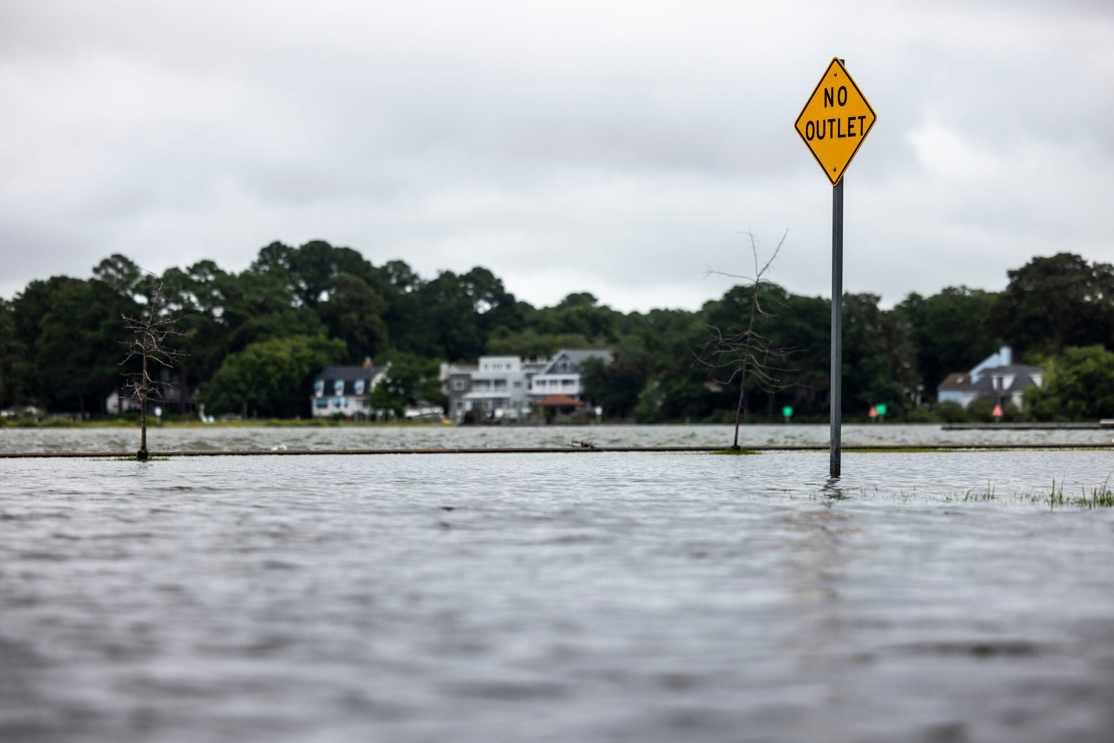
New Jersey Governor Phil Murphy issued a state of emergency on Thursday in preparation for the storm, which brought coastal flooding and hazardous surf conditions to the region. Crews rescued at least 50 people from cars, bars and restaurants on Thursday night amid flooding in Margate City, which is situated on the Jersey Shore, ABC 6 reports.
This comes after Hurricane Erin hit North Carolina's Outer Banks with strong winds and waves.
Several areas along the East Coast issued swim bans through Friday, including New York City.
The hurricane first formed on August 11 from a tropical wave that moved across the Cape Verde Islands and intensified rapidly.
Key Points
- Hurricane winds affect New Jersey coast amid state of emergency
- Erin pulls away but dangerous surf to persist along East Coast, says NHC
- Atlantic braces for new storms
What to know about Hurricane Erin
16:32 , Katie HawkinsonHurricane Erin has caused coastal flooding and “life-threatening” rip currents on the East Coast this week.
The storm is now moving away from the U.S., but it will still produce hazardous conditions along the East Coast.
Here’s what you need to know:
- Hurricane Erin was downgraded to a Category 1 storm on Friday.
- Hurricane Erin will still produce “life-threatening surf and rip currents along the beaches of the Bahamas, much of the east coast of the U.S., Bermuda, and Atlantic Canada during the next several days,” the National Hurricane Center said on Friday.
- The mid-Atlantic and New England regions will continue to see coastal flooding through Friday night.
- Swimming bans are in effect at New York City beaches through Friday.
End of coverage
20:01 , Graig GraziosiThe liveblog covering Hurricane Erin is now closed.
Stick with The Independent for more news.
Mapped: Hurricane Erin's winds over the next five days
19:10 , Katie Hawkinson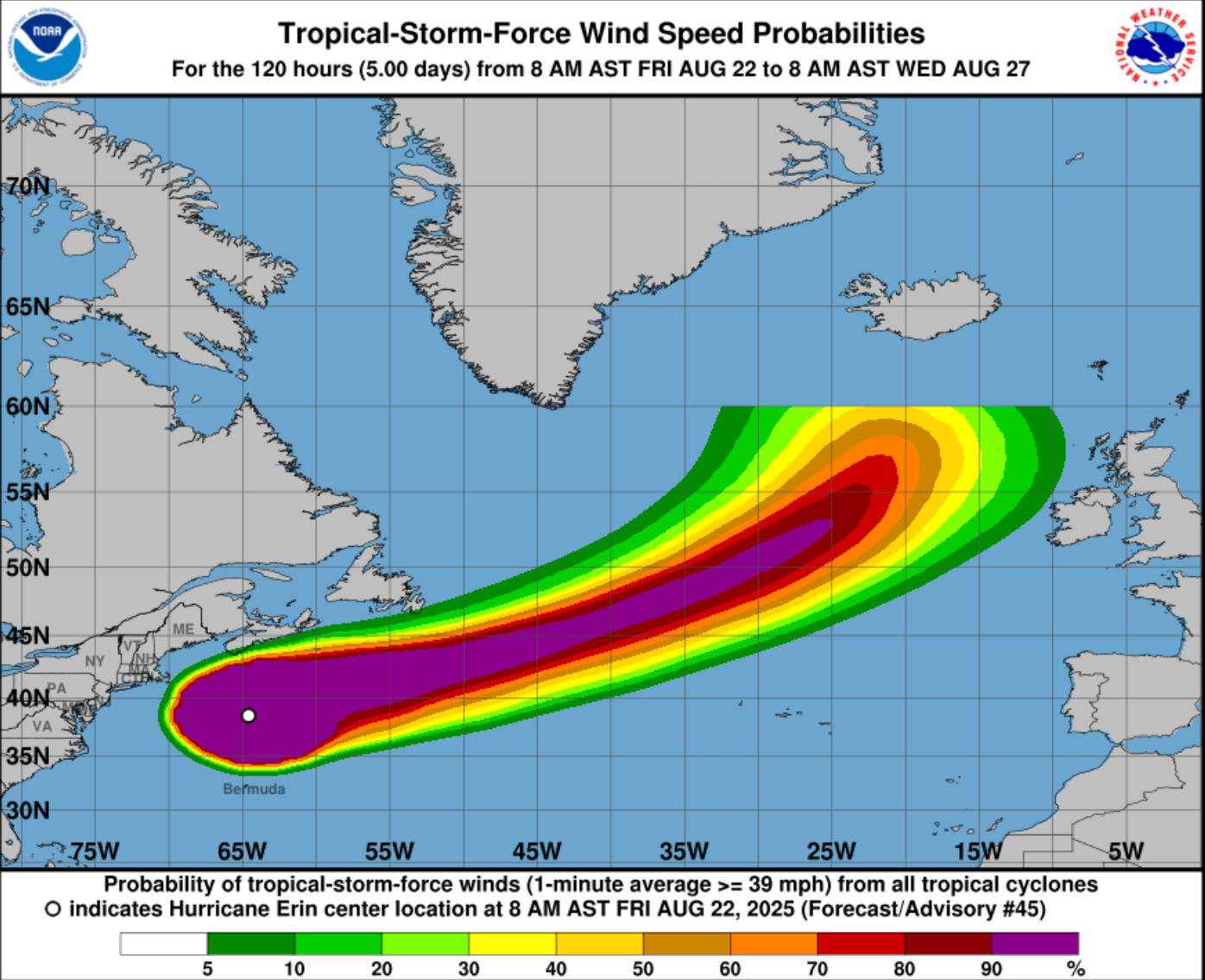
Watch: Forecasters watching the potential for two more storms after Hurricane Erin
18:16 , Katie HawkinsonWatch: Hurricane Erin batters Maryland coast
17:07 , Katie Hawkinson‘The threat of rip currents remain’
16:00 , Joe SommerladThis was the scene on Rockaway Beach in New York this morning.
Hurricane Erin batters the East Coast with heavy winds and towering swells along the coastline. @Morganorwood reports the latest. pic.twitter.com/0ofEFhT4kS
— Good Morning America (@GMA) August 22, 2025
Swim bans in NYC extended as 'life-threatening' rip currents persist
15:32 , Katie HawkinsonEven as Hurricane Erin moves away from the East Coast, “life-threatening” rip currents are still possible over the next several days, the National Hurricane Center said.
This comes as officials in several areas issue swim bans and warn people to stay out of ocean waters.
New York City extended its swim ban through Friday, while New Jersey Governor Phil Murphy warned residents to stay out of the water earlier this week.
Mapped: Hurricane Erin's expected path
15:28 , Katie HawkinsonThe National Hurricane Center released a map of Hurricane Erin’s predicted path over the next several days.
The storm is forecasted to weaken into a post-tropical storm over the next 24 hours, the National Hurricane Center said.

In pictures: Hurrican Erin floods Norfolk, Virginia
14:43 , Katie Hawkinson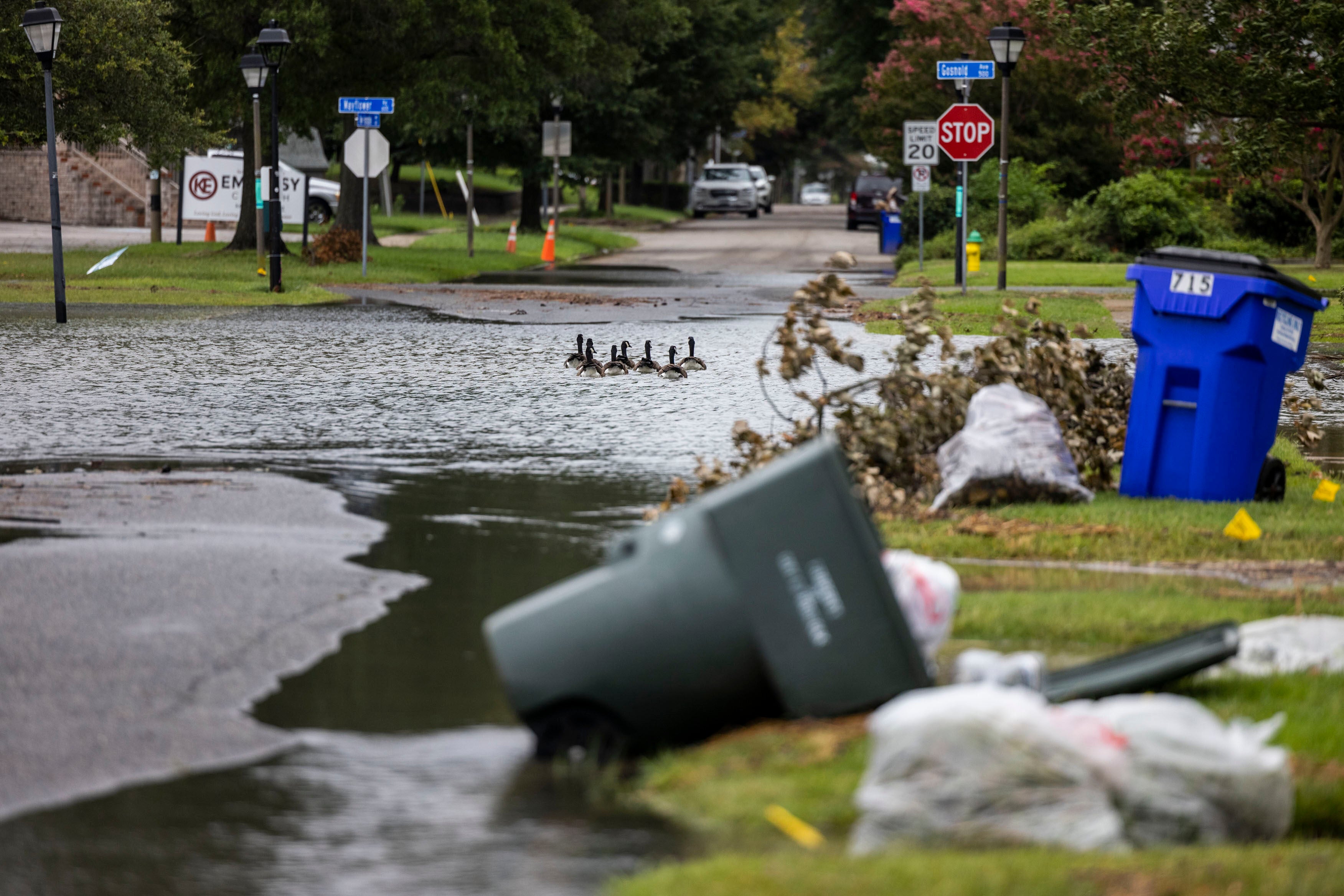
Bermuda calls time on Hurricane Erin
14:15 , Joe SommerladThe Bermuda government has said that the danger posed by this week’s tropical storm has now passed it by.
However, it says it is still tracking “two additional systems in the Atlantic with potential for cyclone development.”
Good Morning #Bermuda - The Tropical Storm warning has ended 🌀⚠️
— Bermuda Government (@BdaGovernment) August 22, 2025
As of the 6am BWS update (Aug. 22), Hurricane Erin is no longer a threat to the island. However, the sea states remain hazardous into the start of this weekend.
BWS is currently tracking two additional systems… pic.twitter.com/ORnvfIz4wh
New Jerseyites warned of flooding, 50mph winds and 17ft waves
13:30 , Joe SommerladIn announcing his state of emergency declaration for 21 counties yesterday, New Jersey Gov. Phil Murphy said:
“Over the past couple of days, we have seen the effects of Hurricane Erin along the Jersey Shore in the form of dangerous rip tides. Today and tomorrow will be no exception.
“As the storm moves past New Jersey over the next 24 hours, we are expecting high surf and rip currents, coastal and flash flooding, and a high erosion risk in parts of the state. We ask all New Jerseyans to monitor local weather forecasts and warnings and stay informed on evacuation protocols, especially if you’re down the Shore.”
With this evening’s high tide, there is the potential for major flooding along the Shore.
— Governor Phil Murphy (@GovMurphy) August 21, 2025
We are urging residents to move vehicles from flood prone streets and lots. Back bay communities and barrier islands should prepare for water swells and slower drainage.
Satellite imagery captures Erin from above
12:45 , Joe SommerladThe sheer size of the Atlantic storm at its peak has been extraordinary.
The epic size of Hurricane Erin. pic.twitter.com/DsdFdCTAt4
— Nahel Belgherze (@WxNB_) August 20, 2025
Hurricane Erin is absolutely beautiful. pic.twitter.com/qe48gZQ2cr
— Met4Cast (@Met4CastUK) August 20, 2025
Social media users post videos of huge waves and choppy conditions driven by Erin
12:00 , Joe SommerladDespite the official warnings, people appear to have been taking serious risks to try the surf.
Hurricane Erin swell on Nantucket’s south shore this morning 💣 pic.twitter.com/zayOMRbLX9
— Nantucket Current (@ACKCurrent) August 21, 2025
Hurricane 🌀 Erin turning New Jersey into Hawaii today ❤️ https://t.co/FdlR6ECufa pic.twitter.com/YEgWGQ1J88
— Wake Up NJ 🇺🇸 New Jersey (@wakeupnj) August 21, 2025
I am currently on Long Island, and I can report that #HurricaneErin, although roughly 900 miles way, has nonetheless wiped out the beaches on the east end.
— Dr. Genevieve Guenther (she/they) (@DoctorVive) August 21, 2025
1/n pic.twitter.com/ShayJdqaOT
Erin’s northeastward drift revealed in latest updates
11:15 , Joe SommerladHere’s ABC’s New York meteorologist to show us where the storm is headed this weekend.
Here's the latest track for Hurricane Erin. pic.twitter.com/PYEvU0eCnZ
— Brittany Bell (@BrittanyBabc7) August 22, 2025
Satellite imagery appears to suggest it is beginning to be torn apart but still has a powerful central core.
Early Friday Tropical Satellite Loop of Hurricane ERIN. Looking like it's getting pulled apart, but there's still a clear circulation center racing off to the NE. #TropicalThoughts #HurricaneSeason2025 pic.twitter.com/FqMNK0ks5p
— rob nucatola (@robnucatola) August 22, 2025
Erin ‘in the first stages of post-tropical transition,’ says NHC
10:31 , Joe SommerladHere are the latest updates from the National Hurricane Center, which again warns would-be swimmers not to risk their lives on East Coast beaches this weekend.
Hurricane #Erin Advisory 44: Erin in the First Stages of Post-Tropical Transition. Swimming At Many U. S. East Coast Beaches is Likely to Remain Dangerous For a Couple More Days. https://t.co/tW4KeGdBFb
— National Hurricane Center (@NHC_Atlantic) August 22, 2025
8/22 5am Hurricane #Erin Key Messages: It will still be very dangerous to swim in the water at most U.S. East Coast beaches through this weekend due to life-threatening rip currents and surf. Beachgoers should heed advice from lifeguards and warning flags. More:… pic.twitter.com/0YOIIkcCY8
— National Hurricane Center (@NHC_Atlantic) August 22, 2025
NASA wants your photos of hurricane damage — here's why
09:30 , Stuti MishraNASA is launching a pilot program to harness citizen science for faster hurricane disaster recovery.
The space agency, in collaboration with the Global Learning and Observations to Benefit the Environment (GLOBE) Program, a science and education initiative, is spearheading a new Response Mapper project.
This innovative initiative will utilize photographs submitted by the public, both before and after a disaster, to track ground conditions in affected areas.
Read on...

Hurricane Erin mapped: Tracking the course
08:46 , Stuti MishraHurricane Erin is moving northward away from the US coast. Here’s the path
Hurricane Erin mapped: Tracking areas most likely to see the impacts of the storm
Hurricane Erin pulls away but dangerous surf to persist along US East Coast, says NHC
08:10 , Stuti MishraThe US National Hurricane Center (NHC) says Hurricane Erin will continue to generate life-threatening surf and rip currents along much of the US East Coast, the Bahamas, Bermuda and Atlantic Canada over the coming days.
Storm surge flooding is beginning to ease along North Carolina’s Outer Banks, though high waves are still expected to cause beach erosion and some road closures. Tropical storm-force gusts remain possible along parts of the Mid-Atlantic and southern New England into Friday.
Bermuda is forecast to see tropical storm conditions through early Friday, while gusts up to gale force could reach Nova Scotia later on Friday and Newfoundland’s Avalon Peninsula by Saturday, according to the NHC.
View of Hurricane Erin swirling north
07:30 , Stuti MishraA spectacular view of Hurricane Erin swirling north as lightning flashes throughout the system. pic.twitter.com/tfno3tQ4Qo
— CIRA (@CIRA_CSU) August 21, 2025
What is Cabo Verde ‘storm train’ fuelling back to back storms
06:45 , Stuti MishraA conveyor belt of tropical waves rolling off Africa’s west coast – often called the Cabo Verde “storm train” – is fuelling the latest burst of activity in the Atlantic. These long-track systems usually emerge near the islands and can travel for more than a week across the ocean, sometimes strengthening into hurricanes.
AccuWeather meteorologists say about one in every three to five of these waves develops into a tropical storm, with the odds highest during late August and September, the peak of hurricane season. It was this same pattern that gave rise to Hurricane Erin, which exploded into a Category 5 in just over 24 hours last week.
Several more waves are already evident over Africa and the eastern Atlantic, though not all will find conditions suitable for development. Forecasters warn that the conveyor of storms is likely to keep the basin active into September, with up to 13 additional named storms expected before the season ends on 30 November.
Atlantic braces for new storms after Hurricane Erin
06:10 , Stuti MishraMeteorologists are monitoring at least two tropical waves in the Atlantic that could develop into the next named storm, Tropical Storm Fernand. One disturbance already brought gusty winds and bursts of rain to the northern Leeward Islands on Thursday, less than a week after Hurricane Erin’s devastating passage. Erin rapidly intensified from a tropical storm into a Category 5 hurricane in just over 24 hours, unleashing flash floods and widespread power outages across the same region.
AccuWeather’s lead hurricane expert, Alex DaSilva, said there is “a high risk of tropical development in the Atlantic in the wake of Hurricane Erin.” He warned that residents of Bermuda should stay alert over the weekend as the wave could strengthen quickly. While the system is expected to curve northward sooner than Erin, reducing the chance of a US landfall, the potential for rapid intensification means close monitoring is essential, AccuWeather said.
A second tropical wave several hundred miles east-southeast is also showing signs of organisation as it tracks through the Atlantic’s main development region. However, experts caution that it may only have a short window to strengthen before running into dry air and disruptive upper-level winds. A smaller system in the central Atlantic is producing showers but has only a low chance of forming into a depression.
Hurricane winds affect Jersey coast amid state of emergency
05:29 , Stuti MishraStrong winds have started affecting Jersey shores and the rest of the East Coast as Hurricane Erin came closer, passing offshore.
A First Alert is in effect for the Jersey Shore and Delaware beaches from 6am to midnight. Governor Phil Murphy declared a State of Emergency for New Jersey.
The National Weather Service issued a Coastal Flood Warning for parts of the Jersey Shore and Delaware until 2am Saturday.

Two homes in North Carolina teetered on the brink as Erin passed by
04:50 , Oliver O'ConnellTwo homes on North Carolina’s Outer Banks are teetering on the brink, their days seemingly numbered as they face the relentless Atlantic.
Since 2020, 11 neighbouring properties in the area have already succumbed to the ocean’s advance. While swells from distant storms like Hurricane Erin exacerbate the immediate danger, the underlying threats are constant: escalating beach erosion and the pervasive impact of climate change are steadily pushing the coastline inwards.
Continue reading...

Two more homes near collapse as Hurricane Erin waves pound North Carolina
What was the impact on the East Coast?
04:20 , Oliver O'ConnellHurricane Erin battered North Carolina’s Outer Banks with strong winds and waves that flooded part of the main highway and surged under beachfront homes as the monster storm inched closer to the mid-Atlantic coast.
Forecasters predicted the storm would peak Thursday and said it could regain strength and once again become a major hurricane, or Category 3 or greater, but it was not forecast to make landfall along the East Coast before turning farther out to sea.
Read on...

Hurricane Erin stirs up strong winds, floods part of main highway as it creeps along the East Coast
Hurricane Erin mapped: Tracking the course
03:50 , Oliver O'ConnellHere’s a look at Hurricane Erin’s path past the East Coast of the U.S.
Hurricane Erin mapped: Tracking areas most likely to see the impacts of the storm
NASA wants your photos of hurricane damage — here's why
03:23 , Oliver O'ConnellNASA is launching a pilot program to harness citizen science for faster hurricane disaster recovery.
The space agency, in collaboration with the Global Learning and Observations to Benefit the Environment (GLOBE) Program, a science and education initiative, is spearheading a new Response Mapper project.
This innovative initiative will utilize photographs submitted by the public, both before and after a disaster, to track ground conditions in affected areas.
Read on...
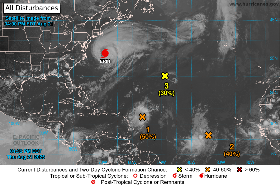
Watch: National Hurricane Center tracking three other areas of concern
02:30 , Oliver O'ConnellAugust 21, 2025 - Latest update on the tropics from the National Hurricane Center. For the latest information, please visit https://t.co/HwaVRhRCj3 pic.twitter.com/ohIbdmhOSm
— National Hurricane Center (@NWSNHC) August 21, 2025
Hurricane Erin: Where things stand on Thursday evening
02:00 , Oliver O'Connell- Hurricane Erin, a Category 2 storm, has battered North Carolina's Outer Banks with strong winds and waves, causing localized flooding and prompting the evacuation of over 2,000 people from Ocracoke Island.
- The hurricane is now moving north and out into the Atlantic, continuing to produce dangerous surf and rip currents along the East Coast, with warnings extending from the Carolinas to New England.
- Despite initial concerns, the Outer Banks largely avoided widespread destruction, with no significant structural damage reported to homes or businesses, though sections of Highway 12 were closed due to flooding and dunes were breached.
- Officials in New Jersey declared a state of emergency, and videos on social media show storm surge flooding in some streets near the ocean.
- Swimming bans were imposed on beaches from New York City to Bermuda due to life-threatening rip currents, with authorities urging residents to stay out of the water.
- Hurricane Erin, which formed on 11 August and rapidly intensified, is forecast to weaken and become a post-tropical storm over the weekend, with no predicted landfall in the U.S.
- Meteorologists are closely monitoring three other areas of concern in the Atlantic that could develop into tropical storm systems, with one having a high chance of becoming a tropical depression within seven days.
Watch: Waves crash into Wildwood, New Jersey
01:47 , Oliver O'ConnellAngry seas from Erin in North Wildwood. pic.twitter.com/t07JW3EYcz
— Michael Foley (@Michael29861415) August 22, 2025
Erin still a large hurricane — twice the size of the average storm
01:40 , Oliver O'ConnellHurricane Erin, formed nearly a week ago, remains an unusually large storm, spanning over 600 miles (965 kilometres) – double the size of an average hurricane – despite fluctuating intensity.
As of late Thursday morning, the hurricane centre reported Erin as a Category 2 storm, maintaining maximum sustained winds of 100 mph (160 kph). It is 285 miles (455 kilometres) east of Cape Hatteras.
The hurricane centre is also monitoring two tropical disturbances further out in the Atlantic. These 'Cape Verde' storms, developing over vast warm ocean waters, are historically among the most perilous to North America.
Watch: Flooding in downtown Margate, New Jersey
01:26 , Oliver O'ConnellA video posted to X by TV news journalist Jason Evans appears to show the streets of Margate, New Jersey, inundated with the storm surge from Hurricane Erin.
Serious flooding in Margate, NJ tonight as we deal with waves and storm surge from Hurricane Erin. pic.twitter.com/mTNGyo4vlx
— Jason Evans (@JasonDukeEvans) August 22, 2025
New threat of coastal erosion from Erin
01:00 , Oliver O'ConnellCoastal communities along North Carolina's Outer Banks faced an anxious Thursday morning as waves were estimated to reach heights of 5.5 meters (18 feet). The region, characterised by its low-lying sand dunes just a few feet above sea level, is particularly susceptible to the destructive power of storm surges, which can carve new inlets, wash vast amounts of sand and debris onto roads, and even damage infrastructure.
However, Dare County Manager Bobby Outten offered a measure of relief, stating that one of their gravest fears – the formation of new inlets – had not materialised with the storm Erin. Crucially, no significant structural damage was reported to homes or businesses.
“All in all, it's not as bad as it could have been,” Outten said. “Hopefully, the worst of it is behind us.”
The Hatteras Island Rescue Squad, a volunteer group, also confirmed they received no calls for rescues from Wednesday night through Thursday morning.
Despite the avoided catastrophe, the powerful waves did breach dunes on Hatteras and Ocracoke Islands, leading to the closure of sections of Highway 12, the area's primary thoroughfare. Ocracoke's vital connection to its ferry terminal was also severed.
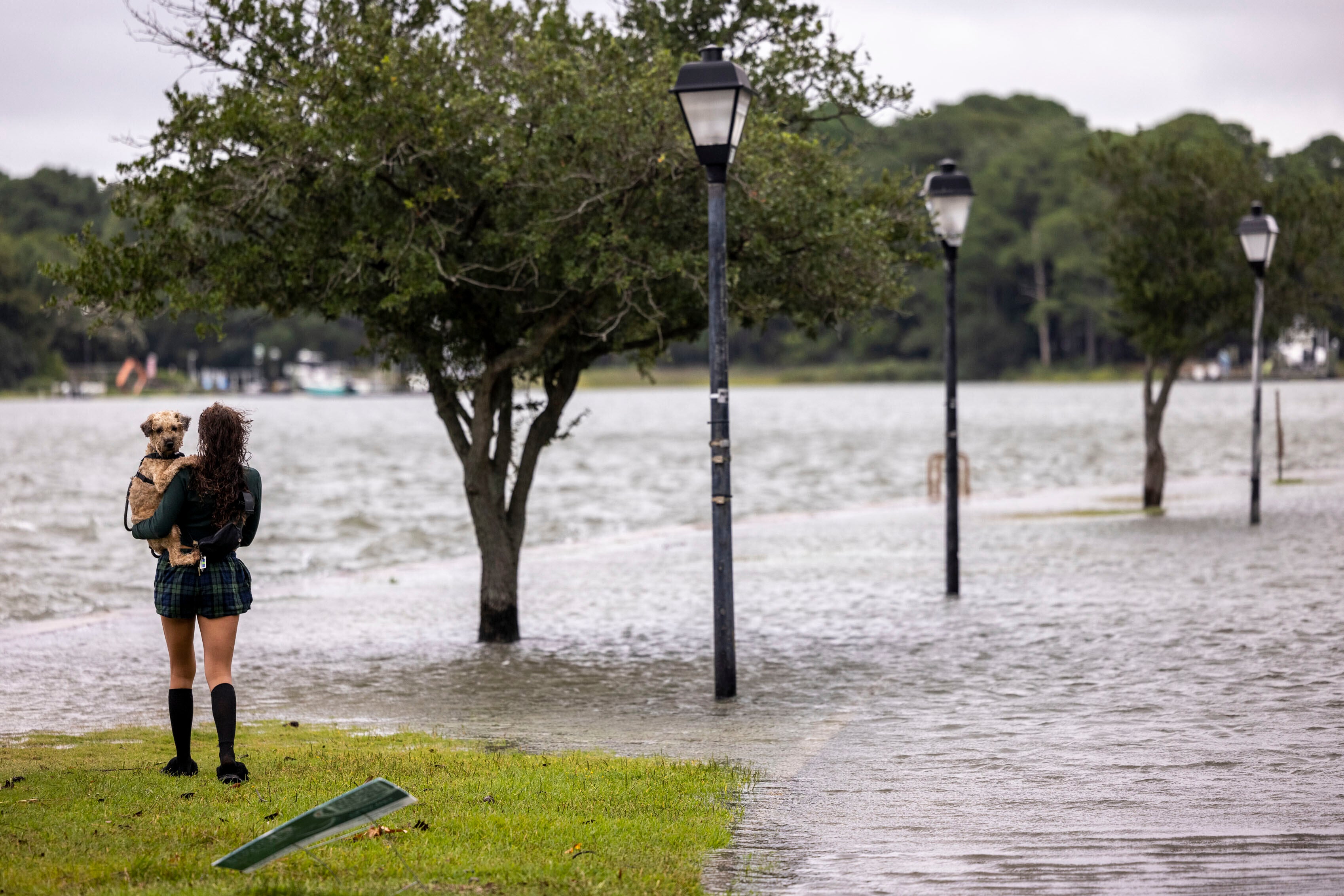
New York and New England feel Erin’s impact
Friday 22 August 2025 00:40 , Oliver O'ConnellCoastal communities along the mid-Atlantic and southern New England coast are bracing for tropical-storm-force wind gusts, with the National Hurricane Center in Miami warning these conditions could persist until early Friday.
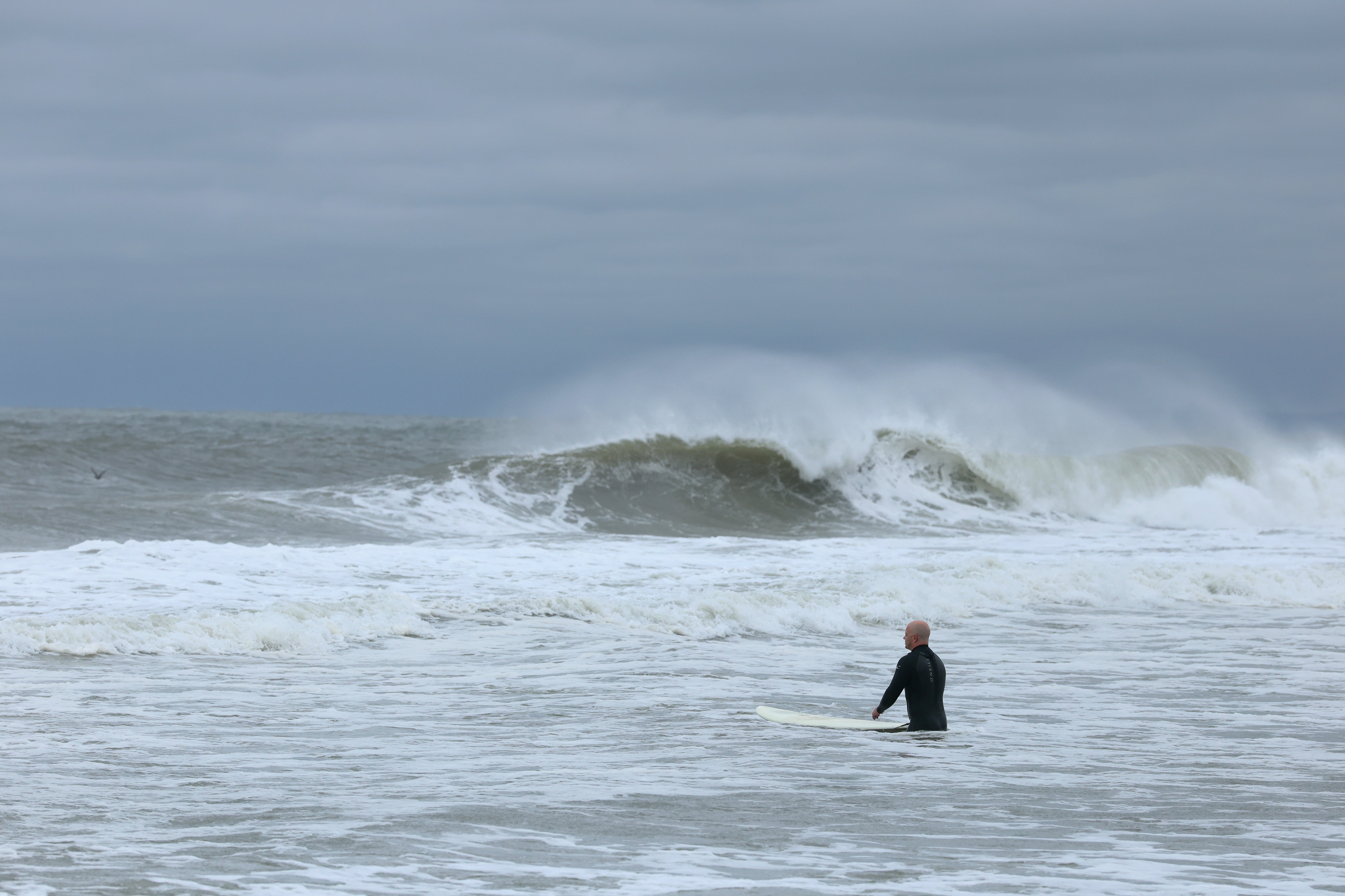
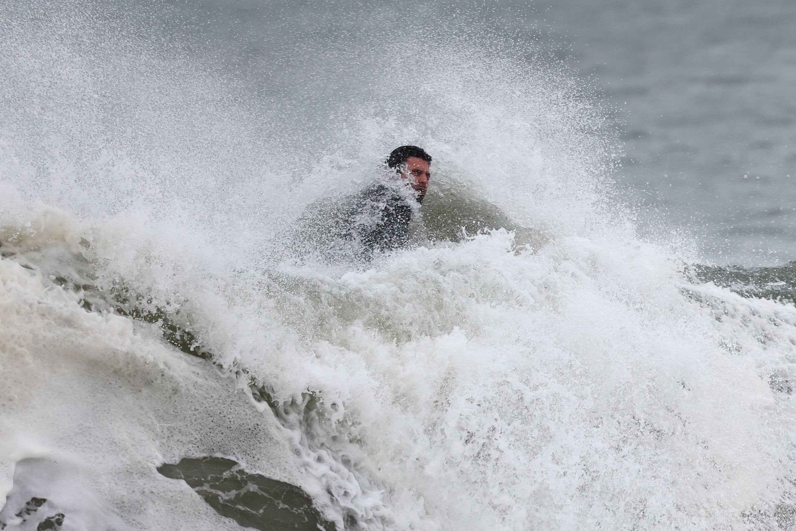
Despite swimming bans imposed on New York City beaches on Thursday, including Rockaway Beach in Queens, more than a dozen surfers were seen riding the waves.
Local resident Scott Klossner, who lives nearby, embraced the challenging conditions, saying: “You wait all year round for these kinds of waves. It’s challenging, really hard to stay in one place because there’s a heavy, heavy, heavy rip. But this is what surfers want — a hurricane that comes but doesn’t destroy my house? I’ll take that.”
Further north, Nantucket Island off the coast of Massachusetts is expected to see waves exceeding 10 feet (3 meters) this week. Authorities across the affected coastline have issued stark warnings throughout the week regarding potentially deadly rip currents. The danger was underscored earlier this week when dozens of people required rescue from Wrightsville Beach in North Carolina.
National Hurricane Center tracking three possible tropical depressions in Atlantic
Friday 22 August 2025 00:20 , Oliver O'ConnellMeteorologists are tracking three other potential tropical depressions in the Atlantic that could develop into storms over the next seven days, and then possibly even hurricanes.
“We're still following Hurricane Erin off the East Coast of the U.S., but we've got three other areas that we're watching,” a spokesperson for the National Hurricane Center in Miami said on Thursday afternoon.
“One of them far out in the Atlantic, another one in the middle of the Atlantic, and one approaching the Leeward Islands, a tropical wave that that is the system of most immediate concern to us, and we think it has a high chance of developing into a tropical depression within the next seven days, and a medium chance within two days, and it is a concern to the island of Bermuda by the weekend.”
Erin still stirring up dangerous waves, even as it heads out to sea
Friday 22 August 2025 00:00 , Oliver O'ConnellHurricane Erin has begun its slow departure from the US East Coast, generating significant waves along the mid-Atlantic coast after lashing North Carolina’s Outer Banks with strong winds and swells that caused localised flooding. Despite initial concerns, the low-lying barrier islands appear to have largely dodged widespread destruction during the storm’s first brush on Wednesday.
Even as Erin gradually weakens and moves further offshore, forecasters warn of continued dangerous rip currents and coastal flooding threats from the Carolinas to New England throughout the weekend. Damage assessments are still underway on the Outer Banks, with the potential for more flooding during Thursday evening’s high tide.
Tropical storm warnings remain active along the coasts of North Carolina and Virginia, and for the island of Bermuda. Authorities in Bermuda have advised residents and tourists to stay out of the water until Friday.
With reporting from AP
What was the impact on North Carolina's Outer Banks?
Thursday 21 August 2025 23:30 , Oliver O'ConnellIn the U.S., Hurricane Erin posed the most significant threat to North Carolina’s Outer Banks barrier islands, prompting Governor Josh Stein to declare a state of emergency on Tuesday.
The storm has brought dangerous waves and rip currents to the state, with sustained winds of 72 kph (45 mph) and gusts of 87 kph (54 mph) recorded at Jennette’s Pier in Nags Head. North Carolina has mobilized 200 National Guard troops and three swift-water rescue teams along the coast in preparation.
Highway 12, a crucial road for the Outer Banks, was closed on Wednesday night due to flooding from the storm surge.
Officials reported at least 75 people were rescued from rip currents in Wrightsville Beach, near Wilmington, by Tuesday.
In Rodanthe, two houses are perched precariously amid high waves; 11 other homes have collapsed into the surf there over the past five years as ocean waves erode the sand supporting their wooden pilings.
Here’s more on those houses:
Two more homes near collapse as Hurricane Erin waves pound North Carolina
NASA captures Hurricane Erin in 3D from space
Thursday 21 August 2025 23:00 , Oliver O'ConnellThis is both pretty cool and informative about the size of hurricanes.
We’re so used to seeing them top down on weather maps, but from the side, you really get a sense of the scale of these formations.
See Hurricane Erin in 3D 🌀
— NASA Earth (@NASAEarth) August 20, 2025
Erin went through a period of rapid intensification, strengthening from a Category 1 to a Category 5 hurricane in around 24 hours.@NASA’s GPM Core Observatory passed over Hurricane Erin at 6:23a.m. EDT on August 16th, while it was intensifying. pic.twitter.com/1cjErVekCy
Watch: National Hurricane Center tracking three other areas of concern
Thursday 21 August 2025 22:40 , Oliver O'ConnellAugust 21, 2025 - Latest update on the tropics from the National Hurricane Center. For the latest information, please visit https://t.co/HwaVRhRCj3 pic.twitter.com/ohIbdmhOSm
— National Hurricane Center (@NWSNHC) August 21, 2025
Dangerous conditions expected at beaches despite Erin moving on
Thursday 21 August 2025 22:20 , Oliver O'ConnellForecasters have warned that even though Hurricane Erin is set to move out into the open Atlantic, “dangerous conditions” may still prove hazardous for beach-goers over the weekend.
“Storm surge may impact beaches from the Delmarva coastline to southern New Jersey through late Thursday night,” according to Alex DaSilva, AccuWeather Lead Hurricane Expert.
“Several feet of water rise from Hurricane Erin may extend as far north as northern New Jersey and coastal areas near New York City.”
DaSilva added: “Even as Erin pushes out into the open Atlantic, dangerous conditions are expected at many beaches heading into the weekend.
“Do not let your guard down if you’re spending time at the beach on Friday or Saturday.
“It may seem like a nice beach day with sunshine and blue skies as the storm goes out to sea, but powerful rip currents will be lurking in the water through Saturday.”
What to know about Hurricane Erin as it tracks away from US
Thursday 21 August 2025 22:06 , Oliver O'ConnellHurricane Erin has continued to batter the North Carolina coast with powerful waves and gusty winds, even as it slowly tracks out to sea, posing an ongoing threat to beachgoers along the U.S. East Coast.
The storm, which had dropped to a Category 2 hurricane earlier in the week, maintained maximum sustained winds of around 100 mph (160 kph) on Thursday. The National Hurricane Centre in Miami forecast that Erin, currently 260 miles (420 kilometres) east of Cape Hatteras, North Carolina, and moving north-northeast at 18 mph (29 kph), could regain major hurricane status before weakening by Friday.
Despite assurances that Erin would not make direct landfall in the United States, authorities have warned of dangerous water conditions along the East Coast. This prompted evacuation orders on several islands within North Carolina’s Outer Banks, a popular tourist destination. By Wednesday evening, Highway 12 on Hatteras Island was closed due to rising storm surge, and Ocracoke Island’s ferry connection was severed.
Earlier in its trajectory, the hurricane brought heavy rainfall to parts of the southeast Bahamas and the Turks and Caicos Islands.
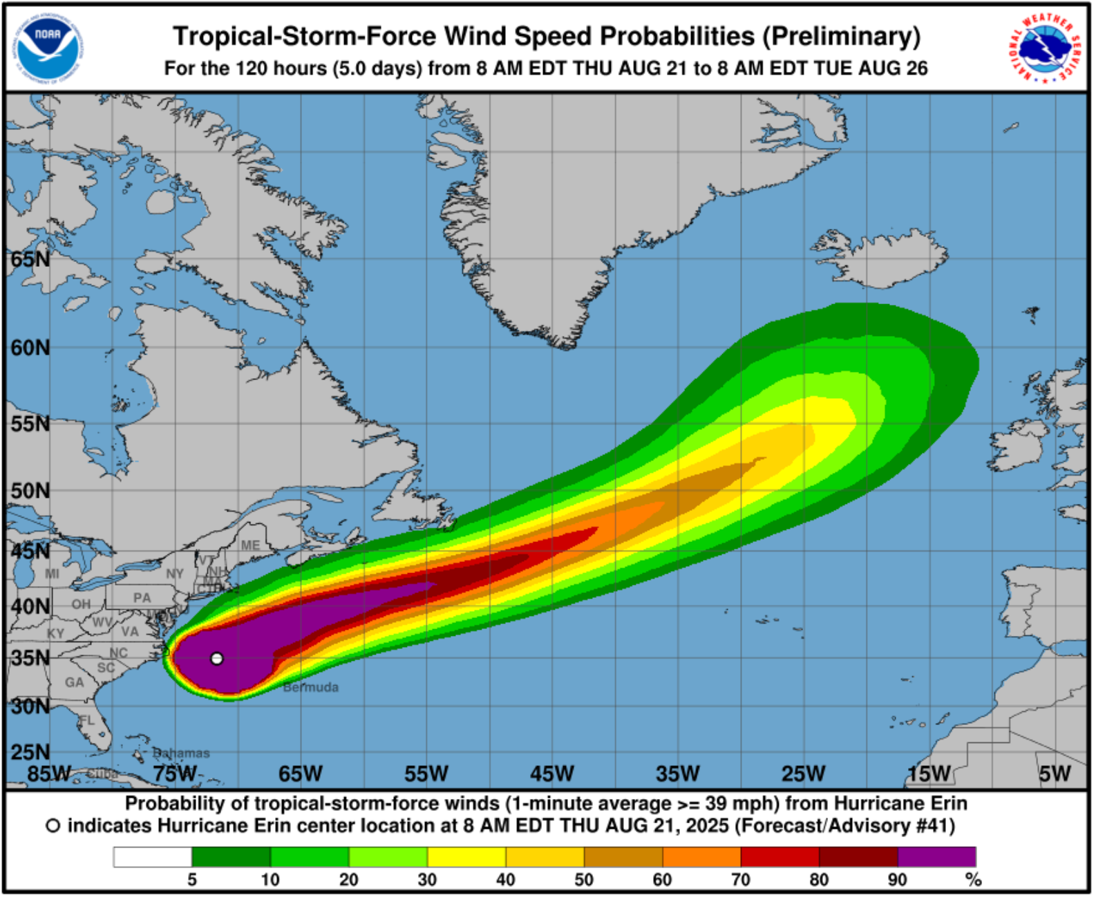
Hurricane Erin windspeeds to exceed 100 mph in parts Thursday
Thursday 21 August 2025 21:44 , Oliver O'ConnellTake a look at Thursday’s wind speed projections for Hurricane Erin, which predict that in parts near the coast, gusts may exceed 90 mph and approach triple digits.
NWS shares update on future potential storms
Thursday 21 August 2025 21:12 , Katie HawkinsonWhile National Weather Service forecasters are still watching Hurricane Erin, meteorologists are also monitoring three disturbances that could turn into stronger storms.
One of these disturbances has a “high chance” of developing into a tropical depression over the next seven days.
Watch the agency’s update below:
New Jersey issues state of emergency
Thursday 21 August 2025 20:56 , Katie HawkinsonNew Jersey is under a state of emergency due to Hurricane Erin.
“Over the past couple of days, we have seen the effects of Hurricane Erin along the Jersey Shore in the form of dangerous rip tides. Today and tomorrow will be no exception,” Murphy said in a statement.
“As the storm moves past New Jersey over the next 24 hours, we are expecting high surf and rip currents, coastal and flash flooding, and a high erosion risk in parts of the state,” he added. “We ask all New Jerseyans to monitor local weather forecasts and warnings and stay informed on evacuation protocols, especially if you’re down the Shore.”
Surfers still hit the waves despite swimming bans in NYC
Thursday 21 August 2025 20:48 , Katie HawkinsonNew York City officials have banned swimming at the city’s beaches until Friday due to rip currents caused by Hurricane Erin.
However, more than a dozen surfers were still in the water at Rockaway Beach in Queens on Thursday, the Associated Press reports.
"You wait all year round for these kinds of waves. It's challenging, really hard to stay in one place because there's a heavy, heavy, heavy rip," resident Scott Klossner told the AP. "But this is what surfers want — a hurricane that comes but doesn't destroy my house? I'll take that."
North Carolina governor issues warning to residents
Thursday 21 August 2025 20:40 , Katie HawkinsonNorth Carolina Governor Josh Stein issued a warning to residents today as Hurricane Erin batters the state’s Outer Banks.
“The storm continues to move away from the coast, but dangerous conditions - coastal flooding, high tide, and storm surge - are expected along the coast through the weekend,” Stein said just before 1 p.m. local time.
“Local states of emergency are still in effect in Currituck, Dare and Hyde counties. N.C. 12 remains closed on Hatteras Island and the northern part of Ocracoke Island,” he added. “The three Ocracoke vehicle ferry routes and the Ocracoke Express passenger ferry are still suspended and will resume once it's safe. Do not drive through flood waters.“
Tropical storm and surge warnings remain in Outer Banks
Thursday 21 August 2025 20:12 , Mike BediganTropical storm and surge warnings remain in the Outer Banks area of North Carolina, with the risk of property being flooded.
Wind gusts could still reach up to 50 mph and the surge could climb to four feet, according to the National Hurricane Center’s Thursday update.
Coastal flood alerts are in effect from both North and South up to coastal Connecticut.
National Hurricane Center update
Thursday 21 August 2025 20:00 , Mike BediganHurricane #Erin Advisory 41A: Tropical Storm Warning Issued For Bermuda. Beachgoers Are Cautioned Against Swimming At Most U. S. East Coast Beaches Due to Life-Threatening Surf and Rip Currents. https://t.co/tW4KeGdBFb
— National Hurricane Center (@NHC_Atlantic) August 21, 2025
'Absolutely no one should be in the water' says New Jersey Governor
Thursday 21 August 2025 19:47 , Mike BediganLife-threatening rip currents will be present at all ocean beaches across the state. Absolutely no one should be in the water today or tomorrow.
— Governor Phil Murphy (@GovMurphy) August 21, 2025
Dangerous surf and rip currents are expected over the next several days. Stay safe, New Jersey.
Erin to near UK and Europe by early next week
Thursday 21 August 2025 19:35 , Mike Bedigan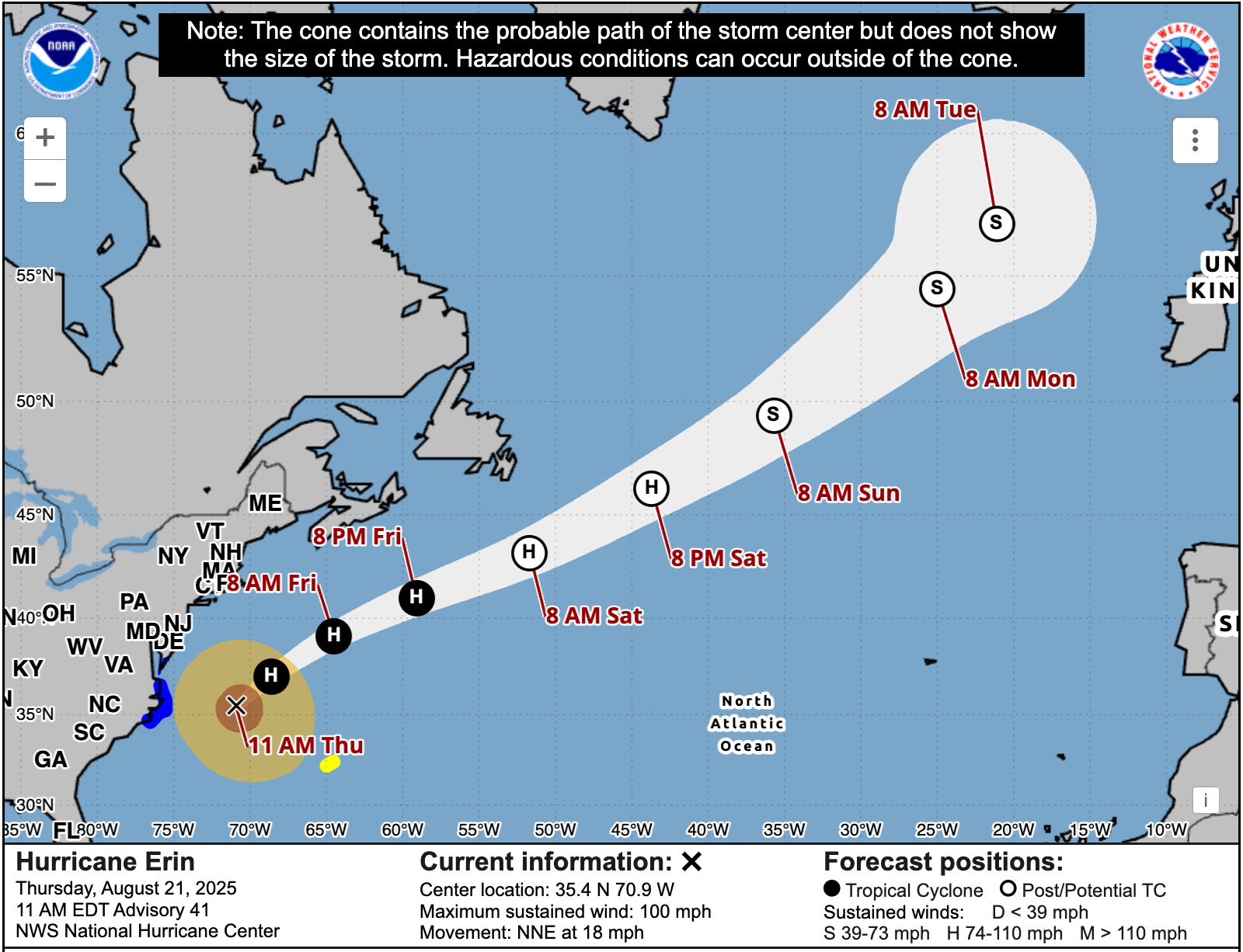
Erin expected to become 'post-tropical' storm by the weekend
Thursday 21 August 2025 19:18 , Mike BediganAccording to the National Hurricane Center, a “gradual weakening is forecast during the next couple of days,” for Hurricane Erin.
“Erin is expected to become post-tropical on Saturday,” the forecaster said.
Weather Service warns of hidden dangers
Thursday 21 August 2025 19:03 , Mike BediganEven with today's beautiful-looking beach weather for much of the coast from South Carolina to Florida, Erin is creating some potential dangers beneath the waves.
— National Weather Service (@NWS) August 21, 2025
It looks safe…until it’s not. Strong rip currents can pull you out in seconds. Follow advice from lifeguards, local… pic.twitter.com/Fpw4rWP8th
Watch: The local impacts of Hurricane Erin
Thursday 21 August 2025 18:50 , Mike BediganThreats still remain as Erin moves away from U.S. coast
Thursday 21 August 2025 18:35 , Mike BediganThough Hurricane Erin is now heading back out across the Atlantic, threats still remain.
According to the National Hurricane Center, wind gusts to tropical storm force will continue to be likely along portions of the remainder of the U.S. Mid-Atlantic and southern New England coasts until early Friday.
Tropical storm conditions are also possible on Bermuda this afternoon through early Friday.
In addition, there is potential for gale force winds along the coast of Nova Scotia on Friday and the Avalon Peninsula of Newfoundland on Saturday.
In pictures: New Jersey surfers brave waters despite warnings
Thursday 21 August 2025 18:23 , Mike Bedigan
Watch: National Hurricane Center gives Thursday update
Thursday 21 August 2025 18:10 , Mike BediganAUG 21 - AM: Dr. Michael Brennan provides a LIVE update on Hurricane #Erin from the National Hurricane Center: https://t.co/ofIk6HXEnu
— National Hurricane Center (@NWSNHC) August 21, 2025
For the latest forecasts, visit: https://t.co/TeBEKbX7SB pic.twitter.com/meGavpHvez
Erin is still a 'sprawling' hurricane
Thursday 21 August 2025 17:42 , Mike BediganDespite no longer being a Category 3 storm, Hurricane Erin “remains a sprawling hurricane,” per the National Hurricane Center’s 11 a.m. briefing.
Erin’s tropical-storm-force winds, the measurement for how far-reaching a storm is, extend nearly 500 nautical miles across.
When compared with weather systems around the same intensity and in similar locations over the past couple of decades, Erin registers within the 90th percentile in size.
As of the latest update, Erin’s winds are sustained at around 100 mph in certain areas.
NASA captures Hurricane Erin in 3D from space
Thursday 21 August 2025 17:32 , Mike BediganThis is pretty cool.
See Hurricane Erin in 3D 🌀
— NASA Earth (@NASAEarth) August 20, 2025
Erin went through a period of rapid intensification, strengthening from a Category 1 to a Category 5 hurricane in around 24 hours.@NASA’s GPM Core Observatory passed over Hurricane Erin at 6:23a.m. EDT on August 16th, while it was intensifying. pic.twitter.com/1cjErVekCy
Watch: Storm surge, strong winds hit MD, VA & DE
Thursday 21 August 2025 17:23 , Mike BediganCoastal flooding warnings in affect for NYC
Thursday 21 August 2025 17:03 , Mike BediganCoastal flood warnings were put in place Thursday for the Jersey Shore and New York City's south-facing beaches.
Most beaches were previously closed to swimming for the next few dats, with officials urging people to stay out of the water.
Authorities noted that the risk of flooding increases Thursday into Friday, when high waves coincide with high tide.
Hurricane Erin windspeeds to exceed 100 mph in parts Thursday
Thursday 21 August 2025 16:47 , Mike BediganTake a look at Thursday’s windspeed projections for Hurricane Erin, which predict that in parts near to the coast, gust may exceed 90 mph and approach triple digits.
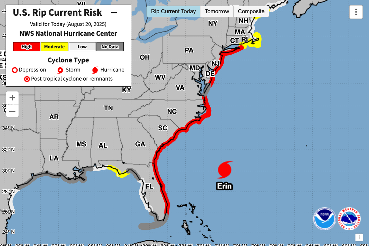
What is a rip current?
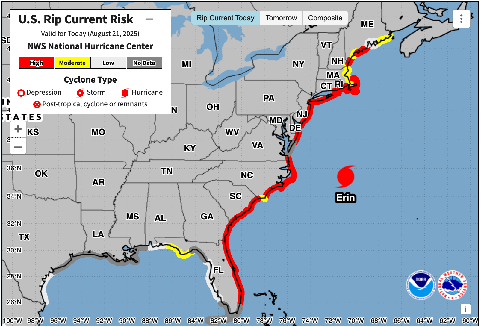
Thursday 21 August 2025 16:37 , Mike BediganThe National Hurricane Center has warned that there is a high risk of rip currents along the majority of the East Coast on Thursday.
But what are they?
According to NOAA, rip currents are powerful, narrow channels of fast-moving water that are prevalent along the East, Gulf, and West coasts of the U.S., as well as along the shores of the Great Lakes.
Rip currents can move at speeds of up to eight feet per second, which is faster than an Olympic swimmer.
Swimmers who panic, often try to counter a rip current by swimming straight back to shore, though this can put them at risk of drowning due to fatigue.
Per NOAA, lifeguards rescue tens of thousands of people from rip currents in the U.S. every year, but it is estimated that 100 people are killed by rip currents annually.
Rip currents are often confused with rip tides.
A rip tide is a specific type of current associated with the swift movement of tidal water through inlets and the mouths of estuaries, embayments, and harbors.
High risk of rip currents along majority of East Coast
Thursday 21 August 2025 16:25 , Mike BediganA Thursday map projection from the National Hurricane Center shows a high risk of rip currents along the majority of the U.S. east coast.