The story so far: On December 5, Cyclone Michaung (pronounced mig-jaum) made landfall over Nellore in Andhra Pradesh as a super-cyclonic storm. A day earlier, the weather system had produced 150-200 mm of rain in north Tamil Nadu.
How did the cyclonic storm take shape?
On November 29, the India Meteorological Department (IMD) identified a well-marked low pressure area in the southwest Bay of Bengal. It was expected to become a depression by November 30, a deep depression on December 2, and eventually a cyclonic storm by December 3. Thereafter, the IMD forecast that the system would move north towards coastal Andhra Pradesh, bringing rain and strong winds to areas in north Tamil Nadu on December 3 and 4, while travelling parallel to the latter’s coast. It was finally expected to cross over land between Nellore and Machilipatnam as a cyclonic storm, with 80-90 km/hr winds gusting to 100 km/hr.

On December 1, the Joint Typhoon Warning Centre (JTWC), a joint U.S. Air Force and Navy command, upgraded the likelihood of cyclone formation to ‘high’. By December 2, the depression had intensified into a deep depression, as expected, while it was around 500 km southeast of Chennai and moving at around 17 km/hr. It was expected to approach Chennai within two days even though, soon after, the system also seemed to slow its northward progress. By the end of the day, it had come to within 400 km of Chennai, still as a deep depression, and induced rain over the city’s south.
At this time, the JTWC data indicated that the sea surface temperature was around 28 degrees C. More than 27 degrees C is favourable for cyclogenesis, the process by which cyclones are created and intensify.
By the morning of December 3, the system had become cyclonic.
Why was Michaung named so?
In 2000, a panel of the World Meteorological Organisation together with members of the United Nations Economic and Social Commission prepared the list of names of tropical cyclones in the Bay of Bengal and the Arabian Sea, to be given from the September 2004 season. The name of each cyclone is picked from this list and cycles through each country’s suggestion.
For example, after Michaung (by Myanmar), the next five cyclones will be called ‘Remal’ (Oman), ‘Asna’ (Pakistan), ‘Dana’ (Qatar), ‘Fengal’ (Saudi Arabia), and ‘Shakhti’ (Sri Lanka).
How did Cyclone Michaung proceed?
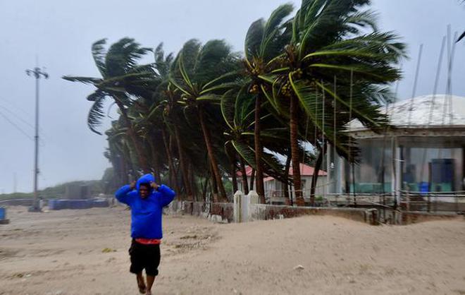
As Cyclone Michaung approached north Tamil Nadu, Chennai and the surrounding districts of Kancheepuram, Thiruvallur, and Chengalpattu began to receive rain. The State government declared a public holiday in these areas on December 4, later extended to December 5, after the IMD forecast heavy showers.
By the evening of December 3, Cyclone Michaung was 200 km from the city, roughly east, and had slowed to around 8 km/hr. By December 4 morning, and contrary to expectations, it had moved more westward than northward, bringing it within 150 km of the city, dumping a large quantity of water as rain together with strong winds gusting up to 80 km/hr.

Cyclone Michaung continued to remain close to Chennai on December 4 evening, with many areas in the city reporting receiving more than 120 mm of rain in the previous 24 hours, and some more than 250 mm. There were several reports of localised flooding and people stranded in places where the water refused to drain, together with a city-wide power cut.
Nonetheless, Chennai managed to fare better than it did after the 2015 rains thanks to controlled release of water from the Chembarambakkam reservoir. Eight years ago, an uncontrolled release of a large volume had flooded the city.
Rains in Chennai finally ceased in the wee hours of December 5 as Cyclone Michaung resumed its northward journey.
Why did Cyclone Michaung intensify?
On December 4, the cyclonic storm intensified into a super-cyclonic storm. Such intensification events are a source of uncertainty in cyclone models because they alter the storm’s future course.
Tropical cyclones are ‘engines’ that use a warm sea surface as ‘fuel’. This is why they form close to the equator (but seldom at the equator itself because the spinning force, called the Coriolis force, is lowest there).
As air moves over such a warm sea, it also becomes warmer and laden with moisture, and begins to ascend. In the process, it becomes cooler, which condenses the vapour and forms clouds. Condensation releases heat, which makes the air lighter and causes it to ascend further. As it does, the surrounding air moves in underneath, creating the surface winds associated with cyclones.
This (simplified) process is the reason climate change – and the resulting sea-surface warming, since these large water bodies absorb the vast majority of the heat of global warming – has been conducive to cyclone intensification.

The intensification is also greater if the cyclone spends more time over the water before landfall, as Cyclone Michaung did off the coast of north Tamil Nadu.
Why does intensification matter?
Cyclones draw heat from the sea and move it to the upper atmosphere, where winds carry it to the earth’s poles and warm them. An intensifying cyclone will do this more powerfully.
A study published in May 2020 found that tropical cyclones with wind speeds upwards of 185 km/hr had become 15% more likely since 1979.
In 2021, Cyclone Yaas took advantage of an Arabian Sea surface temperature of 32 degrees C for several days before slamming into Gujarat as an extremely severe cyclonic storm. Roxy Mathew Koll, scientist at the Indian Institute of Tropical Meteorology, Pune, had said at the time that “rising ocean temperatures in both [the Arabian Sea and the Bay of Bengal] are assisting … cyclones in their ‘rapid intensification’ process. Otherwise, we don’t see a significant increase in the number of cyclones over the Bay of Bengal as we see in the Arabian Sea.”
Cyclone Michaung’s own intensification was also assisted by the Madden-Julian oscillation (MJO), among other factors, according to a December 3 advisory from the Regional Specialised Meteorological Centre – Tropical Cyclones, New Delhi.
The MJO consists of a ‘pair’ of weather anomalies that move eastward around the world once every one to two months. The leading side imposes dry weather while the trailing side imposes wet (rainy) weather. The advisory said that on December 3, the MJO was in phase 4, near Cyclone Michaung, indicating favourable conditions for rain formation.
Aside from complicating forecast models, cyclone intensification allows these storms to make landfall with more energy, move further inland, survive longer, and extend their on-ground devastation to previously ‘inaccessible’ areas.
What was Cyclone Michaung’s fate?
According to local reports, Cyclone Michaung crossed over land just south of Bapatla district in Andhra Pradesh from 12.30 pm on December 5 as a super-cyclonic storm. It brought heavy rain and winds with a sustained speed of 90-100 km/hr as it crossed over over a period of three or so hours, in the process uprooting trees and electric poles.
As of 9 am on December 6, its effects on the ground — often as a result of poor infrastructure — had led to the deaths of 12 people.
Based on radar data up to 3.30 pm on December 5, the IMD reported that the storm had completed landfall and “lay centred … over south coastal Andhra Pradesh, about 20 km west-southwest of Bapatla and 45 km north-northeast of Ongole”.
An hour later, an IMD bulletin said the storm system was moving northward at 11 km/hr while weakening into a cyclonic storm over the next couple hours. This is a direct result of the cyclonic ‘engine’ losing its source of ‘fuel’ — a warm water-body underneath. The State’s north coast was forecast to experience rain with winds of 50-60 km/hr in this time.
By 6 pm on December 6, the IMD had expected the storm to devolve into a well-marked low pressure area.
- On December 5, Cyclone Michaung (pronounced mig-jaum) made landfall over Nellore in Andhra Pradesh as a super-cyclonic storm. A day earlier, the weather system had produced 150-200 mm of rain in north Tamil Nadu.
- On December 1, the Joint Typhoon Warning Centre (JTWC), a joint U.S. Air Force and Navy command, upgraded the likelihood of cyclone formation to ‘high’. By December 2, the depression had intensified into a deep depression, as expected, while it was around 500 km southeast of Chennai and moving at around 17 km/hr.
- Based on radar data up to 3.30 pm on December 5, the IMD reported that the storm had completed landfall and “lay centred … over south coastal Andhra Pradesh, about 20 km west-southwest of Bapatla and 45 km north-northeast of Ongole”.