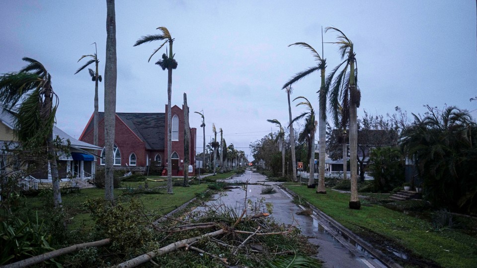
Hurricane Ian is one of the most destructive hurricanes ever to hit Florida. A day after the storm made landfall, hundreds of people have been rescued and, as of this morning, millions were without power. President Joe Biden has indicated that early reports suggest “substantial loss of life,” but no firm numbers have been confirmed. With such a catastrophic storm coming after the string of disasters this summer, some commentators have tried to link Hurricane Ian to climate change.
But while climate change is clearly fueling some disasters, such as heat waves and wildfires, it has a more complicated effect on hurricanes. The most recent report from the Intergovernmental Panel on Climate Change, the United Nations–led panel of hundreds of climate scientists from around the world, has said that it’s an “established fact” that industrial carbon pollution has led to an increase in “frequency” or “intensity” of extreme weather. But the report uses more circumspect language such as “likely” to talk about tropical cyclones. (Tropical cyclones are only called hurricanes when they’re above a certain wind speed and in the Atlantic or North Pacific Ocean.)
Climate change is changing hurricanes in a few ways. “First of all, you can have more intense hurricanes in a warmer climate. That finding goes back well over 30 years now,” Kerry Emanuel, an MIT meteorologist and an expert on how climate change affects hurricanes, told me. “For that reason we expect to see more of the highest-category storms—the Cat 3s, Cat 4s, Cat 5s, more of the Ian-style storms.”
[Read: How Hurricane Irma is sucking Florida’s beaches dry]
In effect, climate change raises the speed limit on storms, he said, allowing hurricanes to attain a higher wind speed than they would otherwise. Why does this happen? It arises from the brute-force physics of a hurricane colliding with the inescapable presence of greenhouse gases. “A hurricane is a heat engine,” Emanuel told me, turning heat from the ocean into wind energy. This transformation happens because as water evaporates from the sea surface, it transfers heat from the ocean to the atmosphere, essentially speeding the storm. (The underlying phenomenon here is also why “if you’re wet, you feel cold, all else being equal,” Emanuel said.)
So how does the ocean get hot in the first place? There is really only one way for heat to enter the ocean and only two ways for it to leave, he said. Heat always arrives in the ocean as sunlight; it always leaves as infrared radiation, which is emitted back into space, or as evaporation from the sea surface. But carbon dioxide and other climate pollutants prevent infrared radiation from escaping the ocean—that’s the “greenhouse effect” that gives greenhouse gases their name. Because heat has nowhere else to go, the rate of sea-surface evaporation has to speed up, which means more heat energy can pass into the storm.
In other words, climate change “creates the conditions for water to evaporate faster,” Emanuel said, which means more heat can enter a given storm—and it can get windier.
Second, researchers agree that hurricanes can now strengthen far faster than they could in the old climate. The number of tropical cyclones that have undergone “rapid intensification”—a term of art meaning a storm’s top wind speed has increased by at least 35 miles per hour over a 24-hour period—has “likely” risen over the past 40 years, the IPCC has found.
“The forecaster’s nightmare is going to bed with a tropical storm in the Gulf of Mexico and waking up to a Cat 4 bearing down on a city” that has no time to evacuate, he told me. Even when meteorologists can safely predict that a storm will rapidly intensify, they can struggle to communicate its risks to the public.
Hurricane Ian looks like a textbook case of rapid intensification: On Monday morning, its top wind speeds were 75 miles per hour, barely qualifying the storm as a hurricane; just 48 hours later, its winds howled at up to 155 miles per hour—just shy of Category 5 status—as it made landfall in Cayo Costa, Florida. Indeed, people may feel like every hurricane to hit the United States recently has undergone a similar metamorphosis. Last year, Hurricane Ida made landfall in Louisiana as a powerful Category 4 storm only 74 hours after it became a tropical depression; the storm formed and came ashore faster than New Orleans could evacuate. In 2018, Hurricane Michael rapidly exploded into Category 4 status before it walloped the Florida Panhandle; a year earlier, Hurricanes Harvey and Irma also experienced rapid intensification before they made landfall.
Finally, climate change is making hurricanes rainier, Emanuel said. That’s actually true of most storms, tropical or not, but it’s especially important for hurricanes, because rain from a given hurricane can combine with other impacts to increase a storm’s overall danger.
[Read: Did climate change intensify Hurricane Harvey?]
“If you have a more intense storm and an elevated sea level, you’re going to be more susceptible to surge flooding,” when the storm pushes the ocean ashore, he told me. Then, surge flooding and “freshwater flooding” from all that extra rain “can gang up,” he said, creating a brackish flooding disaster. “It looks like that’s what happened in Fort Myers,” which has seen some of the worst damage, he told me.
So that’s what scientists do know about climate change and hurricanes. But much remains unclear or unknown about how the two interact. There’s essentially no agreement on what a warming climate will do to smaller hurricanes in the Category 1 or 2 range, Emanuel said. Historically, these less intense storms form far more often than major storms, and they dominate the raw numbers of hurricanes that form each year (although major hurricanes still cause by far the most damage). But “we just don’t know if the number of those smaller storms will be more or fewer or stay the same.”
Climatologists also don’t know what will happen to the diameter of hurricanes. The size of hurricanes is an overlooked but important aspect of a storm’s danger, Emanuel said. For instance, Hurricane Ian made landfall in almost the same place that Hurricane Charley did in 2004, but Ian is a much wider—and thus a much more destructive—storm. Charley, in fact, could almost fit entirely within Ian’s eye. Idealized computer models show that climate change will likely make these monster storms more common, Emanuel said, but so far “nobody wants to carry that over to the real world,” which is far more complex than a simulation.
So what can we say about climate change’s effect on Ian? Stepping back, it seems safe to say that it showed some symptoms of climate change. It rapidly intensified. It dumped huge amounts of rain. You could even argue that it showed evidence of that “higher speed limit.” But asking questions beyond that is folly, Emanuel said.
“I don’t like the question ‘How did climate change affect this storm?’” he told me. “If you had a grandparent who died of lung cancer and who smoked two packs a day, you wouldn’t ask, ‘How much did smoking contribute to his lung cancer?’ Because sometimes people get lung cancer without smoking at all. You just can’t answer that question.”