Two of the Bureau of Meteorology’s highest-resolution forecasting models showed the dangerous storm that flooded Lismore this week returning to the area, at the same time as relieved residents were heading home after an evacuation order was lifted.
When the acting New South Wales premier, Paul Toole, addressed media on Wednesday, after Lismore’s CBD was evacuated for the second time in 24 hours, he said “no one could have predicted some of the amounts of rainfall that we have seen land”.
But two of the BoM’s most sophisticated simulation models showed the storm front, which some forecasts predicted would head out to sea, instead returning inland.
Weather forecasting is an inexact science and all meteorologists rely on multiple models as part of their work, but multiple independent sources have questioned why Lismore CBD residents were being told it was safe to be at home on Tuesday evening.
At 5.35pm on Tuesday, based on BoM advice, the State Emergency Service issued an “all clear”, cancelling a previously issued evacuation order for areas including the Lismore CBD and Lismore basin and telling residents they could “return safely with caution”.
But shortly before 1am on Wednesday, after heavy rain, the BoM’s advice for Lismore was again upgraded to a major flood warning, and an evacuation alert was reinstated by the SES at 3am.
Mark Hardy, a meteorologist and the founder of Weatherzone, said that modelling early on Tuesday evening suggested the northern rivers region of NSW was likely not yet out of the woods.
“A few of the models were having the low [pressure system] spinning away off to the coast and down to the south,” Hardy said. But two high-resolution BoM models that cover northern NSW – the Brisbane and Sydney Access-C models – “were both indicating the low was going to suck back towards the coast and intensify rapidly”, he said.
“When they saw that model that afternoon … that should have been alarming.”

Weatherzone is a private company that pays for access to the same forecasting models as the BoM.
At any given point a meteorologist may be consulting “half a dozen different weather models, running all at different times at different resolutions”, Hardy said.
But the Access-C models were of very high resolution and were the BoM’s “fastest-running models”, he added.
Thomas Hinterdorfer, an extreme weather chaser who works for Higgins Storm Chasing, confirmed that the Access-C modelling on Tuesday showed heavy rain was expected to fall across parts of the northern rivers overnight.
“Model data was indicating between 200 and 400mm in the 12 hours … from 7pm,” Hinterdorfer said.
“It was a very concerning forecast to be looking at.”

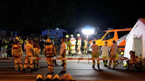
Flood waters ultimately peaked in Lismore at 11.4 metres, well above the levee height of 10.6 metres, and the city’s fifth highest flood on record.
A spokesperson for the NSW SES said the first evacuation order on Tuesday was cancelled when the “the river level did not reach the forecast heights and began to fall, meaning that risk was no longer present”.
“There was exceptional new rainfall that subsequently fell that night that was not forecast. This resulted in flash flooding and the Wilsons River to rise once again. There was a need to reissue the evacuation warning and subsequent evacuation order to warn the community.”
The Lismore state Labor MP, Janelle Saffin, whose property was flooded four weeks ago, said: “We got told, ‘Evacuation off, safe to return’.”
“The key issue is it was wrong. We just didn’t get timely warnings.
“The modelling [indicating heavy rain] – I know it was there. Someone alerted me to it,” she said. “That was why I then raised it at the highest level.”
In a statement, the BoM declined to answer questions about specific advice provided on Tuesday, saying it had forecast the risk of heavy rainfall for northern NSW “many days in advance, with flood watches and warnings also issued days in advance”.
“Severe weather warnings have been in place since Saturday for northern NSW, including for Byron Bay and Lismore, including the potential for life threatening and dangerous flash flooding,” it said.
The incoming member of the NSW upper house for the Greens, and Lismore resident, Sue Higginson, said climate change meant risk calculations needed to be altered in emergency situations.
On Tuesday night, “the inability of the state to respond appropriately, reasonably and safely were exposed”, Higginson said.
“We need to understand that our systems are not able, right now in their current form, to safely navigate what we’re facing. And that’s the first stage of response. We need to acknowledge that the state is failing in its capacities to keep its community safe.”
At Wednesday’s press conference, the BoM meteorologist Dean Narramore said it was getting harder to predict flooding events and that work was being done to improve modelling.
“We’re moving into high-resolution modelling, that is a much finer scale so it can pick up these convective elements,” he said.
Most independent and government weather organisations rely on publicly available models coordinated by the World Meteorological Organization, a UN agency.
“The government weather models are pretty much best of breed around the world these days,” Hardy said. “It’s the way you use them, of course, that’s quite critical.”