Ex-Cyclone Lincoln is drifting towards Western Australia but heavy rain could linger a little longer over north western Queensland and the Northern Territory as NSW prepares for a soaking.
The NSW central and southern tablelands could be hit with severe thunderstorms on Sunday afternoon from a humid and unstable air mass along the Great Dividing Range, the Bureau of Meteorology warned.
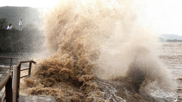
Locally intense rainfall was forecast across central eastern NSW with a warning area stretching from Coonabarabran south to Canberra with the possibility of large hailstones and flash flooding.
Almost 30mm of rain fell in as many minutes at Orange Airport shortly after noon.
Parts of the Illawarra and Hunter regions may also be affected, with the bureau monitoring whether Sydney, Wollongong or Newcastle could also be impacted on Sunday afternoon.
It comes ahead of a wet week with daily showers and thunderstorms forecast across the east of the state bringing the possibility of heavy rain and flash flooding.
In the north, ex-cyclone Lincoln is tracking from the Gulf of Carpentaria across central NT and will continue to deliver strong winds and heavy rain to already-soaked areas of the Top End.
Lincoln could redevelop into a cyclone off the northwest coast of Western Australia midway through the week, the bureau said on Sunday.
It warned of heavy, locally intense rainfall and damaging wind gusts extending west throughout the day.
Tennant Creek received more than 138mm of rainfall in the 24 hours to 9am on Sunday, the bureau said.
Intense rain could lead to flash flooding in the southern Gregory and northern Tanami districts in the territory's west, with up to 180mm to fall in some parts.
Damaging winds could reach 90km/h.
The tropical low is expected to reach the Kimberley by Monday.
Major flood warnings remain for western Queensland on the Diamantina, Nicholson and Flinders rivers.
Showers and thunderstorms, although not severe, were expected across the state's far north, northwest and near the NSW border in the southern interior on Sunday.
Emergency Management Minister Murray Watt urged people to stay across warnings from the bureau.
"We are seeing some pretty serious weather conditions around a number of parts of the country at the moment," he said on Sunday.