It’s become an unfortunate norm among automakers to promise new features first and then deliver them weeks or months later via software updates. And the execution is often lousy and imperfect.
But Google’s software prowess and the established Android Automotive OS ecosystem mean the upcoming 2026 Polestar 4 might skip the sluggishness of these over-the-air software updates—and vastly improve navigation.
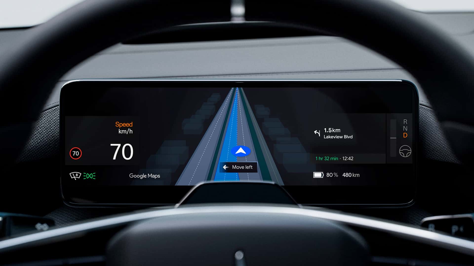
The electric coupe-shaped crossover will debut Google’s new Live Lane Guidance system for the first time in any vehicle. I drove the Polestar 4 in Austin, Texas, last week, but the feature wasn’t yet active on our test cars. But Polestar today announced more about the feature, and it's quite intriguing.

"The feature detects which lane the car is in by using Google’s advanced AI in the vehicle to analyze elements on the road, like lane markings and road signs, captured by one of the forward-facing cameras in Polestar 4," Polestar officials said.
In theory, it sounds genuinely useful. The system will generate a live visualization on the 10.2-inch instrument cluster, helping drivers stay in the correct lane when road layouts get complicated. If you’re wandering off the route, the system will send audio and visual alerts to return to the correct lane.
Typically, Google Maps relies on a top-down GPS view, supported by an internet connection for location accuracy and live traffic data. Live Lane Guidance adds a new layer to that, mixing camera input with AI to nudge the driver left or right if they’ve wandered into the wrong lane.
It may seem like a small addition, but it can save you from missing an important exit or on-ramp.
It can also be useful where GPS signals are often inaccurate, such as in Manhattan. Every time I drive there, GPS accuracy falters as skyscrapers block satellite signals.
In New York City, at least, Google Maps also cannot tell whether I am on the flyover or the service road directly underneath. It could also be helpful on sprawling Texas highways, where a dozen lanes run parallel, and Maps can be just as confusing. By fusing camera vision and AI with GPS, the vehicle should better recognize complex road conditions.
And if the system works as promised, it will likely push drivers to rely more on the vehicle's native navigation than on using Apple CarPlay, which is overwhelmingly popular among owners for its simplicity and better navigation.
It will initially be available on select highways in Sweden and the U.S., before expanding to other markets and possibly other models, too. Still, for now it’s just a promise. We’ll see how it works when Polestar rolls it out “in the next couple of months.”
Have a tip? Contact the author: suvrat.kothari@insideevs.com