We’re going to wind up the live blog. Thanks for following along today. You can read our full story about Hurricane Michael here.
If you want to make sure you never miss out on the news of the day, sign up the Guardian’s new US morning briefing and we’ll bring you up to speed on the day’s top stories and must-reads every weekday morning.
What we know so far
- Hurricane Michael, the strongest storm to ever hit the Florida Panhandle, was upgraded to a category 4 hurricane in the early hours of Wednesday morning as it approached the coast of Florida.
- It made landfall on Wednesday at about lunchtime, near Mexico Beach, Florida with winds of 155 mph.
- One death has been reported, of a Florida man killed by a falling tree in Gadsden County. A woman was hit in the head by a falling tree limb and her condition is not clear
- It is the strongest storm to hit the continental US is more than 25 years, and the third most intense hurricane to ever make landfall on the continental US.
- Trump has described the storm as a “monster” and acknowledged the poverty in the area hampered evacuation efforts, with thousands of residents staying in their homes.
- More than 311,000 homes and businesses in Florida, Georgia and Alabama are without power due to the hurricane.
- Hurricane Michael was downgraded to a category 1 storm on Wednesday night with maximum wind speeds of 90 mph.
Jamiles Lartey is in Marianna, Florida, which was hit by the hurricane earlier today. He has this dispatch from one of the shelters where people are riding out the storm.
The primary shelter for Jackson County is at the Marianna high school where some 550 had filed in the lead-up to the storm.
Many, like Teangelia Sims came as early as 5am Tuesday morning.
“We’ve never had a category 4 and I’ve seen what [weaker storms] have done in previous years so I wasn’t going to take that risk,” Sims said.
She came here with her two children but was preparing to go to work just after the intense winds of the eye wall passed over.
“We have to be there, we can’t not show up. Don’t really have a choice,” said Sims, who is a sergeant at the Jackson county prison in Malone, Florida.
Administrators told her to prepare to be at the prison for up to 24 hours.
The shelter is bustling. There’s a faint smell of wet dog everywhere, one aisle has been cordoned off for evacuees’ pets.

As for the humans, some people lounge in the hallways, fidget with smartphones and chat eating hamburgers. There are blankets and air mattresses scattered all around the school hallways, in addition to the formal sleeping quarters in the gymnasium.
In the cafeteria one impromptu group plays a card game based on DC comic characters. The lights flicker on and off.
Pauline Thompson said she initially planned on staying home “but it started getting to category four, and the said it might strengthen I was like ok let’s go.”
She also wanted to make sure her mother and her niece, who live in a mobile home, got to the shelter as well.

As we chat, shelter personnel announce over the PA that it is no longer safe for residents to be outside.
I ask if they are concerned about their homes or possessions and how they will fair. “A little bit,” said Thompson’s mother Eva Holland. “All that material stuff I can get back, though I just wanted to get us here.”
Mike Childress didn’t want to come to the shelter and planned to ride it out at home but his childhood friend Matt Davis ultimately convinced him to head over Tuesday morning. “I didn’t come prepared, I didn’t bring nothing to sleep with besides one pillow,” Childress said.
They both live in trailer homes surrounded by tall, skinny Florida pine trees- a very dangerous place to be with the type of winds Michael dished out.
“It’s hard being in here but at least I know we’re safe and secure behind some solid walls. At least I don’t feel like i’m in a cardboard box anymore,” Childress said.

Davis arrived Monday morning to set up his spot, better prepared than his friend, he brought an air mattress, blankets, pillows, and snacks “to hold me over till at least Friday.”
His diligence was mostly due to a strong dislike of sever weather. “I hate weather so my stomach has been in knots for the past three days,” Davis said.
The two were hopeful they could leave Thursday to survey any damage and maybe begin to get back to normal.
Cornelius Smith said she was planning on going back home as soon as soon as the worst had passed the area.
“To me, weather people hype the weather and it just makes me not even want to listen to it,” said Smith who lives just about a mile away from the shelter.
She and her husband William live in a sturdy brick house with a generator and only came to the shelter because they were concerned about about an oak tree in their yard. As long as it weathered the storm they planned on riding out the rest of the aftermath at home.
“I know I’m going to be going back home today!” she said emphatically.
Updated
The Weather Channel is reporting that Hurricane Michael is the third most intense hurricane to make landfall on the continental US and second most intense to make landfall in Florida.
(Confusingly, the lower the number with pressure measurements, the more intense the hurricane as there is a general correlation between lower pressure and higher winds).
Pretty crazy where #Michael ranks when it comes to landfalling hurricanes in FL & the US. pic.twitter.com/xtZZa0RTe9
— Alex Wallace (@TWCAlexWallace) October 11, 2018
Whew! NBC News Reporter Kerry Sanders was nearly blown away by the winds of Hurricane Michael in Panama City Beach, Florida, when the Weather Channel's Jim Cantore saved him. https://t.co/wQ4PZaVlX5 pic.twitter.com/PoDc9MmIxi
— NBCWashington (@nbcwashington) October 10, 2018
The mayor of Tallahassee has issued an update for the city:
- There have been no reports of significant injury in Tallahassee
- Roads remain unsafe and people are warned to remain sheltered inside. Police, fire and electric crews are out assessing damages
- They have received more than 200 reports of roads blocked by trees
- More than a dozen poles are down on Thomasville road north of I-10
- 91,000 people are without power
- Restoration work will begin once winds die down
Electricity companies are already on the ground in Florida, working to restore power to homes and businesses. At last count, more than 311,000 properties were without power.
Gulf Power said that 3,000 utility workers from all over the country had travelled to northwest Florida and were heading out to repair power lines and utility poles as soon as the conditions were safe.
More than 3,000 workers from utilities all over the country are here in Northwest Florida. Workers from Volt were out restoring power as soon as weather conditions allowed from #HurricaneMichael. Hurricane Michael hit Northwest Florida today with wind speeds near 150 mph. pic.twitter.com/xmpx7HjgZS
— Gulf Power (@GulfPower) October 10, 2018
Shame Hubbard, a researcher at the space science and engineering center at the University of Wisconsin-Madison has produced this map that models the impact of the damage from Hurricane Michael.
This map reflects the areas that will receive the highest impacts from Hurricane Michael. Based upon damage and loss modeling, the Counties in magenta will have the greatest impacts from wind and surge. Building related losses are projected around 10 billion dollars. #Michael pic.twitter.com/kGdWmEWjMk
— Shane Hubbard (@DrShaneHubbard) October 10, 2018
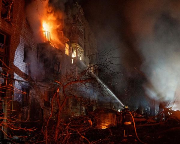
The destruction in Panama City, Florida – in pictures


Updated
Hurricane Michael has been downgraded to a category 1 storm. As of 8pm, the hurricane had maximum sustained wind speeds of 90 mph, which places it into category 1 on the Saffir-Simpson hurricane wind scale, which is how the National Hurricane Center determines hurricane categories.
How do you determine what category a hurricane is? Through the Saffir-Simpson Hurricane Wind Scale.https://t.co/PVM3kbCtPB pic.twitter.com/I9nazz6qq2
— Kate Lyons (@MsKateLyons) October 11, 2018
Updated
Is climate change making hurricanes worse? The short answer is yes.
The Guardian’s Daniel Levitt and Niko Kommenda have built this interactive to show the worrying long-term picture. They write:
Two common measures used to judge whether hurricanes are becoming worse are the number of storms per year and the strength of each storm. Based on the total number of named storms, there has been an increase since the start of the 20th century.
Category 5 hurricanes are the most severe but also the most rare – there have been just three in the past decade.
But these hurricanes aren’t the only category of storm that cause significant damage. Hurricane Harvey showed us last year that a category 4 storm can last for several days and dump historic volumes of rain to almost sink an entire city.
To more accurately assess how bad a storm is, meteorologists use the Accumulated Cyclone Energy Index – or ACE – to account for the strength, frequency and duration of storms per year. The Atlantic Ocean is in the midst of its worst stretch on record.
View the full interactive here.
Authorities have warned motorists to stay off the roads even after the storm has passed, warning that in one stretch of Thomasville Road in Tallahassee alone, there are more than a dozen downed utility poles.
This mangled utility pole is just one of more than a dozen lying along Thomasville Road north of I-10 rn. 😯 https://t.co/RPgaJZfMjg
— City of Tallahassee (@COTNews) October 10, 2018
What we know so far
- Hurricane Michael, the strongest storm to ever hit the Florida Panhandle, was upgraded to a category 4 hurricane in the early hours of Wednesday morning as it approached the coast of Florida.
- It made landfall on Wednesday at about lunchtime, near Mexico Beach, Florida with winds of 155 mph.
- One death has been reported, of a Florida man killed by a falling tree in Gadsden County.
- It is the strongest storm to hit the continental US is more than 25 years, since Hurricane Andrew devastated Florida in 1992.
- Trump has described the storm as a “monster” and acknowledged the poverty in the area hampered evacuation efforts, with thousands of residents staying in their homes.
- The sheriff of Franklin County, Franklin confirmed that a woman had been hit in the head by a falling tree limb. There are no ambulance services available and her condition is not clear.
- More than 311,000 homes and businesses in Florida, Georgia and Alabama are without power due to the hurricane.
- Hurricane Michael was downgraded to a category 2 storm on Wednesday night with maximum wind speeds of 10 mph.
Man killed by falling tree
Authorities say a Florida Panhandle man was killed by a falling tree as Hurricane Michael tore through the state.
Gadsden County Sheriff’s Office spokeswoman Anglie Hightower says they received a call around 6 pm Wednesday, saying a tree had crashed through the roof of the man’s Greenboro home and trapped him.
Emergency crews were heading to the home, but downed power lines and blocked roads were making the trip difficult.
Officials did not confirm the man’s name.
Hurricane Michael has been downgraded to a category 2 storm, with 100 mph maximum winds. When it made landfall roughly six hours ago it was a category four storm with sustained winds of 155 mph.
Wind speeds are: 67mph in Albany, Georgia, 61mph at Tallahassee international airport and 60mph in Dothan, Alabama.
Hi, this is Kate Lyons taking over from my colleague Patrick Greenfield. It’s now roughly 7:30pm in Tallahassee and I’ll be bringing you updates as the night continues.
Updated
Here is the full National Hurricane Center update.
Here is the 7 PM EDT position update for #Michael - Eye of #Michael moving through southwestern Georgia https://t.co/huazqXcQgJ pic.twitter.com/iJzibRVzQF
— National Hurricane Center (@NHC_Atlantic) October 10, 2018
Thousands lose power
Over 311,000 homes and businesses in Florida, Georgia and Alabama are without power because of the hurricane, according to local power companies. Michael is now a category 3 hurricane but raged through the Florida Panhandle as a Category 4. Outages could last for several days, authorities have been eager to show they are prepared for the cleanup.
Utility companies have nearly 19,000 personnel staged to begin power restoration. Getting power back on is absolutely critical to our recovery and response efforts- this is a top priority.
— Rick Scott (@FLGovScott) October 10, 2018
We are assisting linemen and tree surgeons stage from all over the Southeast. As soon as it is safe to do so, they will be headed to the panhandle. Help will be on the way. #HurricaneMichael #Michael #Teamwork pic.twitter.com/dnpy21bEeG
— Jax Sheriff's Office (@JSOPIO) October 10, 2018
Meanwhile, the National Hurricane Center says the storm is now about 35 miles west-southwest of Albany Georgia, with maximum sustained winds of 100mph.

Updated
The National Hurricane Center says the eye of Michael is now moving over Seminole county in southwestern Georgia. The storm surge along the coast of the Florida Panhandle is also a big concern, with reports of floods nearly 5ft deep.
Heavy rainfall from #Michael could produce life-threatening flash
— National Hurricane Center (@NHC_Atlantic) October 10, 2018
flooding from the Florida Panhandle & Big Bend regions into
portions of southeast Alabama, Georgia, the Carolinas, and southeast
Virginia. See the latest @NWSWPC forecasts for more details: https://t.co/3qxGBA9w6t pic.twitter.com/lsGXGrMq73
Here’s a photo of the hurricane from space.
The eye of #HurricaneMichael before the storm made landfall on the Florida panhandle. This image was taken by @AstroSerena around noon on Oct. 10, 2018 as the @Space_Station orbited over the Gulf of Mexico. pic.twitter.com/Bj8Te1voET
— NASA Astromaterials (@Astromaterials) October 10, 2018
Our reporter Jamiles Lartey is hunkered down off I-10 in Marianna Florida, where Michael’s eye passed directly over. He sends this in via SMS, as the storm has all but knocked out mobile internet access.
It was around 3:00 PM in Marianna when the most brutal part of Michael passed over this Florida town. The wind whipped and howled, bowing windows and stripping roofing off the buildings in a small corridor of hotels off RT 71. Flash floods waters pooled as trees swayed and splintered, somehow mostly managing to stay upright as they shed branches and leaves. Then, in a matter of minutes, an eerie calm. Folks walked into the streets to survey damage as the sky lightened. “How’s the car?” one man screamed across a hotel parking lot. “Fine I guess” his wife yells back. Across the street, the clearing visibility reveals that a high sitting sign for Microtel, at least 40ft up, didn’t survive the winds. Its panels are gone and its frame sits crooked.
Some walk dogs who have been stuck inside for hours as the storm slowly wound up over the course of the day.
Then the light sprinkle quickened, the sky got dark again and the still gave way to more gusts as the other side of the eyewall began to pass over. “Round two” said Jason Evans, a Marianna resident as he sighed and walked back inside. As the winds picked back up, glass could be heard shattering every few minutes, though it was unclear the source. Several windows did break at hotels along the way as undermanned staff tried to quickly board them before the eye wall’s encore.
Updated
President Trump has continued campaigning for the midterms despite the hurricane. He’s been at a rally in Erie, Pennsylvania and said it would have been “very unfair” to cancel the event for his supporters.

Couldn’t let these great people down. They have been lined up since last night - see you soon Pennsylvania! pic.twitter.com/jSrsmncw85
— Donald J. Trump (@realDonaldTrump) October 10, 2018
Updated
ABC anchor David Muir has posted a video from his hotel room in Panama City, Florida, where he says the wind blew out a window.
View from my room. Window blew out - stunning flooding. Panama City. #hurricanemichael2018 pic.twitter.com/wybgoSQ1R7
— David Muir (@DavidMuir) October 10, 2018
FEMA are reminding people to find safe places to shelter as the hurricane heads inland towards Georgia where falling trees could pose a danger in strong winds.
It’s extremely important to keep sheltering in a safe place and to stay aware as #Michael continues to move inland! https://t.co/pGvp1bzxal
— FEMA (@fema) October 10, 2018
Here’s a video that shows the hurricane’s devastating power. Hurricane Hunters shot a video above the eye of the storm earlier today.
A pilot’s view of the eye wall of #HurricaneMichael from an Air Force Reserve Hurricane Hunter mission today. (U.S. Air Force photo by Lt. Col. Sean Cross, 53rd Weather Reconnaissance Squadron pilot.) pic.twitter.com/df6Ll3nLz0
— Hurricane Hunters (@53rdWRS) October 10, 2018
Hello to wherever you’re joining us from. I’m Patrick Greenfield and I’m taking over coverage from Erin.
Hurricane Michael, the third most powerful storm to ever hit the US mainland, has made landfall in Florida. Videos on social media show hug waves and widespread damage along the Gulf of Mexico coastline in the state.
Here are two more eye-popping images of #HurricaneMichael seen from #GOESEast today. Left image shows the Cat. 4 #hurricane making landfall. Right image shows Michael's precipitation shield at 3:30 pm ET as the storm began moving inland. Latest: https://t.co/4ehlTVpig1 pic.twitter.com/RMme5qVWJ1
— NOAA Satellites (@NOAASatellites) October 10, 2018
I’ll be posting developments as nighttime falls in the areas affected by the storm.
Updated
Hurricane Michael has been downgraded to a category 3 hurricane and its eye is now approaching southeast Alabama and southwest Georgia.
The storm is moving at 16 mph as of 4pm, according to the National Hurricane Center, and its sustained winds are at 125mph.
Michael is expected to move across southeastern Alabama and southwestern Georgia through Wednesday evening.
Lifeguards had to save three children who were playing in the water at a South Carolina beach as the storm approached, the Associated Press reported.
A 15-year-old and two 9-year-olds were playing on boogie boards off Hilton Head Island around 12:15pm when waves whipped up by the storm pulled them away from shore, according to Beaufort County Emergency Management Division Commander Neil Baxley.
Responders were able to safely rescue the kids.
The number of households without power is now up to 118,789, according to Gulf Power.
That’s more than a quarter of the total customers in the service area.
Officials say crews will work to restore power as soon as possible, but cannot start while the storm continues to rage.
With its 155mph winds at landfall, Hurricane Michael is the strongest storm to hit the continental US since Hurricane Andrew devastated south Florida in 1992.
History is made. #Michael pic.twitter.com/yomz0Zq70M
— Hurricane Tracker App (@hurrtrackerapp) October 10, 2018
Radar data indicate that the eye of Michael is now moving inland over portions of Jackson County in the Florida Panhandle and is nearing Interstate 10, according to the National Hurricane Center.
The storm has weakened only slightly as it moves over land, with sustained winds at 140 mph.
Life-threatening storm surge and catastrophic winds continue, the center says.
Florida is prepared to deploy 1 million gallons of water, 1.5 million Meals Ready-to-Eat and 400,000 pounds of ice to aid storm victims, Gov. Rick Scott said.
Updated
A downed tree limb broke through a window and hit a woman in the head in Franklin County, Florida, the county’s sheriff said.
Sheriff AJ Smith told CNN authorities received a 911 call about the injury, but ambulances had evacuated and were not able to respond. Officials in multiple jurisdictions had previously warned that emergency services would be unavailable at the height of the storm.
“We had no EMS to go treat her,” Smith said. “City police did the best they could.”
The woman’s condition was not clear.
Power is out across Franklin County, and many large trees are down, the sheriff said.
Updated
There’s severe damage in Mexico Beach, Florida near where the hurricane made landfall. Homes are fully submerged.
A look at what houses in #Mexico Beach, #Florida look like right now. This is a follow up from the previous clip posted. They are now submerged and were no match for #HurricaneMichael (via Tessa Talarico) #Hurricane #Michael #HurricaneMichael2018 pic.twitter.com/GJENrhFJha
— Josh Benson (@WFLAJosh) October 10, 2018
Damage from Hurricane #Michael in Mexico Beach, FL. #flwx https://t.co/bUz1WBsf7U
— NWS Tallahassee (@NWSTallahassee) October 10, 2018
Extensive damage was also spotted in Panama City.
Hurricane #Michael damage pictures starting to come in from the Panama City, FL area. #flwx https://t.co/1UQy7omUhy
— NWS Tallahassee (@NWSTallahassee) October 10, 2018
Updated
The eye of Michael is moving inland over portions of Bay and Calhoun counties in the Florida Panhandle, per the 3pm update from the National Hurricane Center.
“Everyone in these areas is reminded not to venture out into the relative calm of the eye, as hazardous winds will increase very quickly as the eye passes!” the center wrote.
Wind gusts have been reported as high as 119mph at Tyndall Air Force Base outside Panama City.
Updated
Our Jamiles Lartey dropped by the Kindel Lanes bowling alley in Marianna, Florida, where owner Jeff Kindelspire invited his neighbors, who live in mobile homes, to join him and ride out the storm.
A group of a half dozen neighbors were munching on burgers and watching storm news on TV.
“We’ve got soda and snacks and cards, and we can survive in here without power for up to a week,” Kindlespire said.
Mobile home residents are some of the most vulnerable when hurricanes hit... But it's less daunting when, like Jeff Kindelspire, you also own a local bowling alley. He invited some of his neighbors to ride out the storm with him at Kindel Lanes like he's been doing since 1980. pic.twitter.com/pOwU8ywVXp
— Jamiles Lartey (@JamilesLartey) October 10, 2018
While the panhandle is taking the hardest hit, other parts of Florida are also seeing the effects of the storm.
There’s been some flooding in the Tampa Bay area, more than 300 miles from where the storm’s eye made landfall.
Images posted by a Tampa Bay Times reporter show flooded streets in Tarpon Springs and rising water in New Port Richey, both cities north of Tampa. Flooding could get worse when high tide arrives.
And streets are starting to flood in Tarpon Springs. This is Dodecanese Blvd. @TB_Times pic.twitter.com/yhWTRh9c7y
— Jack Evans (@JackHEvans) October 10, 2018
An hour and a half or so before high tide, the water is coming up here in a New Port Richey neighborhood by the Pithlachascotee River — several neighbors parking cars on one piece of high ground pic.twitter.com/nYuRmAyAxM
— Jack Evans (@JackHEvans) October 10, 2018
It’s one of 21 Waffle House locations in the storm’s path that have shut down, WMBF News reported.
Updated
Everything in Marianna, Florida closed down for the storm, the Guardian’s Jamiles Lartey reports – including the local Waffle House.
That’s a bad sign: Fema informally uses a “Waffle House Index” to determine the likely scale of assistance required for disaster recovery, since the restaurant often stays open when others close.
The Waffle House is also closed. Bad News. FEMA informally uses a "Waffle House Index" to determine the likely scale of assistance required for disaster recovery. Waffle Houses often stay open when other restaurants close, and can be a refuge for hungry patrons. #HurricaneMichael pic.twitter.com/NByCYzMWzW
— Jamiles Lartey (@JamilesLartey) October 10, 2018
Updated
Hurricane Michael makes landfall
Hurricane Michael has made landfall near Mexico Beach, Florida, the National Hurricane Center says.
The storm is still intensifying as it makes landfall. It now carries sustained winds of 155 mph.
Hurricane #Michael has made landfall just northwest of Mexico Beach, Florida. The latest public advisory is available on the NHC website: https://t.co/fniXaEmxWe pic.twitter.com/s4X21XtdX1
— National Hurricane Center (@NHC_Atlantic) October 10, 2018

Updated
Here’s a view of the eye of Michael from outer space, shared by a US astronaut.
A view of the eye of #HurricaneMichael from @AstroSerena, currently orbiting Earth on the @Space_Station: https://t.co/NbHRW0j0mj
— NASA (@NASA) October 10, 2018
Landfall of the eye of Hurricane Michael is “imminent”, says the latest update from the National Hurricane Center.
The eyewall is coming ashore along the coast of the Florida Panhandle between St Vincent Island and Panama City.
“Everyone in the landfall area is reminded not to venture out into the relative calm of the eye, as hazardous winds will increase very quickly as the eye passes!” the center said.
A wind gust of 106mph has been recorded in Port St Joe. Water levels are rising fast, with 6.5ft of inundation above ground level reported at a station in Apalachicola.
Here is the 12 PM CDT position update for #Michael: Eyewall of Michael coming ashore along the coast of the Florida Panhandle between St. Vincent Island and Panama City. Do not venture out into the eye when it passes! pic.twitter.com/KsePFlnTIt
— National Hurricane Center (@NHC_Atlantic) October 10, 2018
Updated
There are now 77,874 households without power, according to an outage map from Gulf Power.
The biggest outages are in the area around Panama City, with more than 73,000 customers with electricity out.
There are also outages in the areas around Pensacola and Destin, with power expected to go out for thousands more as the storm hits.
Donald Trump says he will likely go forward with a campaign rally planned for Wednesday night in Pennsylvania despite the storm.
He said he would travel to the affected area later, likely Sunday or Monday.
“There are thousands of people already lined up, and probably we’ll do that tonight,” Trump said in a White House briefing when asked if he would cancel the rally planned in Erie, Pennsylvania. “You have so many people already there, and it’s sort of not fair to them.”
Trump said he would head to hard hit areas “as soon as possible” but did not want to get in the way of immediate response efforts.
“I don’t want to go down where we’re interfering with the people,” he said.
Updated
Trump: 'It grew into a monster'
Fema administrator Brock Long and homeland security secretary Kirstjen Nielsen briefed Donald Trump on the hurricane at the White House.
“This started out very innocently a week ago. This was a small storm,” Trump said. “It grew into a monster.”
Long told the president that structures built before 2001 are not designed to handle the storm’s 145mph winds, meaning there will be “a lot of devastation along the coast structurally”. Extended power outages are expected.

Trump marveled at the size and strength of the storm, which is the most intense to strike the area since 1851.
The fast movement of the storm meant that “citizens have less time to prepare or heed the warnings”, Long said. “We are concerned that many citizens chose not to heed those warnings, but we’re prepared with search and rescue teams.”
Trump acknowledged that poverty in the area has held back evacuation efforts. “It’s not so easy for some of these people to leave. Some of the areas are very poor,” he said. “A lot of people are very poor ... And it’s very tough for them to leave.”
Updated
Video posted by meteorologist Marc Weinberg shows a newly constructed building collapsing in heavy wind in Panama City Beach.
New construction just collapsed in front of me in Panama City Beach from #hurricanemichael!!! It is going bad fast! pic.twitter.com/CG5R8jcUuf
— Marc Weinberg (@MarcWeinbergWX) October 10, 2018
During an emergency few things are more critical than cell phone service. For the majority of US households, cell reception is their only means of communication with the outside world when wired internet goes down, and their primary means of obtaining important safety information.
What happens when the power that those cell phone rely on gets interrupted?
Meet Christian Hall, James Risi and Kim Key, who set up at a mobile staging ground in Marianna, Florida, to restore downed cell towers for AT&T, one of the US’s two largest cellphone carriers. “We’ll sit here and wait the storm out and as soon as the storm passes we’ll just start slingin’ em out,” said Hall, an event coordinator for Infinity Communications.
He notes that the importance of restoring the networks is twofold. For one, there’s “the emotional wealth of being able to call your loved ones and find they’re doing alright”, but more urgently, cell reception is a literal lifeline. “The other system that we support is those E911 calls, and those [emergency calls] require an active and stable network.”
We chat in a command trailer parked in the lot of a decommissioned fuel station. There are dozens of 4x4 trucks here and swarm of contractors huddle under the awning as the wind whips a light rain sideways at them. Hall says the crew have about 80 generators on hand to restore power to cell towers that lose power, and a boat is on the way.
“A lot of these sites you don’t even know exist,” Hall adds. “Some of them are on top of buildings, some are on water towers, some are hidden on top of [cellphone retail] stores,” meaning the crews need to be ready for all types of different jobs and to improvise ways to get access.
“Downed trees, down power lines and flooding are the biggest impediments,” Hall said.
But mostly they make quick work of it. Last year during Hurricane Irma, Hall said he was part of a team that got 500 of 1,200 downed sites back up on the first day alone.
“It rolls once it starts going,” said Hall. Over the last few years, the trio say they’ve also been deployed to Hurricanes Harvey, Nate and Florence just a couple weeks ago.

Updated
Hurricane Michael has gotten even stronger – with sustained winds now reaching 150mph, according to another update from the National Hurricane Center.
And the National Weather Service in Tallahassee says it has issued its first-ever “extreme wind warning”.
“Shelter in place IMMEDIATELY,” the agency warned.
The situation is about to get serious in parts of Bay, Gulf, and Franklin county. We've issued our first ever Extreme Wind Warning. This means wind gusts in excess of 130 MPH are expected as #HurricaneMichael makes landfall in the next few hours. Shelter in place IMMEDIATELY. pic.twitter.com/5nHmcKLGm0
— NWS Tallahassee (@NWSTallahassee) October 10, 2018
Updated
The town of Mexico Beach, Florida has lost power, its mayor said.
The town of 1,200 people is now seeing sustained winds of 40-50mph with gusts over 60mph, Mayor Al Cathey told CNN.
“It certainly is deteriorating rapidly here,” he said.
Out of 1,200 residents, 280 are still in town and did not evacuate, Cathey said.
“Not everyone left. We’re just hoping for the best here,” he said.
The core of the “extremely dangerous” Hurricane Michael was closing in on the Florida Panhandle, the National Hurricane Center said in its 11am update.
Life-threatening storm surge, hurricane force winds and heavy rainfall are “imminent”.
The storm is now 60 miles south-west of Panama City, with sustained winds of 145mph. It’s moving toward the coast at 14mph.
“Some strengthening is still possible before landfall,” the NHC said.
Updated
Here’s an update from Richard Luscombe in Miami:
Storm experts at AccuWeather are predicting that the bill for damages and the economic fall-out of Hurricane Michael could be close to $30bn.
“The greatest impacts will be near and east of where the hurricane’s eye makes landfall and particularly along the coastline because of angry seas in a dangerous storm surge being driven inland by onshore winds,” said AccuWeather president Dr Joel Myers, warning that damage from the storm might change a portion of Florida’s Panhandle coast “for decades to come”.
Among the economic fallout will be the rebuilding of properties destroyed or damaged by storm surge and high winds, including some that were already impacted in the Carolinas by Hurricane Florence last month. And increases in premiums for homeowners and auto insurance could cost consumers significantly in the years to come, AccuWeather says, as insurers reset rates based on claims experience.
By contrast, the two costliest hurricanes in US history were Katrina in 2005, which devastated New Orleans, and last year’s Hurricane Harvey, which caused massive flooding in Texas and Lousiana, according to the National Hurricane Centre’s list of costliest tropical cyclones, which estimates both at $125bn. Hurricane Irma, a category 4 storm that ripped through the Florida Keys and along the state’s west coast last year, caused damage estimated at $50bn.
Updated
Here’s a map showing the projected path of Hurricane Michael.
Photos sent to the Tallahassee Democrat show flooded streets and falling tree branches in Apalachicola, Florida.
Photos and videos I received from Seth Silva who lives on 4th Avenue in Apalachicola. You can see in the first photo that Avenue I is floooded and in the second, tree branches are falling. pic.twitter.com/JxQqlLQzSA
— Tori Schneider (@photoriphy) October 10, 2018
Hurricane Michael’s first strong band is now rolling through Tallahassee and the surrounding areas, according to the National Weather Service, with gusts of wind at 60mph.
#Michael First strong band is rolling through Tallahassee and surrounding areas as it moves off to the north and west. Expect strong winds with gusts around 60 mph. #HurricaneMichael pic.twitter.com/ETMuUg3k5O
— NWS Tallahassee (@NWSTallahassee) October 10, 2018
Updated
Hathaway Bridge, the main bridge connecting Panama City to neighboring Panama City Beach, has been closed due to winds over 50mph.
Here’s an image of rising waters in the area of the bridge.
According to https://t.co/MFFLrWdzld this is the east site of the Hathaway Bridge along US98 by the Simpson Boat Ramp. Follow @BayCountyEM for the latest information in Bay County. https://t.co/CxfJCVszh0
— NWS Tallahassee (@NWSTallahassee) October 10, 2018
The Bay county sheriff says the bridge is too dangerous to cross.
Because of deteriorating weather conditions due to Hurricane Michael, The Florida Highway Patrol has deemed Hathaway Bridge as too dangerous to cross. It is closed. Please DO NOT attempt to get out onto Bay County roads. There is a Shelter in Place order for Bay County.
— Bay County Sheriff (@BayCountySO) October 10, 2018
Updated
Tropical storm conditions are now spreading across the Florida Panhandle as Michael approaches, the National Hurricane Center says in its latest update issued at 10am eastern time.
Water levels are rising quickly along the coast of the panhandle. A National Ocean Service water level station at Apalachicola recently reported over 4ft of inundation above ground level.
The storm is now located about 65 miles south-west of Panama City, with sustained winds of 145mph.
A private weather station in Bald Point, Florida, has already reported a sustained wind of 48mph and wind gust of 59mph, and the Apalachicola airport also reported a wind gust of 58mph.
Updated
The storm has forced air traffic to re-route around the Gulf of Mexico.
#Michael has forced traffic to reroute around the Gulf of Mexico. The two main Florida <> points west airways, Q100 and Q102, have the storm right through them. This is traffic out of IAH and DFW going to MIA/PBI/FLL at the moment. pic.twitter.com/4VySCh6mYW
— Ethan Klapper (@ethanklapper) October 10, 2018
Updated
Water has begun to swamp some highways in Florida. The Florida department of transportation posted a video of storm surge topping a sea wall and flowing onto US 98 in Gulf county.
Surge from Hurricane Michael at Stump Hole on US 98 in Gulf County has intensified in the past 12 hours. pic.twitter.com/58w1KjaFAn
— FDOT District 3 (@MyFDOT_NWFL) October 10, 2018
Another photo shows flood waters encroaching on US 98 in Franklin county.
Storm activity is intensifying along the coastal areas with this area of US 98 just east of SR 65 near Franklin County School. pic.twitter.com/jghNE219cT
— FDOT District 3 (@MyFDOT_NWFL) October 10, 2018
Updated
Georgia is also expected to absorb a blow from Hurricane Michael, Federal Emergency Management Agency (Fema) administrator Brock Long warned at a press conference Wednesday morning.
He said the storm will be one of the worst that southern Georgia has seen in decades, and people there should “wake up and pay attention”.
In parts of Georgia, as in Florida, it’s likely power will be out for several weeks, he said.
North and South Carolina are also expected to see rainfall from the storm, which is a concern because rivers there have not yet receded to their normal levels after flooding from Hurricane Florence. “Unfortunately it’s going to be a reality and it’s going to cause problems,” Long said.
Updated
Water is rising in Rock Landing, Florida, according to the National Weather Service.
Storm surge picture from this morning around 6:30am near Rock Landing Florida (near Panacea). Can't stress this enough, these impacts from the surge is only the beginning, it's going to get higher! #Surge #FLwx #HurricaneMichael pic.twitter.com/9JHSV6syhM
— NWS Tallahassee (@NWSTallahassee) October 10, 2018
There may be tornadoes embedded in the hurricane, the weather service says.
We are closely monitoring couplets in #HurricaneMichael that may contain embedded tornadoes. Please pay attention to the latest warnings from our office and be ready to take action. #Michael #FLwx pic.twitter.com/lesYuxKux7
— NWS Tallahassee (@NWSTallahassee) October 10, 2018
With rain already drenching the area from the fast-moving storm, officials are warning residents Wednesday morning not to try to move if they haven’t already evacuated.
“What we’re trying to communicate to our folks is: You’ve made your decision. It’s time to hunker down and ride out this storm,” Tallahassee mayor Andrew Gillum told CNN.
Panama City Beach city manager Mario Gisbert said residents should take shelter in the least exposed room in their homes.
“Find a good, safe room within the house – typically it’s a closet, it’s a bathroom, it’s a hallway. If you’ve got an area where you’ve got water rising, just play it safe – try not to travel in that water,” he told CNN. “Stay at home. Stay in a dry spot and just weather it out right now. It’s not the time to move.”
Some reports suggested that many of those encouraged to evacuate had ignored the warnings and chosen to stay put. There were mandatory evacuation orders in place for Panama City Beach and Pensacola Beach, but not the city of Pensacola itself.
“I am not seeing the level of traffic on the roadways that I would expect when we’ve called for the evacuation of 75% of this county,” Bay county sheriff Tommy Ford told the Associated Press
Updated
“Communities are going to see unimaginable devastation,” Florida governor Rick Scott said at a storm press conference Wednesday morning.
Medical teams are standing by, with 90 ambulances at the ready, Scott said. There are 19,000 workers stage to help restore power after the storm.
There are not yet any major power outages or fuel shortages.
“Hurricane Michael is forecast to be the most destructive storm to hit the panhandle in a century,” Scott said. Twelve inches of rain could fall in parts of the panhandle. “Flooding will be a major issue,” he said.
The storm came on fast, unlike Hurricane Florence which lingered off the east coast for days, leaving less time for officials to prepare.
Scott said he had visited Franklin county, where 50 people had decided to stay put on an island off the coast despite visits from law enforcement to encourage them to evacuate. “I’m scared to death for them,” Scott said.

Updated
Florida governor Rick Scott says he has just spoken with Donald Trump, who offered federal aid to deal with the massive storm.
Just spoke with @POTUS to give him an update on Hurricane Michael. He offered any federal resources necessary as we prepare to respond to this massive and catastrophic storm.
— Rick Scott (@FLGovScott) October 10, 2018
Florida governor: 'This storm can kill you'
Hurricane Michael strengthened overnight into a dangerous category 4 hurricane, and is headed for Florida – the strongest storm to ever hit the Florida Panhandle.
“This storm can kill you,” Governor Rick Scott has warned.
The hurricane is expected to make landfall Wednesday, with population centers like Panama City and Tallahassee sitting in its path.
The “potentially catastrophic” storm has sustained winds of 145mph, the National Hurricane Center said in its latest update.
Storm surge could reach up to 14ft in parts of the hurricane zone.
The hurricane is 90 miles south-west of Panama City as of 8am eastern time.
Half a million people were advised to evacuate, but officials said Wednesday morning that it was too late to flee and residents who haven’t already left should hunker down.
“The time for evacuating along the coast has come and gone. First responders will not be able to come out in the middle of the storm. If you chose to stay in an evacuation zone, you must SEEK REFUGE IMMEDIATELY,” Scott tweeted.
The time for evacuating along the coast has come and gone. First responders will not be able to come out in the middle of the storm. If you chose to stay in an evacuation zone, you must SEEK REFUGE IMMEDIATELY.
— Rick Scott (@FLGovScott) October 10, 2018
We will have live updates here throughout the day.
Updated