NASA has sent the Sentinel 6B satellite into orbit in a mission scientists say will define how the world understands the planet's rising seas. The launch unfolded against an unusual backdrop, as California endured days of torrential rainfall that left even mission meteorologists stunned.
Standing at Space Launch Complex 4 East at Vandenberg Space Force Base, the SpaceX Falcon 9 rocket roared to life at 12:21 a.m. EST on Monday, November 17, which was 9:21 p.m. Pacific time on Sunday.
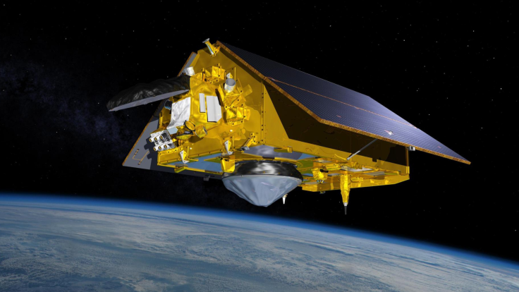
The spacecraft, part of a £760 million (1 billion dollar) international partnership between NASA and Europe, is designed to deliver the most precise picture yet of how Earth's oceans are changing.
'One of the Wettest Places in the United States'
The drama began long before ignition, as weather officers struggled to determine if the launch could proceed at all. The weekend brought relentless storms along the West Coast, drenching the launch site in conditions rarely seen in the region.
Launch Weather Officer First Lieutenant William F Harbin captured the shock when he briefed reporters.
'California has been one of the wettest places in the United States this weekend, even wetter than, say, the Midwest, which is really abnormal for Southern California,' Harbin told a pre-launch news conference Saturday.
The downpours were so intense that NASA warned of a 60% chance that weather rules would be violated, threatening to halt the launch.
Yet the skies opened just long enough. With less than perfect but acceptable weather, the Falcon 9 climbed through a damp coastal haze and carried Sentinel 6B into the night.
A Precision Mission to Measure a Changing Ocean
NASA confirmed successful separation of the satellite 57 minutes after liftoff. Once deployed, Sentinel 6B settled into an orbit 830 miles above Earth, inclined 66 degrees to the equator. The spacecraft weighs 1,192 kilograms, or 2,628 pounds, and carries advanced scientific instruments capable of mapping sea surface height to within about one inch.
NASA's own launch statement described Sentinel 6B as an Earth observing satellite that will observe the ocean and measure sea level rise to provide insights into our home planet that will improve weather forecasts and flood predictions, safeguard public safety and protect coastal infrastructure.
The agency underscored that Sentinel 6B joins its twin, Sentinel 6 Michael Freilich, which launched five years earlier from the same base.
The satellite will become the new reference standard for global ocean height measurements, continuing a record that began with TOPEX Poseidon in 1992 and has remained unbroken for more than three decades.
A Global Partnership With a High-Stakes Purpose
Sentinel 6B is the result of a major collaboration involving NASA, the European Space Agency, EUMETSAT, NOAA, the European Commission and CNES.
Airbus Defence and Space in Germany constructed the spacecraft. The United States and Europe shared the cost equally, reflecting a long-standing scientific alliance built around accurate ocean observation.
NASA's Launch Services Program at Kennedy Space Center managed the launch, marking the programme's 108th complete end to end mission. The agency provided live coverage on NASA+, Amazon Prime and NASA.gov, drawing thousands of viewers eager to watch the spacecraft begin its journey.
Yeah that's not why. It's a spy satellite, looks like a suppository which is how we are all feeling about inflation.
— Netta Johnson-Barnetta Johnson (@johnson_netta) November 17, 2025
'Final Warning From Space' or Just a Satellite?
As Sentinel 6B begins its mission, scientists emphasise the value of long-term measurement. The satellite will serve as the reference altimeter that helps calibrate other missions, ensuring that sea level data remain consistent for at least the next five years.
The archive this mission extends is now more than 30 years old and is considered vital for understanding global trends.
But outside scientific circles, public reaction has been mixed. Some online voices have described the satellite as a final warning from space, a machine collecting evidence that governments would rather not confront directly. Others applaud NASA's technical focus and insist that reliable data must stay separate from political rhetoric.
Whatever the opinion, the stakes are immense. After launch, Sentinel 6B will undergo calibration before taking over operational duties from its twin. Its measurements will support coastal planners, emergency response teams, shipping authorities and researchers worldwide.
Can we:
— BLESS AMERICA (@PunishingU2) November 17, 2025
MAKE NASA HONEST AGAIN?
You can start by releasing the
UN-EDITED VIDEO OF
3 I ATLAS
UAP DISCLOSURE
A Launch That Felt Like a Message
For many watching from the storm-battered California coast, the symbolism was impossible to ignore. An ocean-level satellite launched from a region experiencing rare, intense rainfall.
A mission built to measure rising seas took flight just as the planet reminded everyone that the atmosphere and the oceans are changing in real time.
What rose from Vandenberg that night was not only a spacecraft but a signal. Sentinel 6B will spend the next five years sending home precise measurements of a world in flux.
Whether viewed as a scientific instrument or a warning from orbit, its data will shape how nations prepare for the future.