LOS ANGELES _ Residents in parts of Southern California's Antelope Valley have been ordered to evacuate as the Bobcat fire is now within one mile of the Juniper Hills community and is burning downhill toward Devil's Punchbowl county park, officials said Thursday afternoon.
The order applies to Juniper Hills, Devil's Punchbowl and Paradise Springs, including the area east of Devil's Punchbowl Road, south of Big Pines Highway, north of Big Rock Creek and west of Jackson Lake, according to the Los Angeles County Sheriff's Department. Residents in the surrounding areas remain under an evacuation warning.
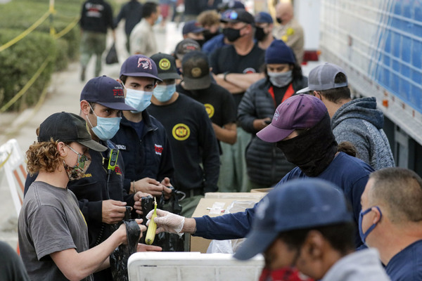
Fire officials say residents who have been ordered to evacuate should quickly gather family members and pets and head outside the fire evacuation zones. People in need of assistance can call the Red Cross at (800) 675-5799. Accommodations for 300 horses and cattle are available at the Antelope Valley fairgrounds, officials said.
Los Angeles County Fire Capt. David Dantic said the fire was approaching residences in Juniper Hills and that at least 12 air tankers had been requested for immediate structure protection.
Dantic said that crews knew the fire was moving in that direction, "but it had more activity than we thought."
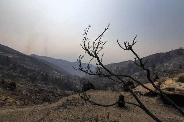
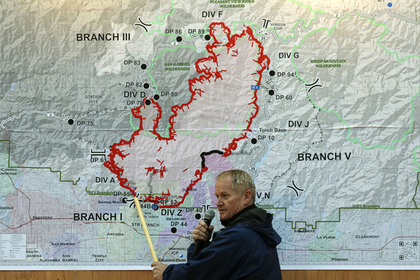
The Bobcat fire, which started Sept. 6, remains at 3% containment and has grown steadily in multiple directions. Officials say the spread is caused by a combination of bone-dry vegetation and rugged topography that makes it hard to fight the fire.
"Our canyons have a tendency to run north and south, so if a 15- to 20-mph wind reaches that, it's enough _ with the driest fuels we've had in a long time _ to really drive the fire," Angeles National Forest spokesman Andrew Mitchell said Thursday.
Nearly 1,300 personnel have been assigned to the blaze, up from just over 1,100 Wednesday, and crews have gained some control over its southern end _ which was a top priority for days due because of its proximity to several foothill communities.
"Right now, we feel like we've closed the 'front door' of this fire," Mitchell said, referring to the southern perimeter. Evacuation orders for portions of Arcadia and Sierra Madre were lifted Wednesday, although residents are being urged to stay vigilant and alert should fire conditions change.
Similar evacuation warnings remain in place for Monrovia, Bradbury, Altadena, Duarte and Pasadena.
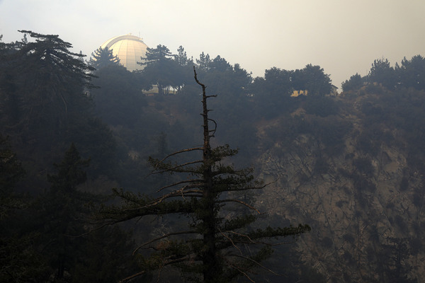
The top priority for Thursday is the continued protection of the Mount Wilson Observatory as well as a huge spot fire in the northeast where the blaze jumped Highway 2 in the Angeles National Forest, Mitchell said.
Mount Wilson is not only an important piece of history, but also home to several broadcast towers. Crews were able to keep the blaze from reaching the observatory Tuesday, when flames came within 500 feet of the structure, but officials say they are not out of the woods yet.
"It made a significant run (Wednesday) when the fire hit a string of conifer trees and started pushing up to the lookout in Skyline Park," Mitchell said, adding that he saw flames as high as 30 feet.
The fire is also showing growth on the north side in Cooper Canyon, which is expanding into the Pleasant View Wilderness, and near the Crystal Lake area and the West Fork, where officials said there is heavy fuel.
The Bobcat fire, along with the El Dorado fire in San Bernardino and a slew of fires in Central and Northern California, Oregon and Washington, is also contributing to dreadful air quality in Southern California.
Smoke advisories were extended through Thursday _ the 11th straight day for such air quality alerts _ and forecasts for the area range from "unhealthy" to "very unhealthy," according to the South Coast Air Quality Management District.
"I left to stay with a friend in another neighborhood because the air was so poor and hard to breathe," Pasadena resident Erin Greeson said.
A virtual community meeting with fire management hosted by the Angeles National Forest was scheduled for Thursday evening.
A previous online meeting left some frustrated when it was capped at 500 participants, so the latest session will be live-streamed on YouTube for anyone who cannot join via Zoom, Mitchell said. The meeting can be accessed via Angeles National Forest's Twitter and Facebook accounts.
Fire officials don't expect full containment of the Bobcat fire for at least six weeks.