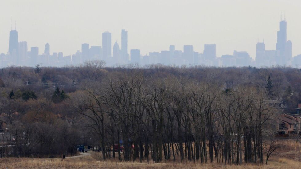
Research by Northwestern University scientists has identified air pollution hot spots around Chicago, shedding light on pollution’s disproportionate impact in different parts of the city.
They found that neighborhoods near Chicago expressways and Lake Michigan have a higher concentration of air pollution.
The research, published in the Journal of Geophysical Research: Atmospheres, found the highest levels of ozone over Lake Michigan. So lakeside neighborhoods have the highest concentrations of ground-level ozone — formed by nitrogen oxides and volatile organic compounds in the presence of sunlight. Lake breezes carry those pollutants from the city over the water, where they form ozone.
The researchers found that neighborhoods next to expressways experience the highest levels of some air pollutants — twice the concentration of those that areas with the lowest pollution levels in Chicago have.
The Northwestern scientists used mathematical equations to simulate chemical and physical reactions, pulled emissions data from the U.S. Environmental Protection Agency and looked at building types, land cover and weather to create a computer model to track hour-by-hour levels of nitrogen dioxide, ozone and particulate matter 2.5 — a pollutant made of tiny bits of contaminants and chemicals.
The model reveals pollution across blocks of space as small as nearly one mile. They said their simulation is the first to show neighborhood-scale pollution in the Chicago area by combining chemical models and high-resolution emissions data.
The EPA is required to monitor these pollutants, but sensors around Chicago are sparsely distributed and don’t capture the whole picture, said Anastasia Montgomery, a Northwestern doctoral student and lead author of the study.
Montgomery said this “means that we’re able to capture areas with high pollution that the monitors do not observe.”
An analysis last year by WBEZ, the Chicago Sun-Times and MuckRock identified air pollution hot spots in Englewood, Little Village, Austin, Irving Park, Avondale and Auburn-Gresham using data from 94 sensors installed around the city. But even 100 or more sensors wouldn’t be enough to cover the entire city, the report said, making it harder to analyze the Southeast Side and Far South Side, areas hit hard by air pollution.
Montgomery said the tool can simulate how air pollution might change due to weather patterns or policy changes.
“We can ask the model to show us how the same time period may look with a specific policy in place,” she said. “We can simulate the same week, pre- and post-policy.”
Particulate matter 2.5 and nitrogen dioxide are associated with industrial and vehicular emissions, a problem in Chicago, a major freight and trucking hub.
Ozone, particulate matter 2.5 and nitrogen dioxide have been linked to asthma, respiratory infections and premature death and are especially harmful to children, the elderly and people with health problems.
City Hall’s “2020 Air Quality and Health” report estimated that 5% of premature deaths a year in Chicago are linked to particulate matter 2.5.
Jose Acosta-Cordova, senior transportation policy analyst with the Little Village Environmental Justice Organization, said expressways often run through communities of color, with warehouses and distribution centers located nearby for easy access for diesel trucks that spew pollutants.
“The people who live around these facilities disproportionately are people of color, African American, Latino and Asian communities,” Acosta-Cordova said. “We suffer disproportionately from poor air quality, from other health-related issues that are created as a result of that air pollution.”
In the 2020 report, city officials acknowledged the impacts of air pollution are magnified disproportionately by structural racism and historic disinvestment in Black and Latino communities.
Last July, the U.S Department of Housing and Urban Development found that City Hall is violating peoples’ civil rights by helping shift polluting businesses from white communities to Black and Latino areas. HUD demanded the city revise zoning, planning and land-use policies in an effort to stop discriminating against communities of color.
Acosta-Cordova said research like Northwestern’s is “really helpful in terms of showing what we’ve been telling the city for years — that this is an issue that’s primarily impacting our communities.”
Montgomery wants to explore how high-resolution mapping can incorporate data on healthcare access and health outcomes to try to quantify the impact of pollution and inform policy decisions.
“Now, we can talk about, you know, where pollution is coming from but also how can we make it better for people and how do these plans benefit people?” Montgomery said.