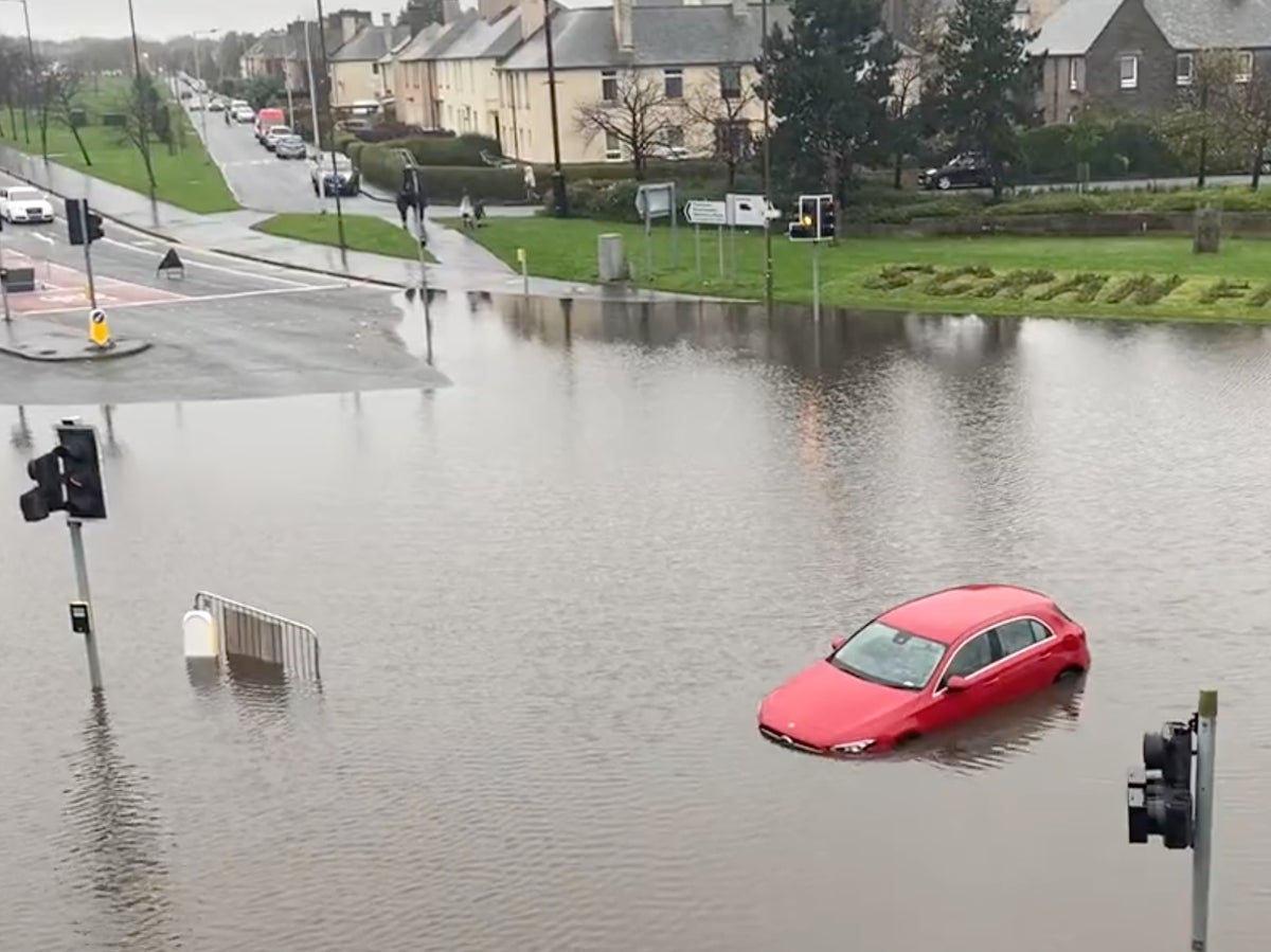
People have been stranded in their homes and forced to abandon their submerged cars, as “danger to life” flood warnings were extended in Scotland.
Rail travel across much of Scotland was brought to a standstill as officials braced for river levels to reach record highs on Friday, with schools closed and “rest centres” set up for those in hard-hit Aberdeenshire who had been unable to return to their flooded homes.
Police Scotland said on Friday evening that the emergency services were in attendance at the River Don, where it is believed a person may have got into difficulty while trying to rescue a dog.
Dramatic footage and images also showed at least one driver losing control of a car in deep floodwater at a normally busy road junction in the capital Edinburgh. Parts of the M92 to Dundee and M9 to Stirling were among those brought to a standstill by the conditions.
Forecasters warned that around 100ml of rain was expected to fall in parts of the country from Thursday until Friday evening – rising to upwards of 150ml in the Grampian Mountains. Overnight on Thursday alone, 140mm of rain – more than a month’s worth – fell in Charr in Aberdeenshire.
But while some parts of Scotland had experienced nearly a month’s worth of rainfall already this week, the same again was expected over the course of Friday and Saturday in parts of the northeast, said Vincent Fitzsimons, flood duty manager for the Scottish Environment Protection Agency (Sepa).
Met Office weather alerts stretched nearly the length of Scotland on Friday, from the English border to Elgin.
A severe amber warning was in place until 9pm, covering an area running from Aberdeenshire to just north of Dundee, where meteorologists warned of a “danger to life from fast-flowing or deep floodwater”.
Sepa warned of “widespread flooding affecting whole communities”, large scale evacuations, and the “collapse of buildings and loss of infrastructure” in the most severely hit areas.
Scottish justice secretary Keith Brown convened a meeting of Holyrood’s resilience committee – equivalent to Westminster’s emergency Cobra committee – on Friday evening, amid warnings that some of the worst impacts could still be felt on Saturday.
Mr Fitzsimons of Sepa told BBC Scotland: “Rivers are rising and will continue to rise through the course of Friday. Some of these rivers won’t peak until early Saturday morning.”
He added: “The event in the northeast is similar in magnitude to that of Storm Frank in 2016. Some parts of the northeast won’t be hit quite as badly as Storm Frank but some will be worse, and some rivers by the end of the day will have seen record high flows.”
Urging people that it is “extremely dangerous” to attempt to drive or walk through floods, Mr Fitzsimons said: “We had an exceptionally dry summer and we’re now experiencing a very wet November so this is exactly the kind of situation that the climate change predictions have been giving us.”
Among the locations hardest hit by the deluge on Friday was Ballater – the Aberdeenshire town which bore the brunt of the damage caused by Storm Frank.
Surrounding rivers, the Dee and the Muick, reportedly burst their banks and rainwater streamed from the hills, with residents filmed using buckets to tip floodwater from their gardens and police going door-to-door urging people to evacuate overnight.
Rest centres were opened in Ballater, Aboyne, Inverurie and Kemnay for those needing help and who are unable to stay in their homes.
Andrew McIntosh, who lives in the Fife town of Cupar, said that the floods had left him and his father – who suffers from a severe lung condition – stuck in their home with only partial power. He added: “We’ve only got electricity upstairs, and I’ve got medication that has to be in the fridge. It’s a nightmare and nobody has been around to assist or help.”
Dundee and Edinburgh also saw major road closures due to the flooding on Friday, while Newcastle, Sunderland, Gatehead, and Doncaster were among places facing disruptions to rail networks, metro lines, roads and bus services.

Hundreds of people were left stranded at Newcastle Station due to the cancelled services north to Scotland. Those waiting in the huge queues for replacement buses were told that they may have to wait up to five hours to board.
Met Office spokesperson Stephen Dixon warned that gusts could blow in excess of 50 knots later on Friday, while temperatures are expected to drop, going as low as -4C in Northern Ireland. “Fairly widespread frost is possible for much of the UK,” he added.
While Saturday will be largely clear, Sunday sees another front of rain and heavy wind moving in from the West bringing the chance of thunder and lightning, Mr Dixon said, adding: “That sets up what is really the theme of the next week which is continued wet and windy weather for much of the UK.”
Additional reporting by PA