KERI: The danger of heavy mudflow from the landslide that took place 10 days ago in Satrem is looming over many villages of Sattari. Forest areas that were cleared for agriculture and other activities in Parwad, Chikhale in Belgaum district and other neighbouring areas of Karnataka which border Goa brought a load of sediment from the heavy downpour at the height of monsoon.
This sediment load widened the cracks that developed due to instability and resulted in the landslide at Amyacho Gawal of Satrem on the way to Parwad via Chand-Surya ghat.
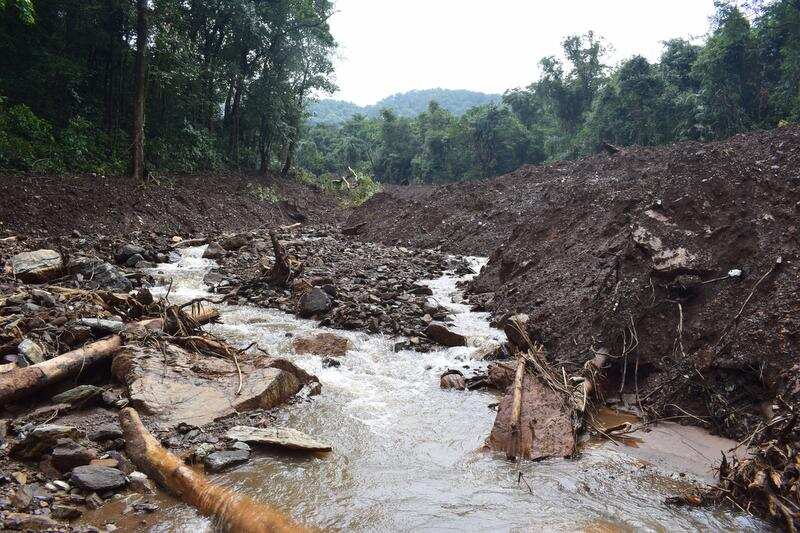
Gajanan Shetye, a wildlifer who visited the area said, “When rainwater which had collected in the ground in the upper reaches of the Kalasa river basin gushed down, it resulted in a surge of water-soaked rocks, earth, and debris and resulted in heavy landslide thereby destroying a forest cover stretch of almost 2kms in the Mhadei Wildlife Sanctuary.”
A seasonal nullah that used to emerge from the forests of the Amyacho Gawal has disappeared giving way to a new muddy nullah which is carrying heavy sediments in Sidhichi kond of the Kalasa river. On Sunday as per the directives of the government the Collector of north Goa Ajit Roy along with the officials of the disaster management cell visited the area where the landslide has occurred.
Chief engineer of the Water Resources Department (WRD), Pramod Badami told TOI, “We are in the process of taking the help of Geological Society of India to find out the exact reason for the landslide in Sattari. We have never experienced such a type of landslide in Sattari. A detailed geo-technical investigation is needed to be carried out. Along with other government departments we will take precautionary measures so that such incidents will be minimal.”
“From the landslide point, Parwad and Chikhale in Karnataka are situated at a distance of 3kms and 6kms respectively. The highest point in the vicinity is 578mts whereas landslides have taken place at the height of 350mts from mean sea level,” said Subodh Naik, a member of Vivekanand environment awareness brigade, Keri.
Deputy conservator of forests, wildlife north Goa division, Jabestin Arulraj told TOI, “As per the information given by our officials, a large patch of forests has been destroyed, uprooting many trees underneath. We will carry out the study of the landslide area with the help of drones and other gadgets. Our staff is visiting the area on a daily basis and relaying information of the ground realities.”
Villagers of Sattari who are living on either banks of the Kalasa (Surla) river that finally joins the Mhadei river at Uste in Sattari expressed fear that if no immediate mitigation measures are taken when heavy rain erodes the exposed mudflow, it will create inconveniences to the villages downstream.