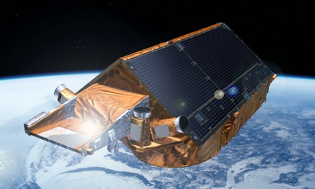
Five years ago this week, the European Space Agency’s CryoSat mission reached orbit, on its second attempt. CryoSat measures the thickness of polar ice, a key parameter in studies of climate change. Approved in 1999, the 750kg satellite was built during the opening years of the millennium and sent to Russia for launch.
On 8 October 2005, CryoSat took to the skies, but minutes into the ascent a bug in the flight control system meant the rocket did not shut down properly and the whole lot fell back to Earth, plunging into the Arctic Sea it was supposed to monitor.
ESA rebuilt the mission and tried again. This time, they chose a Dnepr rocket, which is a conversion of Russia’s most power intercontinental ballistic missile, the SS-18 Satan. The launch took place on 8 April 2010, and CryoSat-2 entered low Earth orbit to begin mapping the ice sheets using radar.
Flying at an altitude of 700km, CryoSat measures the height of ice sheets to an accuracy of less than a centimetre. It has shown that the average ice volume has been relatively stable over the last five years, but with large variations from year-to-year. Comparison with previous ice missions suggests that ice volume is shrinking. It is therefore important to continue monitoring to understand what is the accurate long-term trend.
CryoSat can also measure sea level. In December 2013, it registered a tsunami-like storm surge caused by high water eating through the Kattegat sea between Denmark and Sweden. This proved valuable for testing computer models of such storm surges.