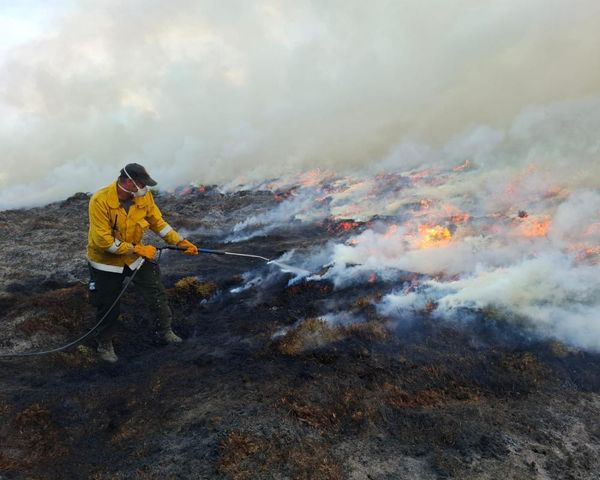
Cooler conditions are forecast to arrive across northern Queensland from tomorrow after a string of unseasonably warm days and nights that has led to several weather records broken across the far north.
Cairns sweltered through its warmest November minimum temperature in 14 years overnight, with the mercury not dropping below 26.7 Centigrades at the city's airport weather station.
For residents of almost 27,000 properties south of Cairns, the warm night was endured without power for almost two hours after a snake "interfered" with an electrical substation at Innisfail.
Shane Kennedy from the Bureau of Meteorology said a hot air mass had been sitting over northern Queensland for several days without strong winds to push it away, causing high humidity.
"It's unusual in both in its extent, seeing those daily records, but really the longevity is really quite unprecedented as well," he said.
A trough due to push off the Townsville coast tonight should bring some milder temperatures.
"It's not going to be a huge relief for the far north, unfortunately," Mr Kennedy said.
"But it should at least bring things back down to average compared to the well above average [temperatures] we've been seeing for the past couple of days."
Unusual October heat
Temperature records at Cairns Airport date back to 1942, and its three hottest Octobers in that time have now occurred in the past three years.
Last month's average daily top for the city was just short of last year's record of 31.9C.
Cairns Airport was one of several centres to record its warmest-ever average overnight minimum for October, along with Townsville, Cooktown, Kowanyama and Weipa.
Kowanyama, Lockhart River and Cooktown also recorded their warmest-ever average October maximum temperatures.
The warm conditions caused above-average sea surface temperatures on the Great Barrier Reef for most of the past week and beyond into the Coral Sea.
A weather station on Willis Island, about 400 kilometres off the coast, recorded its warmest-ever October minimum temperature overnight Monday at 27C.
The National Oceanic and Atmospheric Administration's outlook suggests there is a high probability of coral bleaching heat stress on the reef between now and January.
However, experts like Lissa Schindler from the Australian Marine Conservation Society do not believe the past week's warm weather poses a direct bleaching risk.
"But what we will start seeing as climate change increases and temperatures increase is that this will become more normal," Dr Schindler said.
"That we see elevated sea temperatures earlier in the year."
Hope for rain
Weipa, in western Cape York, recorded its hottest day in 30 years of records on Saturday with a top of 40.1C.
"What we've had the last couple of weeks shouldn't really be starting until the middle of November," Lyn Frost, from Weipa Camping Ground said.
"Yes, it's hot, but we're lucky we can offer them a swimming pool and a few shady spots they can camp at."
Ms Frost said visitors had still been coming through the town although the annual tourism slowdown had begun.
Like many residents, she is looking forward to wetter weather and hoping for a cyclone-free wet season.
"That would be my main wish," she said.
"Otherwise, bring on the rain."