A cold snap is pushing across the UK this week as forecasters warn of outbreaks of hail and thunder amid heavy showers.
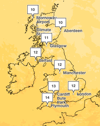
Temperatures are several degrees below the mid-May average across the midlands and northern areas on Wednesday as the country wakes up to a unsettled and blustery morning.
It comes as northerly winds drag in cold air from northern Scandinavia and the Arctic circle.
Average temperatures for the time of year range from around 12 to 17C across the country. But forecasters say the mercury will hover at around 14C in the south west and 9C in parts of Scotland at the warmest on Wednesday.
It has been an unsettled start to the day with blustery showers in the north and south east. The Met Office has warned wet conditions could turn thundery with a risk of heavy rain and hail in the east later in the afternoon.
However, sunshine is forecast in some areas, particularly in the west of England.
Wet and windy weather is expected to continue into Thursday as heavy showers are forecast across the east and west of England and Scotland. The Met Office said low pressure will become dominant, with showers expected to turn thundery in these areas and temperatures remaining cool.
The outlook for Friday and into the weekend is drier as showers are expected to clear, making way for some cloud and spots of sunshine. But temperatures are expected to remain cool until Sunday.
However, warmer weather is on the horizon. Met Office forecasters predict sunny conditions with temperatures to match by the end of next week, which could see the mercury hit above 20C in time for the bank holiday weekend.
Wednesday:
A blustery and cool day with a mixture of sunshine and showers. The showers heavy in places with a risk of hail and thunder, especially in the east. Showers also merging into bands to give some longer spells of rain.
Tonight:
A cool and breezy evening with further showers. Overnight some inland areas becoming dry with lengthy clear spells developing here
Thursday:
Another day of sunshine and showers, with the showers heavy and thundery in places. A more prolonged spell of rain possible for a time in the west. Feeling cool.
Outlook for Friday to Sunday:
Drier on Friday and Saturday with just a few showers, but remaining on the cool side. A band of rain then likely to move in from the west on Sunday.
Shock study reveals popular UK sandwich contains more salt than five cheeseburgers
Inside paratroopers expedition to remote Atlantic island to aid UK hantavirus patient
Shein takes rival Temu to court over alleged ‘industrial scale’ copyright breaches
Streeting arrives at No 10 for crunch talks with Starmer as unions pull support
Hantavirus: Ten Britons from remote islands to come to UK to isolate
Keir Starmer to meet key rival Wes Streeting amid open revolt in Labour Party