Story so far
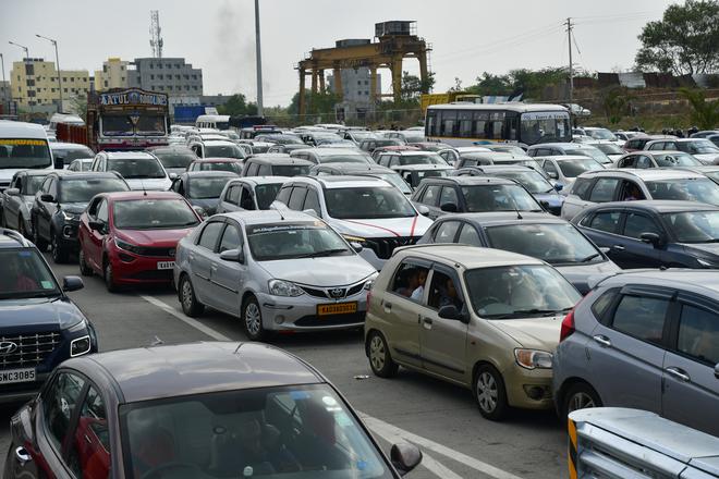
To monitor traffic in Bengaluru, the city traffic police have started to use drones fitted with cameras. For now, they have decided to monitor traffic through drones in eight congested locations in various parts of the city.
The drones will be given to various traffic DCP limits in the city, and they will deploy the drone cameras at Hebbal, Central Silk Board, Ibalur, Marathahalli, K.R. Puram, Goraguntepalya, Sarakki, and Banashankari bus stand.
Why drone to manage traffic?
According to city traffic police, drone cameras are used to get an aerial perspective of traffic congestion in the city and solve the traffic issues by adopting scientific solutions to decrease traffic snarls.
Speaking to The Hindu, City Police Commissioner B. Dayananda said, “Using drones will give better perceptive of the traffic issues to the police, especially on the flyovers and busy junctions in the city. By using drone cameras, our officials will get better inputs on the traffic congestion, and they can immediately act and solve traffic issues.”
Mr. Dayananda says that aerial view during peak hours will alert the officials on the exact reason for the cause of the traffic jam. “For instance, if there is a bus breakdown on the flyover, the drone camera will spot it, and our officials in the traffic management centre can alert the ground-level officials and take action immediately. Most of the time, the exact reason for the traffic jam will be known only after some time since the officials are not present on the flyover,” he explained.
What was the pilot project and how will it be scaled up?
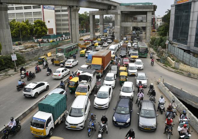
The traffic police have already procured two drone cameras and deployed them at Hebbal junction, which is a gateway for vehicles coming from National Highway 44 to enter the city.
Over the years, the city has expanded and vehicular population has increased drastically, and it has crossed the 1 crore mark. Importantly, the Hebbal junction, connecting Kempegowda International Airport (KIA), has resulted in increased usage of the flyover, turning it into a traffic gridlock.
Mr. Dayananda said that a drone camera has been deployed at Hebbal junction as a part of the trial run. “Further, we will deploy a few more drone cameras in four traffic divisions. We will procure additional drone cameras and deploy them on other congested roads,” he added.
Traffic police officials said that Hebbal junction was chosen for the trial run since it is one of the most traffic snarls-prone roads in the city. For more than a decade, the civic bodies and the State government have made multiple proposals to decongest the Hebbal junction. However, most of the projects either remained on paper or were halted midway through the work.
How will aerial footage help the police?
The Bengaluru traffic police will not just use drone cameras to identify traffic snarls and solve them on the day, but they are also planning to come up with a permanent solution for the traffic issues on particular junctions or roads by analysing the aerial footage taken every day.
Mr. Dayananda said, “Traffic police officials and experts at the Traffic Management Center will analyze the aerial footage collected every day. The officials will come up with solutions to the traffic issues and solve them after analyzing the footage.”
“Based on analysis of video footage daily, we will have first-hand data on the issues causing traffic jams and can come up with solutions like deployment of additional police personnel etc,” he said.
What do experts say on the project?
Ashish Verma, convener, IISc. Sustainable Transportation Lab, said, “More than using the drones, what is important is what will traffic police do with the data received from them and what analysis they can perform to understand traffic issues and solutions better. There may be some additional insights drones may give, compared to fixed cameras, because of its flexibility and providing a bird’s eye view.”
However, he added that if traffic police cannot do advanced analytics, a capability which traffic police department do not have, then they will not be able to do anything more or better, in terms of traffic management, compared to what they are doing currently.
What is the deadline set by government to address traffic issues?
Recently, in a review meeting, Home Minister G. Parameshwara set a deadline of three months to end the traffic problems in many pockets of Bengaluru.
Mr. Parameshwara told all Deputy Commissioner of Police rank officers to spend four hours every day on the roads during peak hours. He said that the tech city is infamous for its traffic, and he is on a mission to remove the tag. All DCPs, and ACPs should be on the field for four hours — two hours in the morning and two hours in the evening. “After three months, we should not receive traffic-related complaints from the public,” he instructed.
In what other ways can drones help?
Apart from monitoring traffic, the city police are planning to use drones to maintain law and order. Mr Parameshwara said that drones will be used in malls and busy streets to monitor safety.
Under various initiatives to make Bengaluru safe for women, he said that additional 20 safe islands would be set up, besides installing more than 2,000 surveillance cameras in crowded spaces and places frequented by women. This is part of the Union government’s safe city project that was launched in 2017-18.