There’s something interesting about the timing of this book: it arrives at a point when we are becoming untethered from the maps of our land. Drivers no longer see, even peripherally, details to the left or right of their highlighted route as fixed by their satnav; the idea of having an A-Z in the car, let alone using it, strikes an increasing number of people as rather quaint. You may as well keep a starter handle in the boot.
So perhaps this makes us more receptive to the idea behind the book: that there are alternative topographies, ways in which the UK has been mapped that do not consider the contours of the land, or the twisting of its roads, or even the boundaries between land and sea. Dr Joanne Parker, whose day job is senior lecturer in Victorian literature at the University of Exeter, has composed a short book based around five different ways of “imagining our relationship with the land that we live in”.
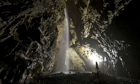
She starts with the land beneath our feet, with “the caver’s map of Britain”. Somewhat frustratingly, there isn’t an example of a map of a cave, there’s just a conventional map indicating the major caving sites. But the following chapter is eye-opening, and goes some way to explaining the lack of specific maps: cave systems are still being discovered and are often enormous; you could fit York Minster into Yorkshire’s Gaping Gill, which also contains Britain’s tallest unbroken waterfall, twice the height of Niagara.
After this Parker turns to the megalithic shape of Britain, and we suspect this is a subject close to her heart – her biography says she lives on Dartmoor, “next to a pub allegedly built around a standing stone” – but she doesn’t let her enthusiasm run away with her. This level-headedness serves her well, two chapters later, when she discusses ley lines and an astrologer says that when he stands in the paddock where he believes two ley lines meet, “it’s the psychic equivalent of a large Scotch”. He also says Milton Keynes is sited to take advantage of another ley intersection and “draw positive energy into the city”, an assertion that could be greeted with some scepticism, although who knows? After all, MK Dons had a good season last year.
Perhaps to accommodate readers who have been drumming their fingers during the chapter on ley lines, the megalith and ley line chapters are separated by a good historical overview of the UK’s remaining canal systems. After ley lines there is a chapter about invisible lines: the flight paths and regions that define Britain’s airspace. Here we go from the earliest balloon ascents – wayward affairs that could take you miles out to sea if you were unlucky – to the ins and outs of living near Heathrow (and don’t think that living miles away will save you from aircraft noise – just ask the people of Waltham Forest, living underneath the crossroads to the approach routes of Heathrow and City airports).
In the end, this is a book whose main purpose is as a spur to reflection and further thought. It could have been much larger. “For every chapter here, countless others could have been written,” Parker says. In her introduction she alludes to bird-watchers’ maps, sociological maps, climbers’ maps and the “five shadowy regions” of British prehistory, “each distinguished by regional fashions in crockery, ornaments, weapons and buildings”. In her afterword, she mentions other possibilities: the Arthurian map of Britain, the distribution of radon-affected areas, cold war nuclear shelters ... you could probably come up with a few ideas yourself. This is the fascination, virtue and charm of the book: it meanders and wanders in surprising directions, so that our minds can, too.
• To order Britannia Obscura for £7.99 (RRP £9.99) go to bookshop.theguardian.com or call 0330 333 6846. Free UK p&p over £10, online orders only. Phone orders min p&p of £1.99.