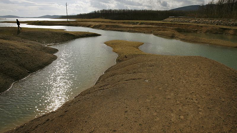
Water reservoirs in Attica, the Greek region encompassing Athens, are approaching historic lows, according to the latest analysis of the FloodHUB service of the BEYOND Operational Unit of IADET/EEA for the water supply system of Athens.
The research team identified that water supplies for the region are now under very high pressure due to the prolonged drought in recent years.
Attica's water supply system draws water from four main reservoirs: Mornos, Evinos, Yliki, and Marathon.
Mornos is the main source of supply, providing the largest amount of water consumed. The Evinos reinforces the Mornos through the Evinos-Mornos tunnel, acting as a transitional reservoir.
The Yliki - a natural lake - and Marathon are complementary to the two main reservoirs.
The FloodHUB service of the BEYOND Operational Unit of IAADET/EEA has assessed the hydrological and climatic conditions in the two main reservoirs supporting the Athens water supply system - the Mornos and the Evinos - in order to estimate the degree of hydrological stress and drought in the system for the first half of 2025.
It found that in the last year, the system appears to be under intense pressure, requiring immediate action from authorities.
How did experts analyse the status reservoirs supplying Athens?
Medium and high resolution Landsat-5,7,8 (1984-2021) and Sentinel-2 (2017-2025) satellite data were used for estimating the surface area of the lakes.
ERA5-Land climate data (1950-2025) allowed researchers to estimate monthly/daily climate variables for drought conditions and unusually hot days that increase evaporation.
Here's what they found out about the state of the reservoirs.
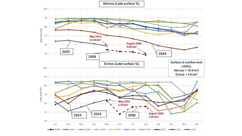
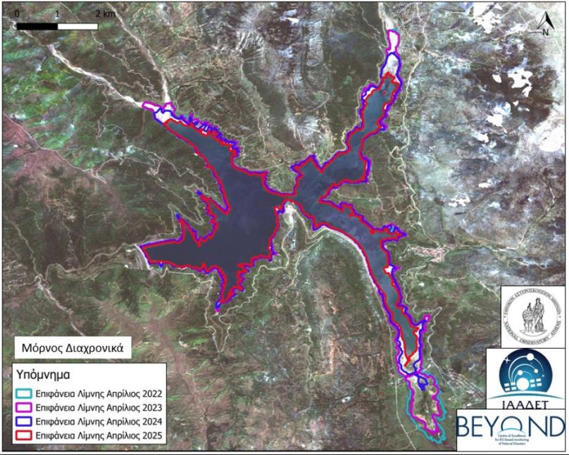
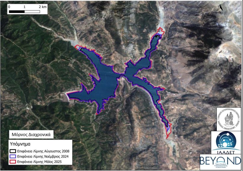
Evolution of the surface area of Lake Mornos
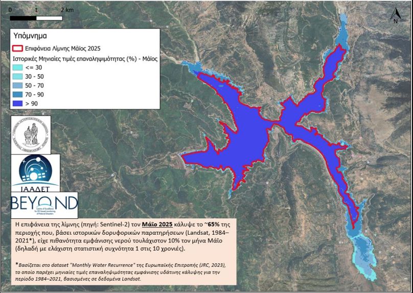
In May 2025, the surface of Lake Mornos covered only around 65 per cent of the (near) maximum area of depression based on historical data for the month of May.
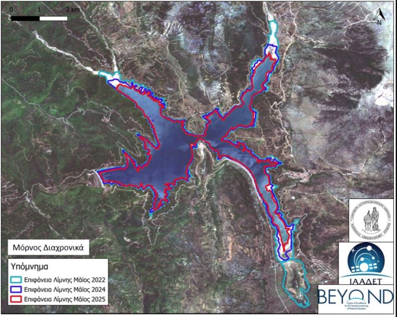
Similarly, in 2024 it was at 79 per cent, and in 2022 it had reached nearly 100 per cent.
The current 2025 value of around 11.64 km² is among the lowest observed since the Evinos reservoir was incorporated into the system in 2002, with the exception of the summer/fall of 2008, when the surface area dropped to less than 10 km².
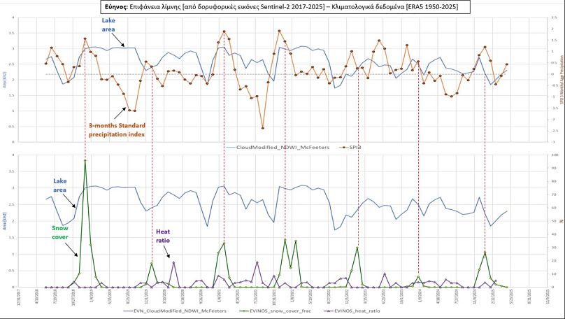
Evolution of the surface of Lake Evinos
In May 2025, the surface area of the lake was only 2.30 km², significantly below the surface area at the overflow level (3.6 km²).
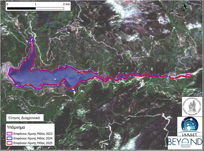
The 2024 values are correspondingly low, while other years, such as 2021 or 2022, show a much better picture.
Climatic conditions at Lake Mornu and Lake Evinos
In 2024, Lake Mornu saw low snow cover (snow cover of less than 10 per cent), very high heat stress (around 30 per cent), and low precipitation values (SPI-3 < 0, indicating hydrological drought). In 2025, there were slightly better conditions with SPI-3 precipitation index between -0.5 and +1, snow cover ratio around 20 per cent, and heat stress below 10 per cent.
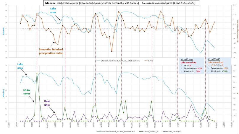
With similar climatic patterns to Morno, there was no evidence of statistically strong precipitation or significant reduction in drought at Lake Evinos.
Lake levels are approaching historic lows
Current reservoir conditions as of May 2025 indicate a retreat of the lake surface to the second-lowest levels in the last 20 years.
The 2008 period remains the worst hydrologically, but 2025 shows similar characteristics.
In recent years, the surface of the Mornos reservoir has shown a continuous downward trend. In 2025, compared to 2024, although the values of the precipitation index show a relative improvement, they are not sufficient to compensate for the decrease in the amount of stored water. Instead, there is a roughly 10 per cent decrease compared to 2024.
Evinus seems to be more strongly affected by drought conditions, due to its small storage volume.
The present situation as of early 2025 presents combined unfavourable conditions for the Evinos to Mornos system. Both reservoirs show significantly low filling levels of around 60 per cent, which exacerbates the level of hydrological stress in the system.
According to the above analysis, the system in the last year seems to be in a state of intense pressure, requiring immediate action from authorities.
Greece faces a growing water scarcity crisis. It ranked 19th worldwide for water shortage risk, according to a World Resources Institute study and a Deloitte report commissioned by the Greek government in May.
It found that the country faces severe challenges driven by tourism, agriculture, and ageing infrastructure.
What is the Beyond unit?
The Space Applications and Satellite Remote Sensing Unit (BEYOND) is a global operational unit, designed to identify hazards in a timely manner and protect societies, the environment and critical infrastructure from natural, man-made or near-space threats.
In particular, it provides standard continuous monitoring services for natural disasters in the wider region of South-Eastern Europe, the Balkans, the Middle East and North Africa, utilising large satellite data collection antenna infrastructures installed at the NSA.
Through the systematic activation of the Copernicus Emergency Management Services programme, BEYOND also serves the global community of Crisis Management Agencies and Services in a wide range of natural disasters.
The BEYOND operational unit specialises in monitoring natural disasters such as fires, extreme weather events, volcanic activity, landslides, soil erosion, water shortages, toxic industrial accidents, earthquakes, floods, and desert dust and smoke transport.