A nor’easter is expected to slam the East Coast this weekend, bringing pounding rainfall up to 10 inches and flooding coastal communities.
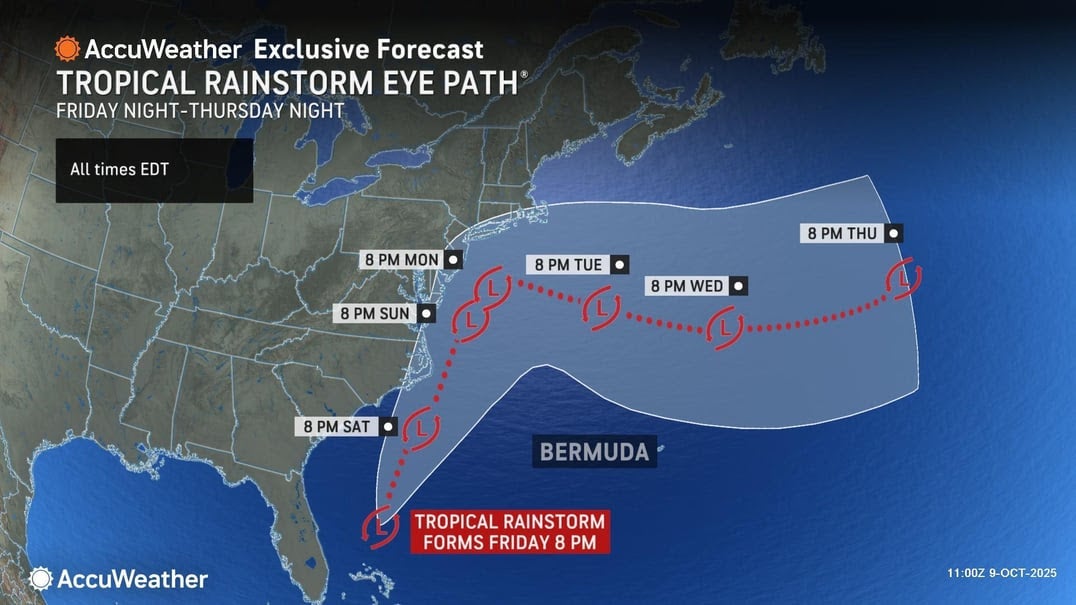
Forecasters said the low pressure system was anticipated to develop off the Carolinas late this week, with areas up to southern New England feeling impacts as soon as Friday and into next week.
"The storm will form just off the Georgia coast late this week and move northward this weekend to next week," AccuWeather Chief On-Air Meteorologist Bernie Rayno explained.
"As the storm drifts to the north, it will grow stronger each day,” he said.
One of the biggest concerns with the storm is heavy rain that could impact travel throughout the Northeast, Mid-Atlantic and New England.
Airports have already been affected by the government shutdown, leading to long lines and flight cancellations. But, they are expected to get even busier over the three-day weekend and ahead of Columbus Day.
Although most areas are projected to see at least two to four inches of rain, parts of New Jersey could get fives inches and the Outer Banks and Southern Virginia may see even more, according to CNN.
But rain isn’t the only possible flooding threat.
The National Weather Service warned of “significant coastal flooding impacts” from Thursday through the weekend for much of the East Coast – and October’s Harvest supermoon is partially to blame.
When the moon is closer to the Earth, its pull on our oceans is even stronger creating what are known as king tides, which are usually the highest tides of the year.
"The risk of major coastal impacts is amplified by the storm occurring toward the end of the ‘king tides,’ a time when tides are already running above their historical averages from an astronomical perspective," AccuWeather Chief Meteorologist Jon Porter noted.
High surf will also cause rip currents and erosion on many beaches, just days after the edges of what was Hurricane Imelda sent multiple Outer Banks houses tumbling into the Atlantic.
Collapses are caused by tides and strong winds, according to Fox Weather.
There could be as many as three feet of storm surge from Virginia Beach to New York City, according to AccuWeather.
The storm is also forecast to bring dangerous winds between 40 and 60 miles per hour whipping across the tri-state area.
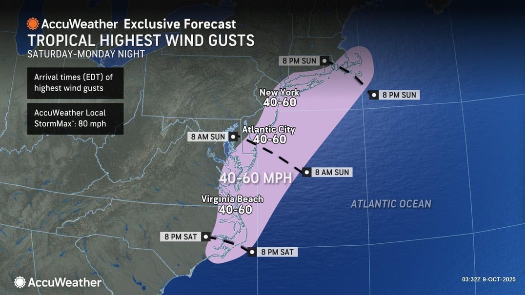
Those winds would be strong enough to cause significant property damage, knock down power lines and fell trees.
Although, notably, some other outlooks had forecast less aggressive impacts.
Matthew Wunsch, a forecaster with the New York City office of the National Weather Service, told The New York Times on Thursday that the storm wouldn’t be named. Its winds will be out of the northeast, which makes it a nor’easter.
But, it’s still going to be pretty impactful.
“Maybe more impactful than any kind of event that we’ve seen this season, at least up here,” he said.
Gaza latest: Israel announces when Hamas ceasefire will start after Trump deal signed
Passengers avoid US airports as mass flight delays continue
Watch live: Trump holds cabinet meeting after Israel-Hamas agree on Gaza plan
Ukraine war live: Zelensky will nominate Trump for Peace Prize if US sends Tomahawks
Traffic to Bari Weiss’ The Free Press soared before she was named CBS editor-in-chief
MTG ditches Fox News to join Wolf Blitzer and rip her party over health care shutdown