The appearance of a new staircase on what was once a bike path in Grey Lynn has local residents wondering what direction the council is going in when it comes to improving accessibility to public spaces
A project to make a central Auckland park more accessible has cut off a main route for prams, wheelchairs and e-bikes, raising questions about council planning processes from local residents.
Until very recently, the path into Bayfield Park and the adjoining Cox’s Bay Reserve in Grey Lynn from Hukanui Crescent was an accessible flat wooden bridge over a stream.
Upgrades to the Grey Lynn Greenway path over the past month have seen a staircase added to the bridge, cutting off access to a number of Aucklanders, including parents who use the path as a thoroughfare to a nearby kindergarten.
It’s raised eyebrows from locals in the area who watched as the destination point of the bridge was raised off the ground and widened as a part of the Greenways project, all the while wondering how it would be connected to their access pathway.
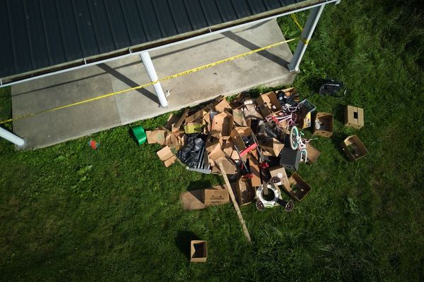
The end result is 10 steps with a narrow strip of metal bolted alongside the railing, presumably to aid cyclists in pushing their bikes up the stairs.
Local residents Stephen and Kate Lee live within spitting distance of the new staircase, which they called a “bizarre situation” the council surely couldn’t leave as is.
Stephen Lee said the renovation work on the reserve had been ongoing since around the beginning of the year, and workers had told him the bridge had somehow been forgotten in the grand plan.
“They raised the path up but they didn’t put much thought into what they would do with this path, so what they’ve done is they’ve just stuck 10 steps in its place,” Lee said.
It seems to be months of work spent making this public space more accessible, resulting in a neutral change or net loss of accessibility.
“There used to be two or three steps at the other bridge, which they’ve replaced, which is good now,” he said. “But there were no steps on this bridge and now they’ve replaced that with 10, so the overall effect is probably worse.”
On top of that, new raised pathing further into the reserve has been constructed over a drop of around 1.5 metres without any railings. Lee, an engineer, questions whether this is up to code.
He said he had put in a complaint via the council website, but heard nothing back.

The changes were part of the wider walking and cycling Greenways Plan from 2013. The plan highlights the need for accessibility for a range of modes of transport, saying “we want dedicated and connected cycleways and quality road design that rebalances the priority of road uses to all modes of travel - including cyclists, pedestrians, skaters and mobility scooters”.
However, it seems the execution of the plan has ended up with a popular connecting route cut off to most of those forms of transport.
Auckland Council senior project manager of operations Maisa Aldeen said the new Cox’s Bay Reserve to Wharf Road link provides a safe off-road walking and cycling connection for users to avoid the dangerous West End Road hill, with the main shared path accessible for all users including wheelchair, bike and pushchair through the beachside park.
However, raising the pathway in order to widen it produced what seems to have been an unforeseen snag - a two metre vertical drop between the greenway and the Hukanui Crescent bridge.
“Structure grade requirements for the new shared path meant the boardwalk height had to be increased. The option of a ramp to join the new boardwalk and existing bridge from Hukanui Crescent was explored but determined not feasible due to the angle of the slope,” said Aldeen. “Raising of the existing bridge to match the new boardwalk level was also not possible without raising the manhole lid level at the southern end of the bridge, requiring the alteration of a Watercare asset and not feasible within the project scope. A decision was made to upgrade the existing structure and to install a staircase with a bike ramp for greenways users.”
But local residents questioned the usability of the bike ramp. It's a thin strip of metal attached to the railing, close enough that a bike's pedals prevent easy use. And in the age of heavier e-bikes and rainy days, its utility fades somewhat.
Auckland Council head of area operations Julie Pickering said the council does everything it can to ensure new developments prioritise accessibility, but sometimes are prevented from installing ramps in situations like this due to feasibility.
“Sometimes we have to take practicality into the project regarding existing infrastructure and unfortunately with the Hukanui pedestrian bridge, due to existing infrastructure it was just not feasible to use a ramp,” she said.
The original plan for renovation of the reserve didn’t include renewal of the bridge - suggesting that somewhere during the construction process, somebody must have noticed the now 2m gap between bits of path and worked quickly to come up with a solution.
“The existing access from Hukanui Crescent is not deemed accessible and does not meet accessibility standards due to the narrow width of the path and the fact it has stairs,” Pickering said. “To increase accessibility, a ramp was designed to allow for accessibility from the bridge to the path, however the Watercare pipeline infrastructure could not support the size of the ramp required in order to comply with the building code accessibility guidelines.”
This was beyond the scope of the project’s budget and so a cheaper option had to be found - one that did not necessarily meet the stated goals of the Greenways project.
Pickering said the original plan is 10 years old and referred to as a scope, with design and work done according to today’s conditions, with accessibility held as a high priority.
“Where feasible we prioritise it into designs,” she said. “The overall scope on the Wharf Road to the Cox’s Bay shared pathway is now certainly a lot more accessible than it ever previously was.”
The area is certainly easier to access for people travelling along the Grey Lynn Greenway or from the northeast of Bayfield Park, but it’s not necessarily the truth for the residents of Hukanui and Parawai Crescents, especially those who push a pram or a wheelchair.
Local resident Jenny said she used to take her kids through in the buggy, but no more.
“It’s a steep long staircase, and dragging a buggy up it is quite hard,” she said. “It was a shortcut.”
Living nearby, she said she had been watching the “comic process” of the development going on while seeming to have forgotten about an entire connecting path.
“They fixed one bit, and made one bit worse,” she said. “It’s a couple steps forward, a couple steps backwards.”