As technology moves at the speed of light, we often hear that "there's an app for that." And while maps have been around for centuries, they've evolved to be more than just about navigation, or showing us where a place a place is. Nowadays, there are countless other maps that flip the script on how we see geography, culture, and history. Some challenge our assumptions. Others highlight hidden truths. Many teach us something we might not have known before. With the amount of maps available on paper and online, one could easily argue that "there's a map for that."
There's an online community dedicated to sharing the most interesting maps around. r/MapPorn has clocked up an impressive 5.9 million followers. They share fascinating and thought-provoking data in map form. Bored Panda has put together some of the most perspective-changing maps we could find on the page. Keep scrolling for a different kind of trip around the world and don't forget to upvote your favorites. We also spoke to cartophile and creator of Brilliant Maps, Ian Wright to learn more about how maps have evolved.
#1 The Great Wall Of China vs. Europe
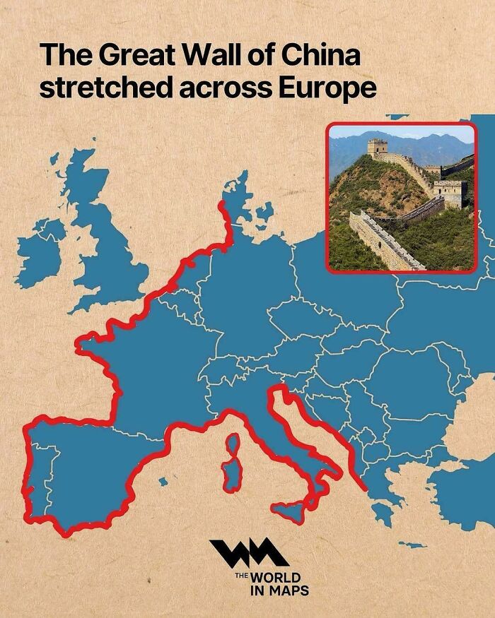
Image credits: ThunderWolf
You might be old enough to remember the days we would keep a paper map in the cubby of the car. Many were massive, and needed to be carefully unfolded in order for us to see the whole picture, and figure out how to get from Point A to Point B. Of course, there were, and still are map books. A little less bulky but still require some "map-reading" and navigation skill on your part, or you risk ending up on the opposite side of where you're meant to be.
The kids of today will never know the struggles, or joy, of holding an old, worn-out paper map in their hands while setting off on a great adventure. Nowadays, your car or mobile phone speaks to you. As confident as a co-driver during the Dakar Rally. Hell, nowadays, you'll even know whether there's traffic, an accident, or a roadblock on your route. And exactly where it is, how to avoid it, how long the new route will take based on your traveling speed.
#2 Bathymetry Of Great Lakes
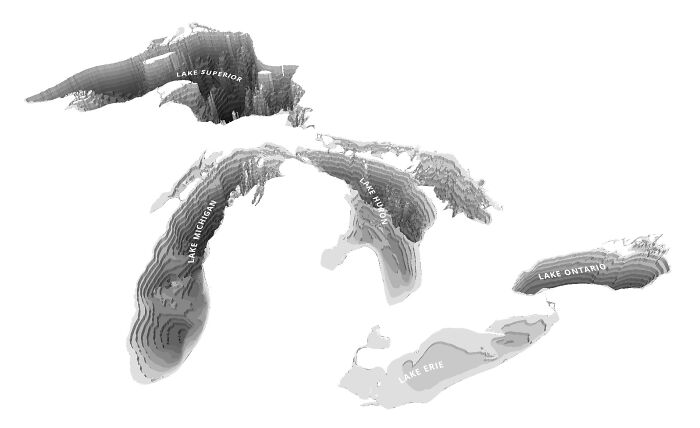
Image credits: multi_tasker01
#3 The World Divided Into 4 Equal Parts
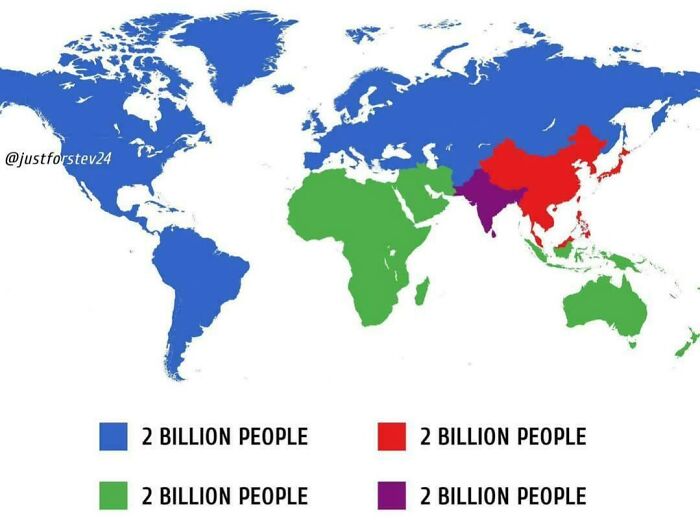
Image credits: Bobsytheking1
The world has indeed come a long way since our ancestors carved maps on clay tablets. Researchers say the earliest known maps date back to ancient Babylon around 600 BCE. And back then, they were based on the belief that the earth was flat, and one wrong step could send you tumbling off into oblivion.
Today, we have people like Ian Wright. He's the founder of Brilliant Maps, one of the most popular cartographic sites on the internet. We were thrilled when the self-professed cartophile agreed to have a chat with Bored Panda about the importance of maps, and whether they serve a purpose in the digital age.
"Maps are important not only because they help us navigate and give us a sense of place in the world but they can be the starting point of new adventures," Wright told us. "Plus, they can also be used to explain the world in a very easy to understand way."
#4 What Antarctica Looks Like Without Ice
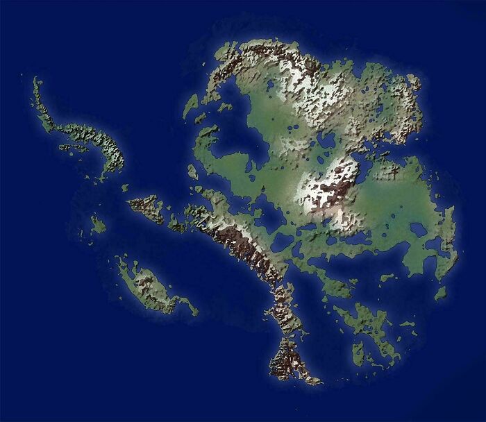
Image credits: vladgrinch
#5 How Many Hours Do Europeans Really Work?
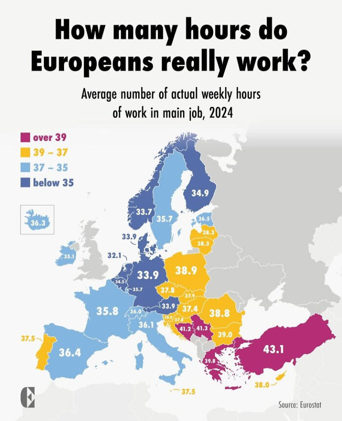
Image credits: Galixiiss1546
#6 70% Of Canadians Lives In 3 Areas
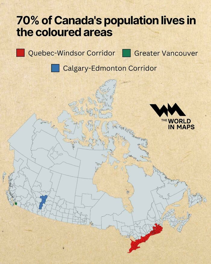
Image credits: rayg10
Wright's interest in maps was sparked when he decided to walk London's Tube map - above ground. He then started looking more into what makes the Tube map unique. And later started sharing various maps he’d found on Twitter, the former bluebird app now known as “X”. Today, his account has more than 129,000 followers and over 16,000 posts. He’s branched out and built a successful business around his passion for maps.
"I love maps because I think they're one of the best ways to learn about the world," Wright told Bored Panda during our interview. "They remain one of the best tools to explain the world to people." And the proof is in the list of maps you see while scrolling through this list.
#7 Africa In 10 Million Years
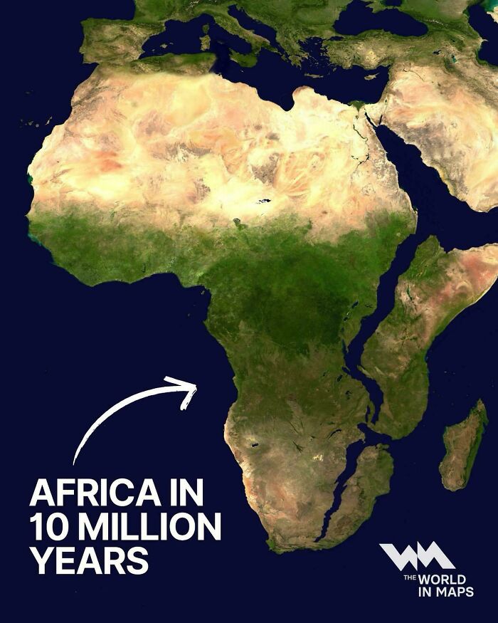
Image credits: LuckyTraveler88
#8 British English vs. American English: What’s Taught In Schools?
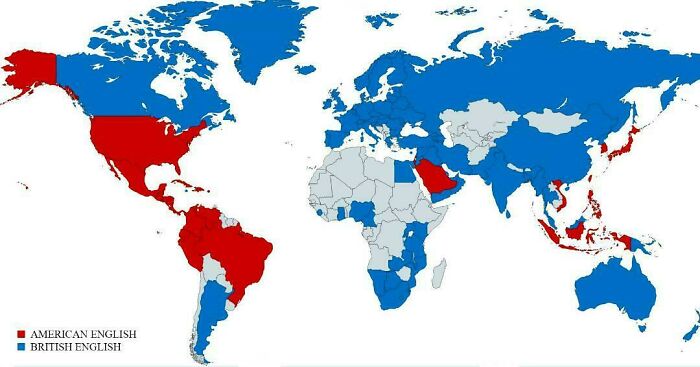
Image credits: vladgrinch
#9 People Who Believe The Government Is Hiding A Cure To Cancer
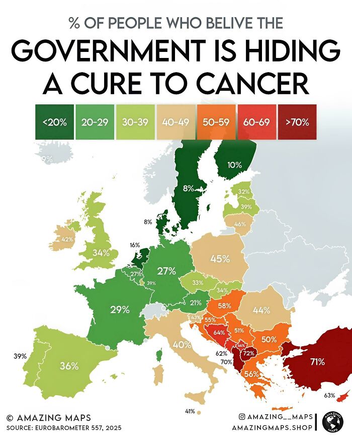
Image credits: LuckyTraveler88
"Maps can tell us lots of things beyond just where things are! They can show us the weather patterns, like where storms might hit or sunny spots to visit," says the cartophile. "Maps can also track fun things like animal migrations, popular foods in different regions, and historical events. Pretty much, if you can imagine it, there's probably a map for it!"
#10 68% Of Gaza Declared To Be Off-Limits To Gazans As Israel Expands Its Domination Of The Territory
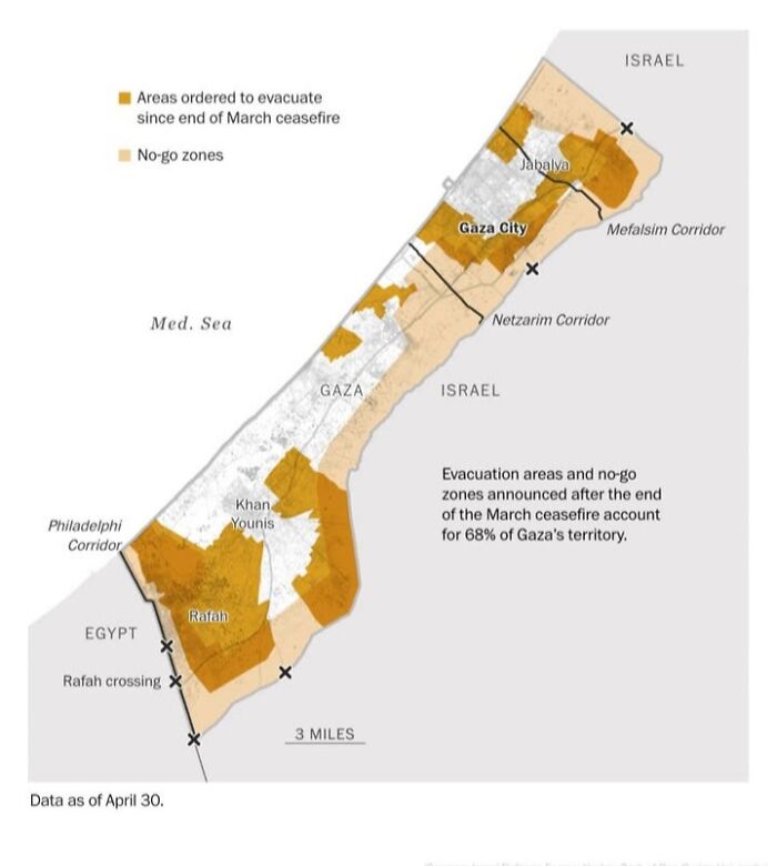
Image credits: Joshistotle
#11 Map Showing Countries Within Range Of Israel's Nuclear Missiles (Jericho III)
Image credits: Ok_Somewhere9687
#12 With Almost Every Vote Counted, Every State Shifted Toward The Republican Party
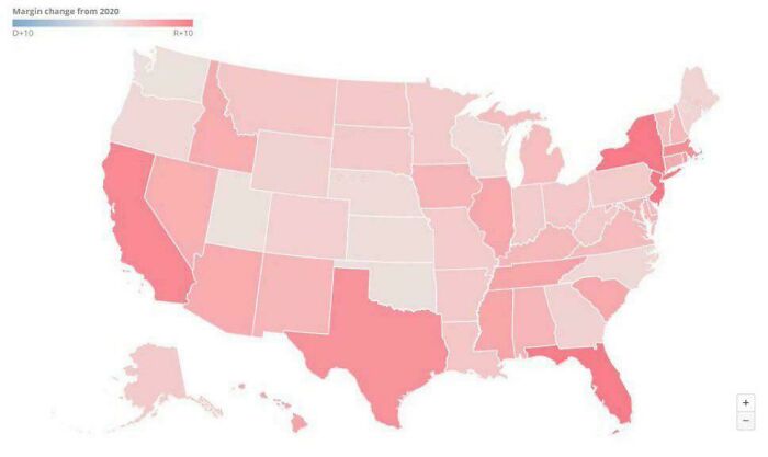
Image credits: EverestMaher
Bored Panda asked Wright whether he thinks paper maps still have a place in the world. Or are they about to be dead and gone? "Interestingly, I was just at a conference and paper maps are still going strong," he told us. "But the key for them in the long term is to create something personal and unique to the map buyer. So while generic paper maps might be on the way out, personalised ones are likely to be with us for the long haul."
#13 The Hippie Trail, Where Western Hippies Travelled Throughout The 60s And 70s Usually To Consume Drugs And Spiritual Awakening(Oc)

Image credits: Wally_Squash
#14 Holocaust Victims By Country
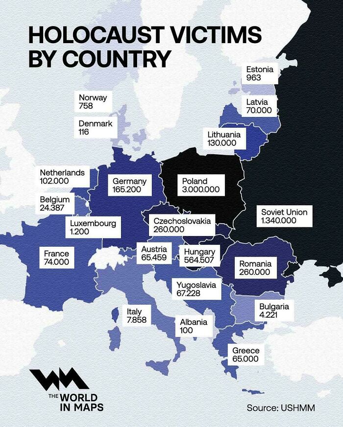
Image credits: vladgrinch
#15 UK's Largest Immigrant Communities By Region
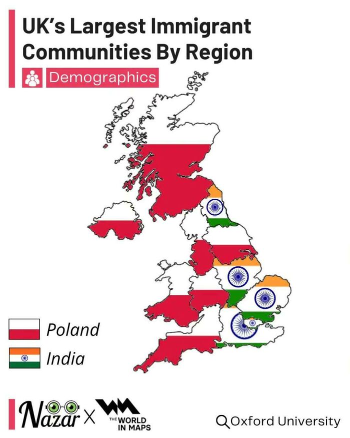
Image credits: vladgrinch
Wright is best known as the founder of the Brilliant Maps site and the subsequent book. But his journey is just beginning. "Beyond continuing to run BrilliantMaps.com, I also have two more books in the works," he revealed. "The first is a sequel to my best-seller Brilliant Maps: An Atlas For Curious Minds and the second will be a geography based trivia game."
#16 Who Wants To Join Eu The Most?
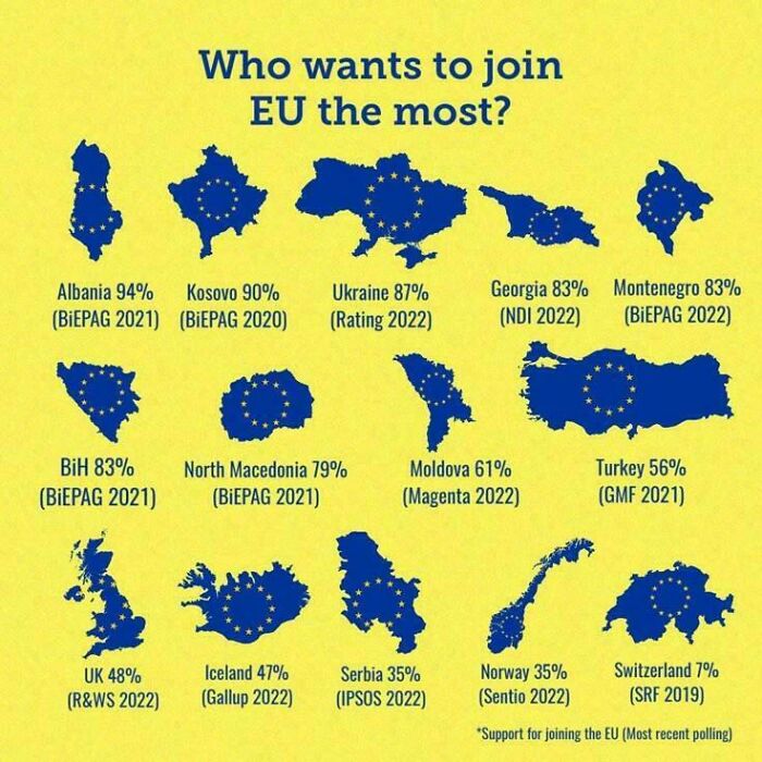
Image credits: SquareFroggo
#17 Vast Stretches Of The World Are Now Below The Replacement Rate. You Will Probably Live To See Humanity's Population Peak

Image credits: AmericaGreatness1776
#18 Where Did Jesus’s Disciples Go After This Picture:
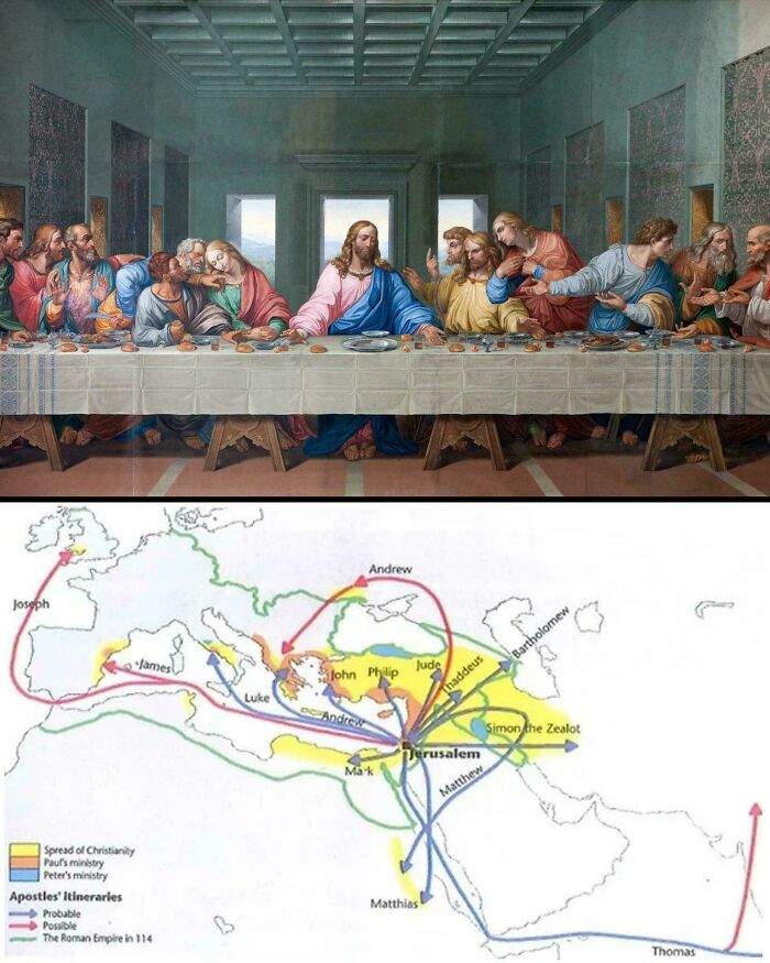
Image credits: Sad_Bug8421
Nowadays, every second kid has an iPad, they're caught up in the latest series or game, their parents use GPS and the world is hurtling towards a fully digital realm. So how do we keep children interested in maps? What do we do to ensure their survival?
"I think making it about them and their interests is key. Have a kid who loves dinosaurs, show them a map of Pangea," suggests Wright. "A kid who loves space, show them a map of the moon. A kid who loves Harry Potter show them a map of wizarding schools."
#19 Where Popes Were Born
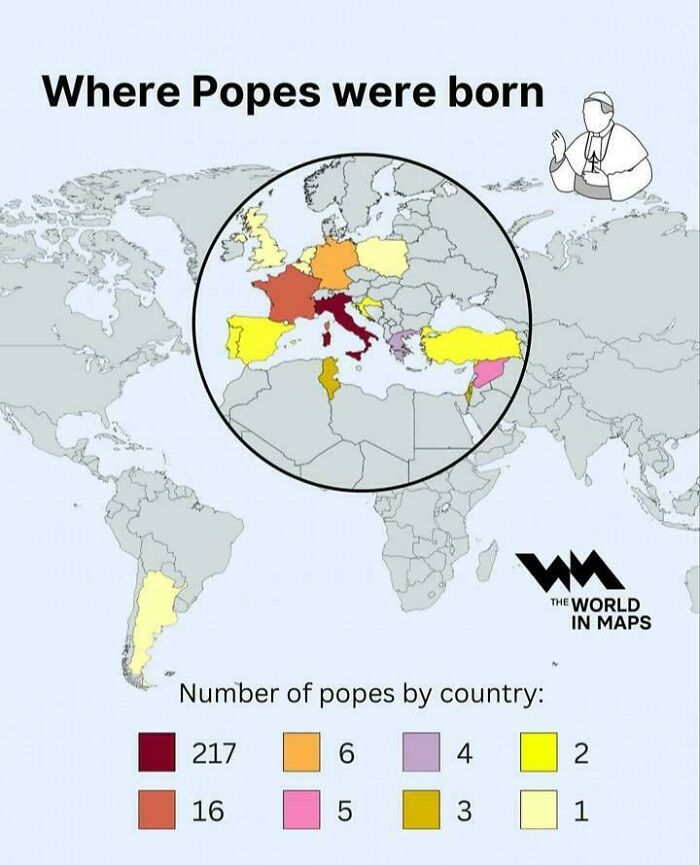
Image credits: YourFriendSin
#20 Countries Where More People Died Than Were Born During The Year 2024
Image credits: OppositeRock4217
#21 Size Comparison Of European Microstates
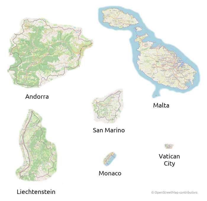
Image credits: Xhiw_
#22 Doctor’s That Can’t Refuse An Abortion In Europe
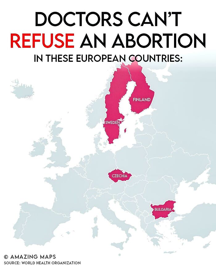
Image credits: LuckyTraveler88
#23 A British Propaganda Poster Against Russia From The 1800's
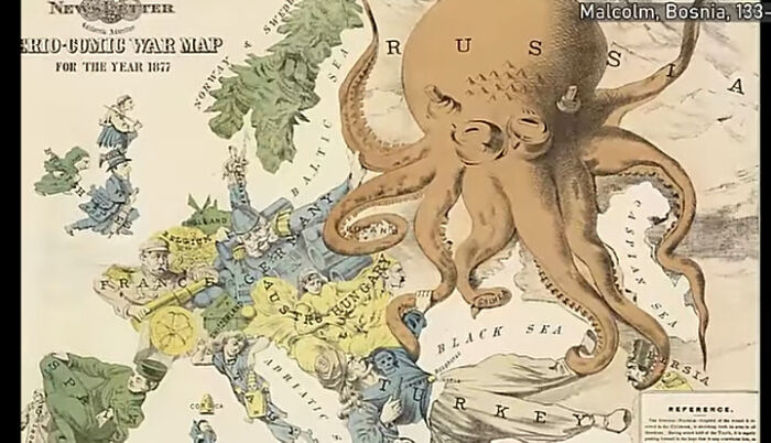
Image credits: monsterduckorgun
#24 How Many Cities Over 1 Million People Does Each Country Have?
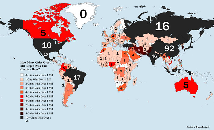
Image credits: Joergen-the-second
#25 Countries That Lost Forces Supporting U.S. Forces In Afghanistan
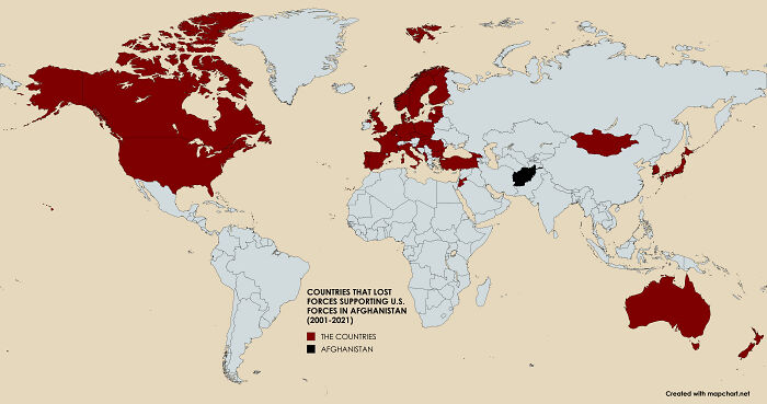
Image credits: Brilliant-Nerve12
#26 United States Counties Where Selling Of Alcohol Is Completely Prohibited
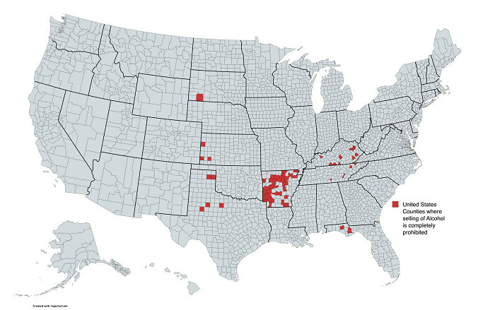
Image credits: dphayteeyl
#27 U.S. Counties Where Life Expectancy Is Below That Of North Korea
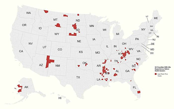
Image credits: BufordTeeJustice
#28 Area Of Nazi Germany Control On The Day Of Their Official Surrender
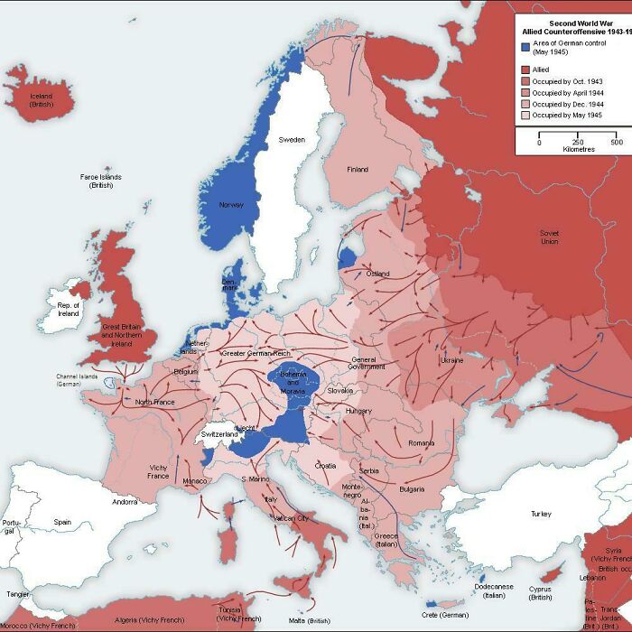
Image credits: marbellamarvel
#29 European Countries By The Exact Shade Of Blue In Their Flag
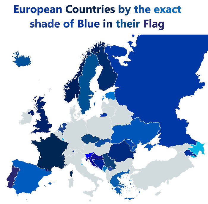
Image credits: xMusa24
#30 Second Largest Religion In European Countries
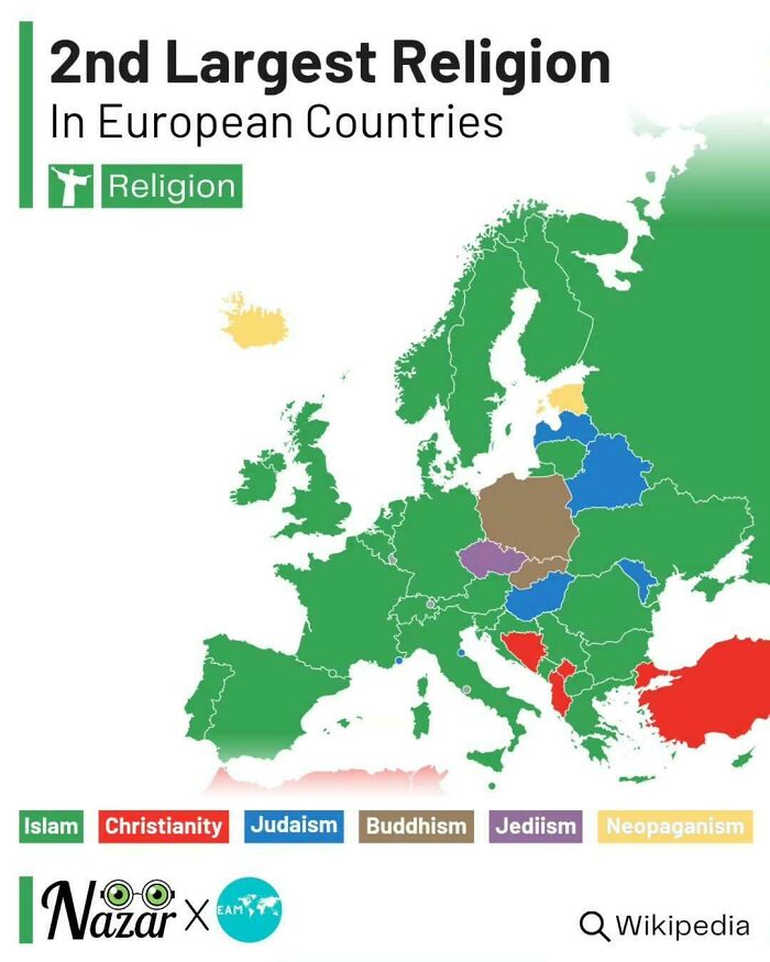
Image credits: vladgrinch
#31 Freedom Of Press Rankings In Europe

Image credits: LuckyTraveler88
#32 Christianity In The Us By County
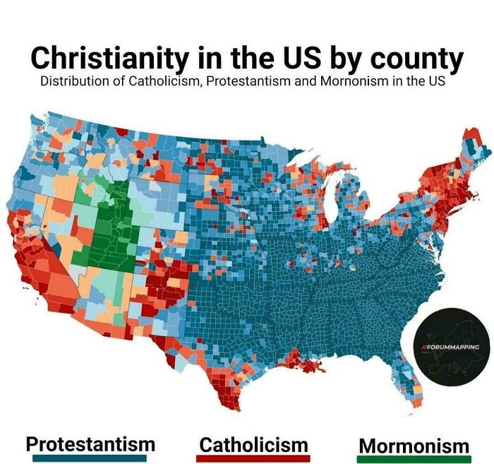
Image credits: zevalways
#33 Germany's Largest Immigrant Communities By Region
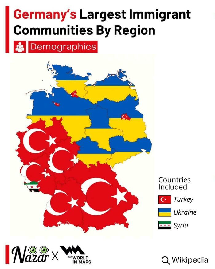
Image credits: vladgrinch
#34 Suicide Rates By Region In Italy
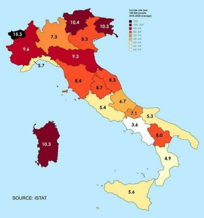
Image credits: vladgrinch
#35 Second Biggest Religion In Every Us State

Image credits: Few_Introduction9919
#36 Median Home Size In USA Compared To Parts Of Europe
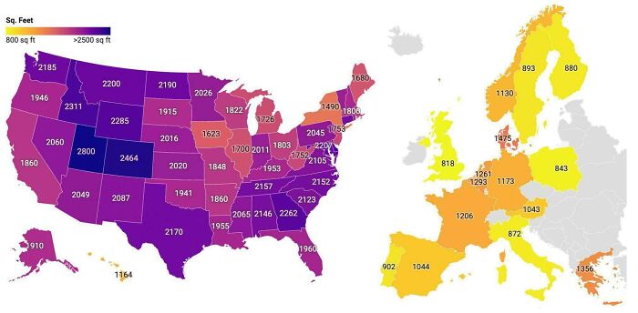
Image credits: BufordTeeJustice
#37 A Look At The Oldest Universities In Continuous Operation Across Europe
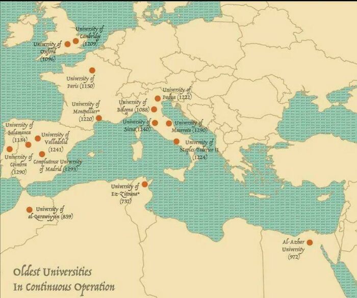
Image credits: marbellamarvel
#38 Country Names Compared To English
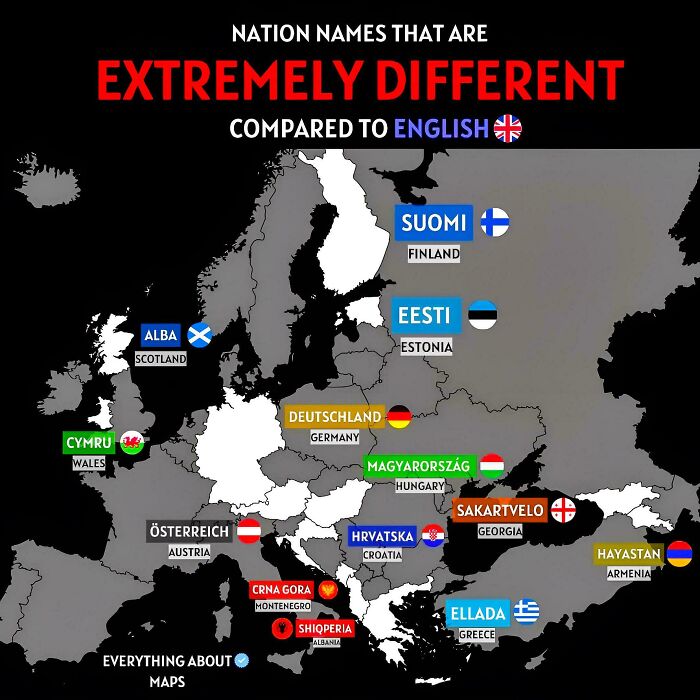
Image credits: LuckyTraveler88
#39 Currencies In Europe
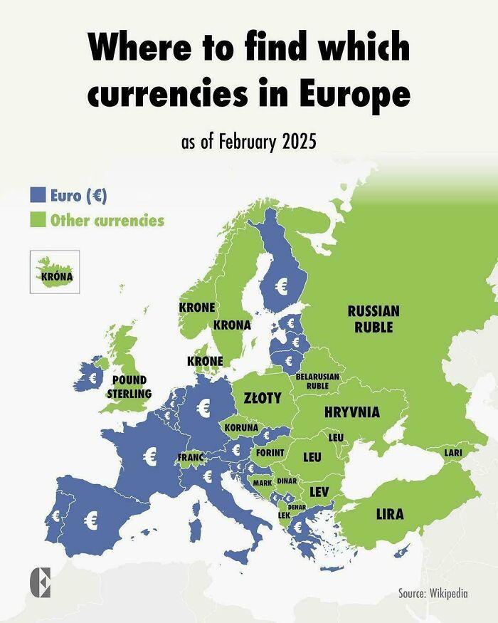
Image credits: throwitintheair22
#40 Deception Island Near Antarctica Have Such A Straight Eastern Coast?
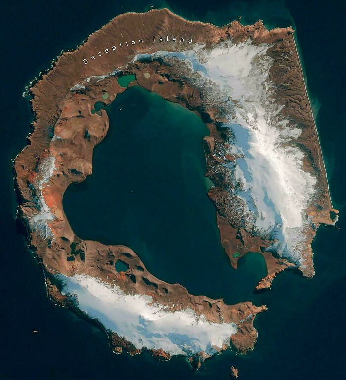
Image credits: marbellamarvel
#41 The Most Common Blood Types In Europe, By Country
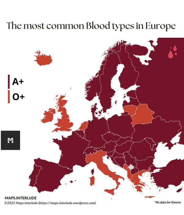
Image credits: quindiassomigli
#42 Homeowners That Lock Their Doors In The U.S
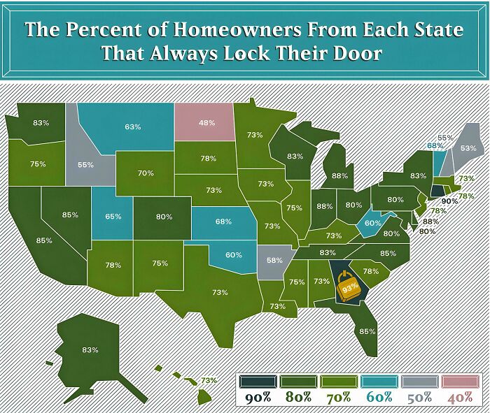
Image credits: LuckyTraveler88
#43 The Dictators Overtrown By The Arab Spring
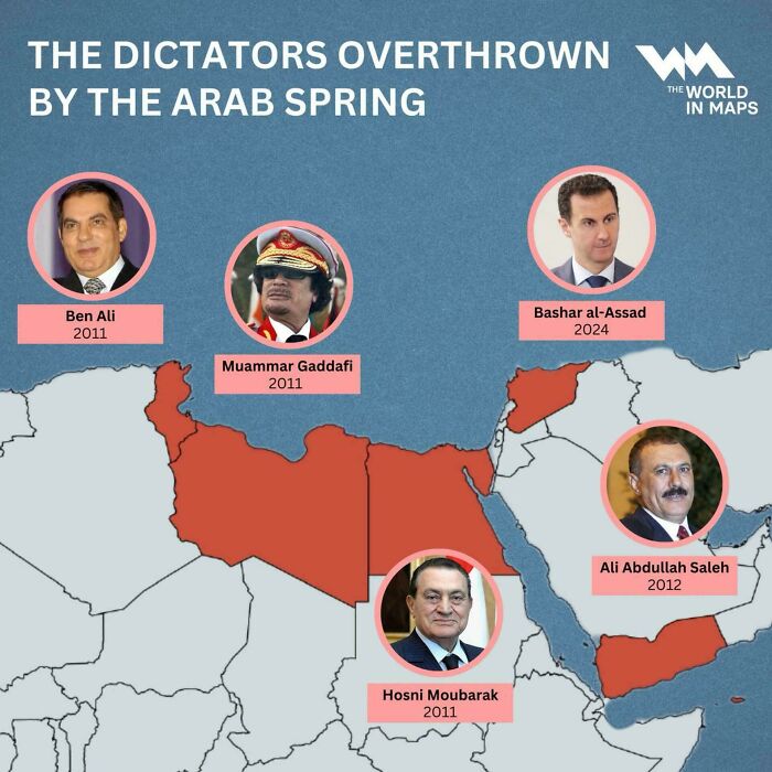
Image credits: Individual-Sun-9426
#44 Is It Legal To Drink Coffee While Driving?
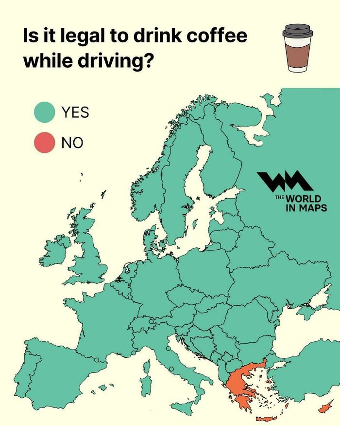
Image credits: vladgrinch
#45 Countries Adolf Hitler Visited
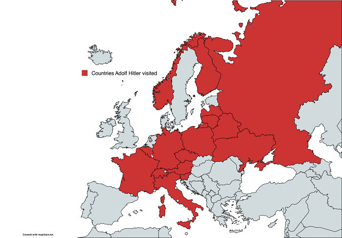
Image credits: dphayteeyl
#46 Billionaires By Citizenship
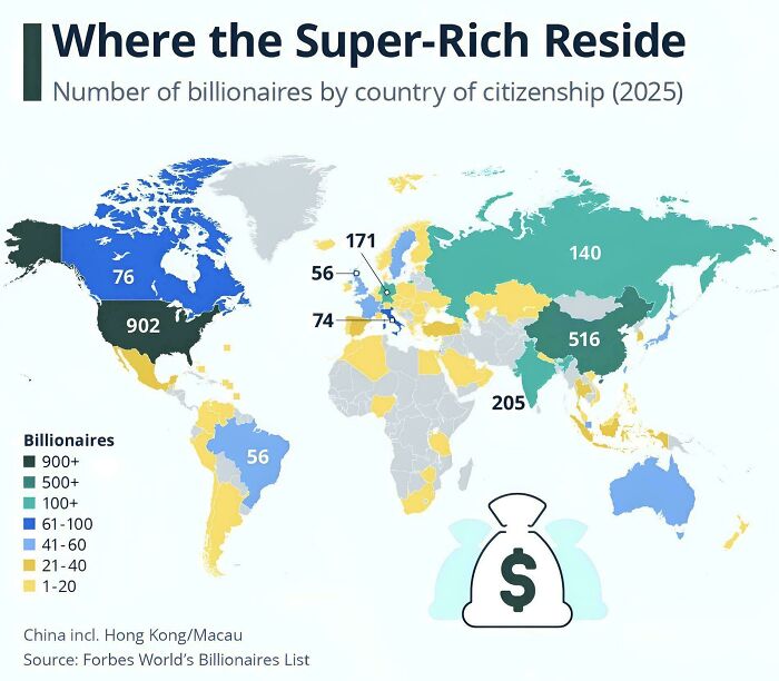
Image credits: LuckyTraveler88
#47 Here's Where Weed Is Legal In The Us
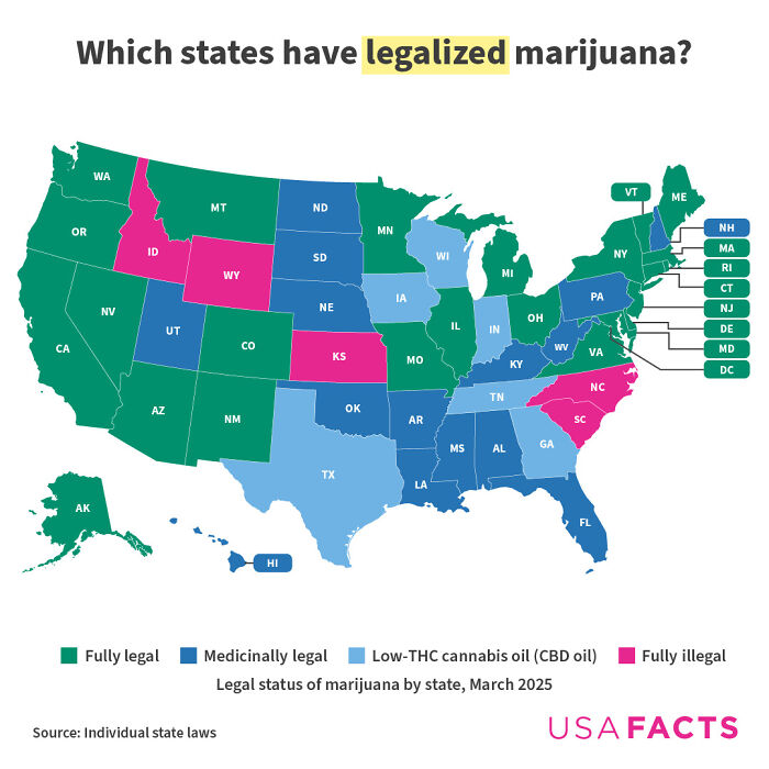
Image credits: USAFacts
#48 Which City (In Your Country) Are You Most Ashamed Of?
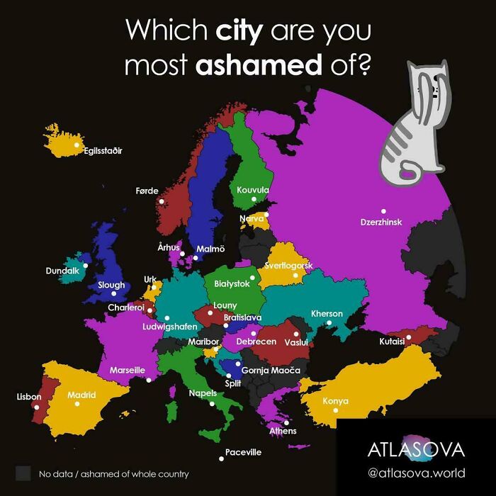
Image credits: SquareFroggo
#49 Religion And Literacy Rate In Nigeria
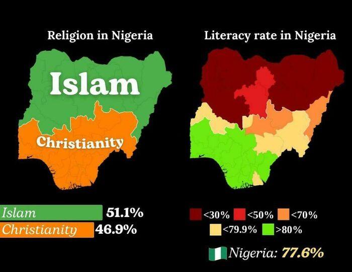
Image credits: ellatino230
#50 Us States With A Ban On Construction Of Nuclear Power Plants
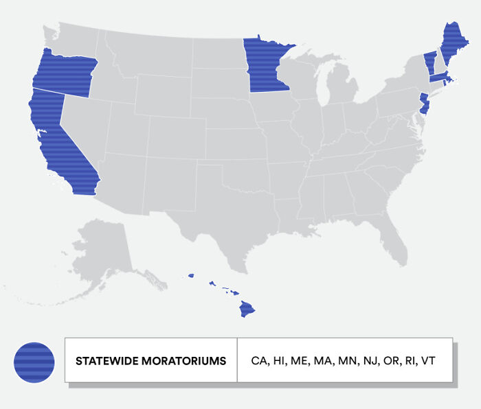
Image credits: IsleFoxale
#51 24 Hours Of Flights Between Europe And The Us
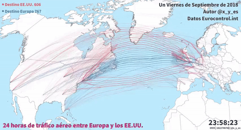
Image credits: vladgrinch
#52 Which Of The 10 Largest Cities By Population Is Closest To You?
Image credits: Organic_Product_2464
#53 Countries That Skip Labor Day (1st Of May)
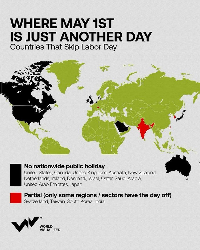
Image credits: vladgrinch
#54 If “Did Not Vote” Was A Party In The 2021 Canadian Federal Election
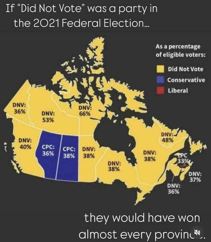
Image credits: manitoba94
#55 Drug Overdose Deaths Across Europe
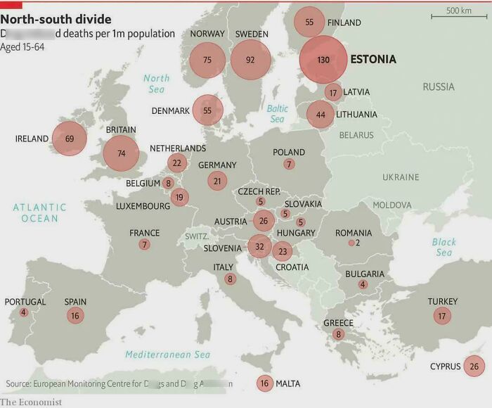
Image credits: Trustrup
#56 Use Of Dinner vs. Tea vs. Supper In The UK
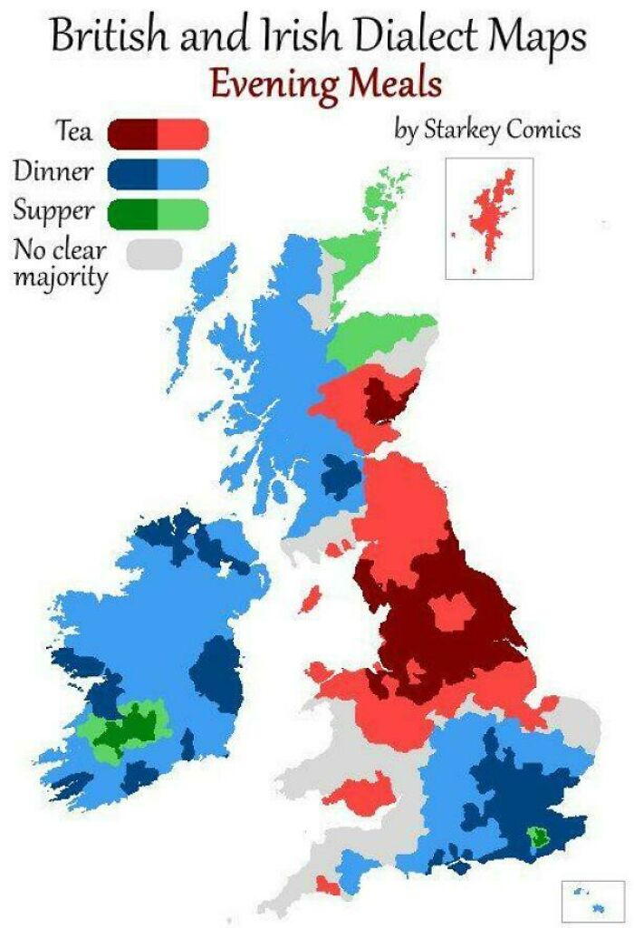
Image credits: vladgrinch
#57 The First Time Each European Country's Leader Took Office
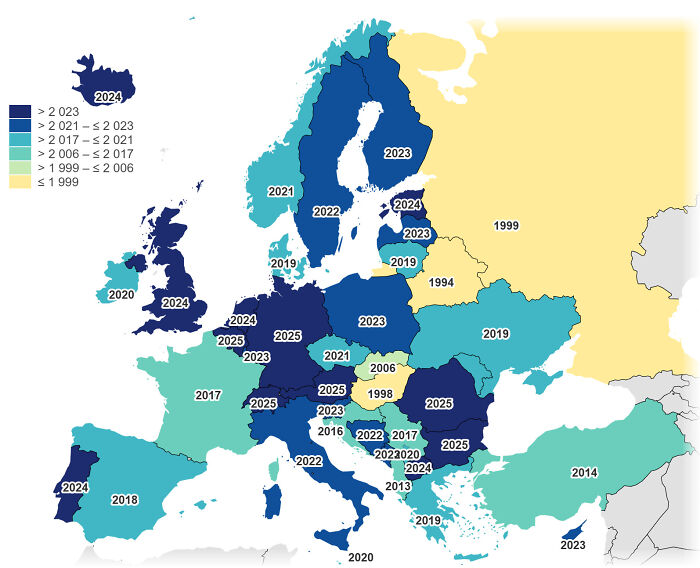
Image credits: Prudent_Comedian_479
#58 2024 Democracy Situation In Europe
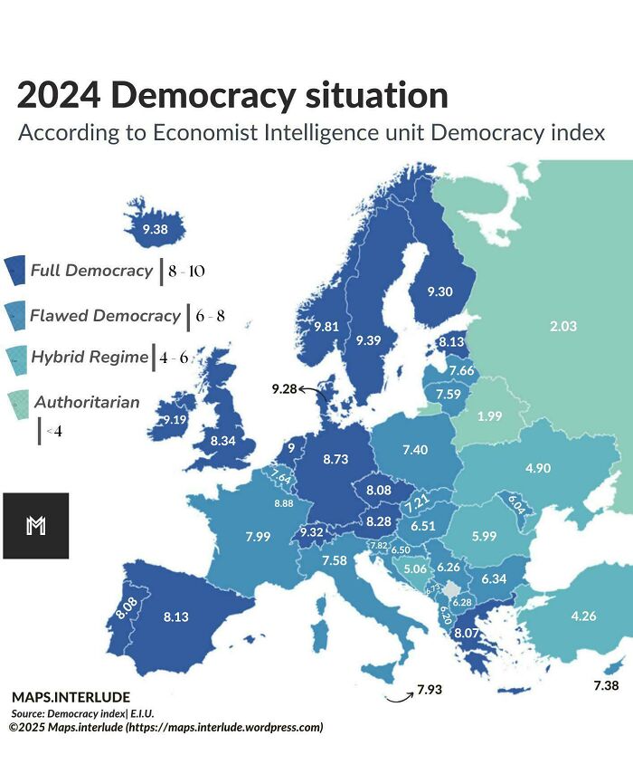
Image credits: quindiassomigli
#59 Where Easter Is A Public Holiday
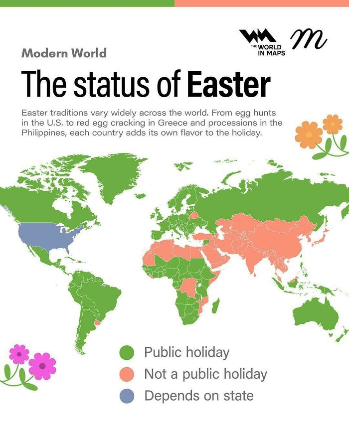
Image credits: AdIcy4323
#60 Where Good Friday Is A Public Holiday
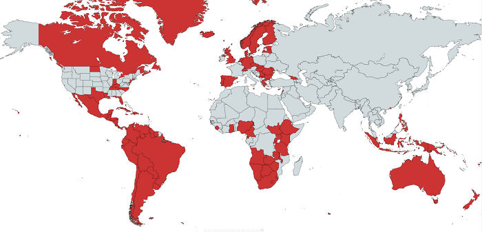
Image credits: OppositeRock4217
#61 Hawaii On The Same Scale As The U.k

Image credits: whiterafter
#62 Pastoral Visits Of Pope Francis
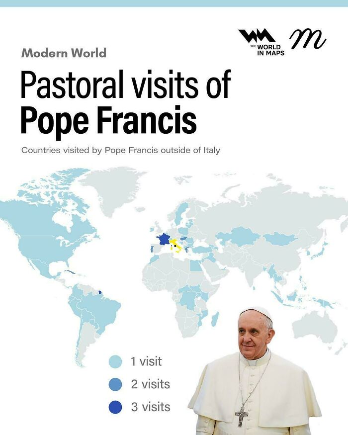
Image credits: AdIcy4323
#63 Israel Travel Advisory Map
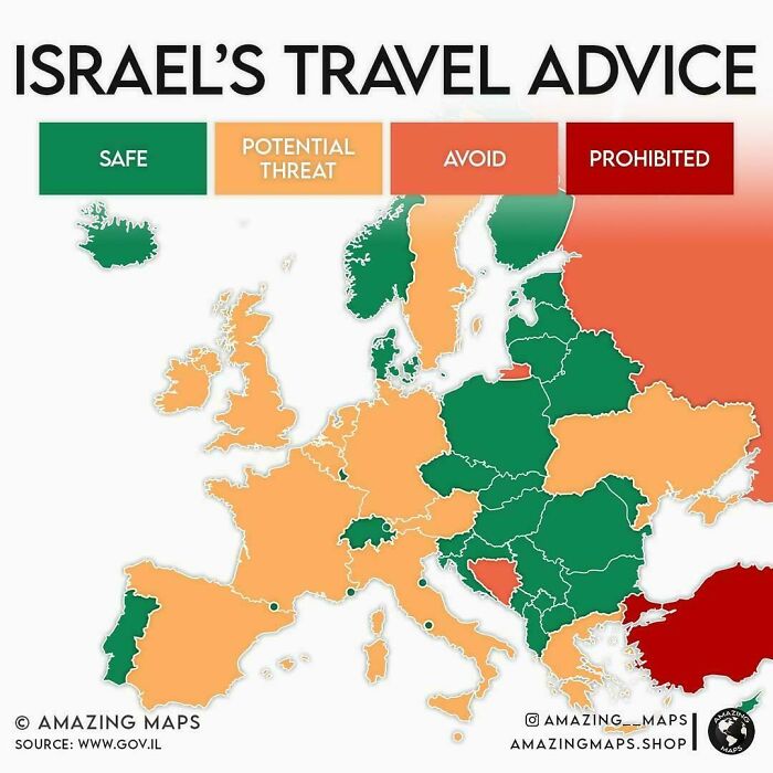
Image credits: AdIcy4323
#64 Eligible Electors By Region For The Next Pope
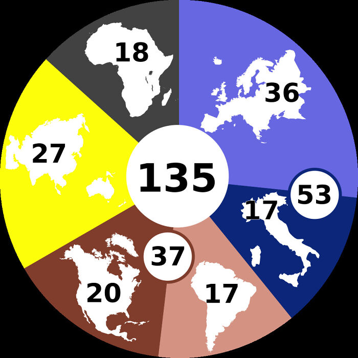
Image credits: APrimitiveMartian
#65 What Do You Call The Vehicle That Hauls Freight?
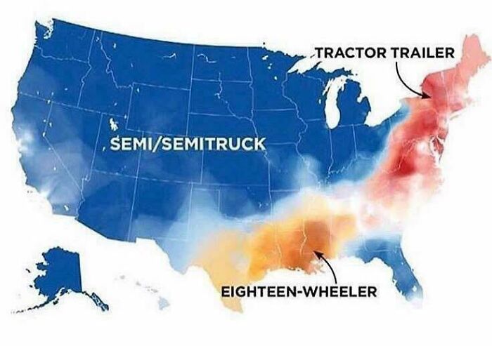
Image credits: PoopKing6969
#66 First 5 Countries To Recognize The U.S

Image credits: LuckyTraveler88
#67 Special Envoy Keith Kellogg Proposed To "Divide" Ukraine, Like Berlin After World War II
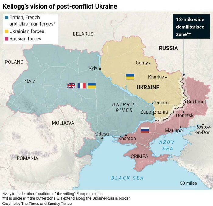
Image credits: TackleDry1732
#68 Poland At It’s Maximum Extent Compared To Its Borders Today
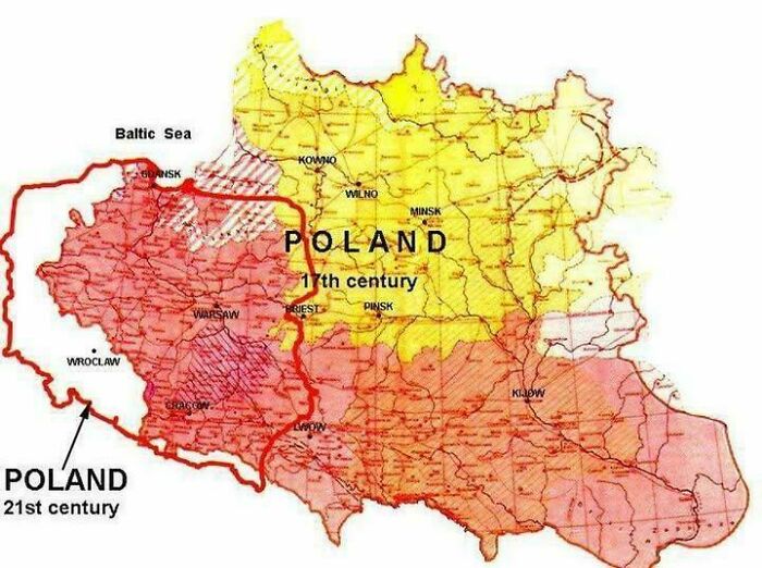
Image credits: vladgrinch
#69 Most Common Immigrant In Italy🇮🇹
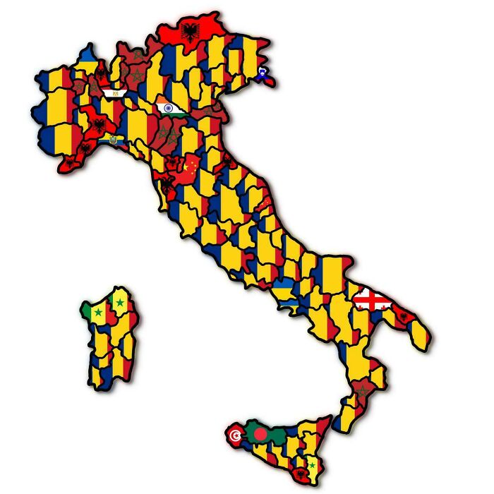
Image credits: Jaded_Landscape_6481
#70 Map Of Airstrike Locations By India
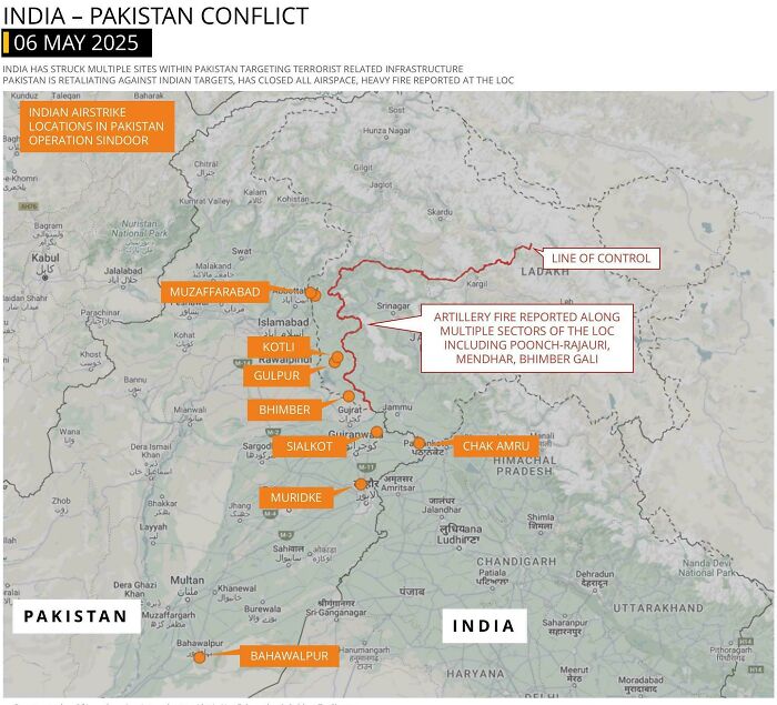
Image credits: multi_tasker01
#71 The World According To Apple Look Around (Apple Maps Street View)
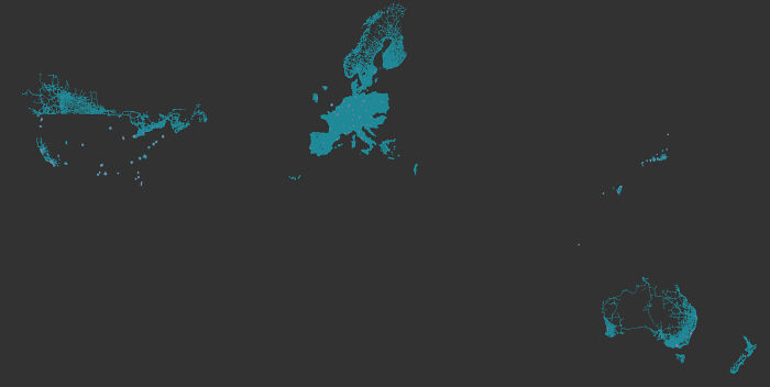
Image credits: lukstez
#72 Canadian Election Projections: January 2025 vs. The Actual Outcome
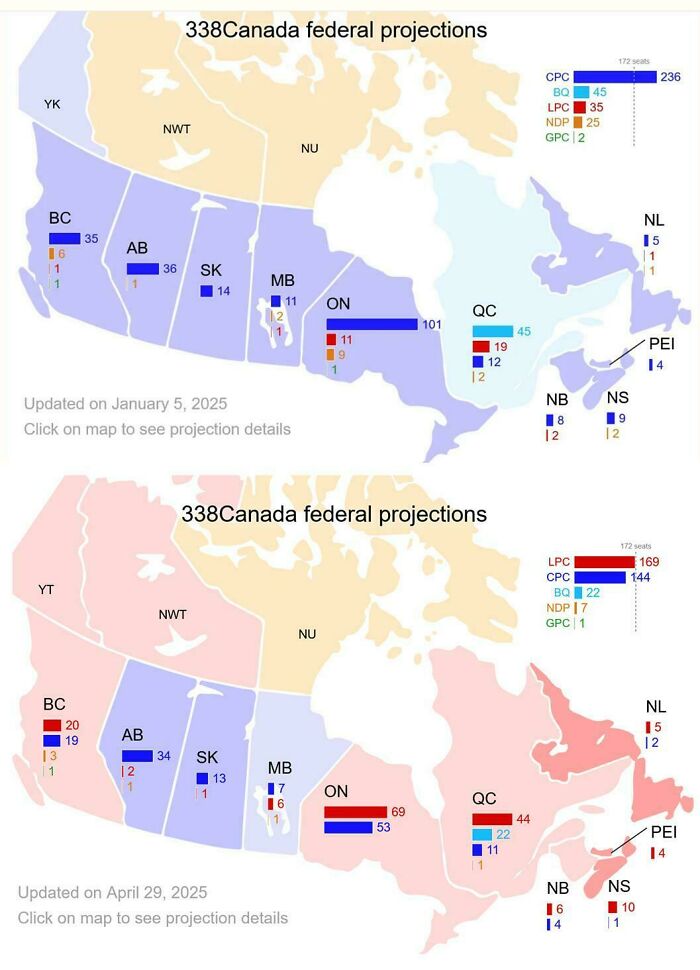
Image credits: CBowdidge
#73 USA Murder Rate By State
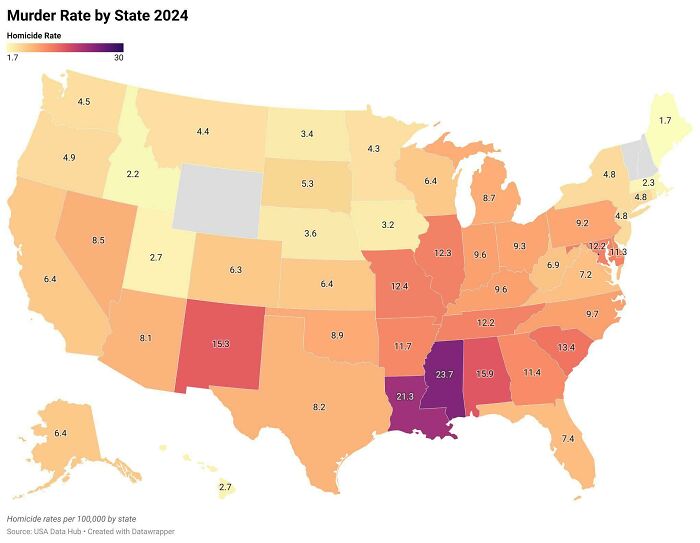
Image credits: Pale_Consideration87
#74 A 'Purple Map' Of The Us Presidential Elections, 2024
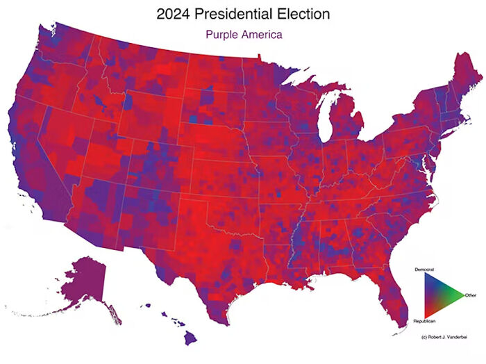
Image credits: yechengs
#75 New York's Top 10 Speeders And Where They Have Received Tickets
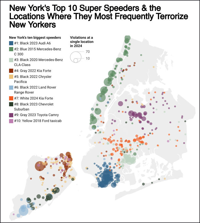
Image credits: Kooker321
#76 Update: States Where P**nhub Will Be Blocking Access As Of January 1, 2025
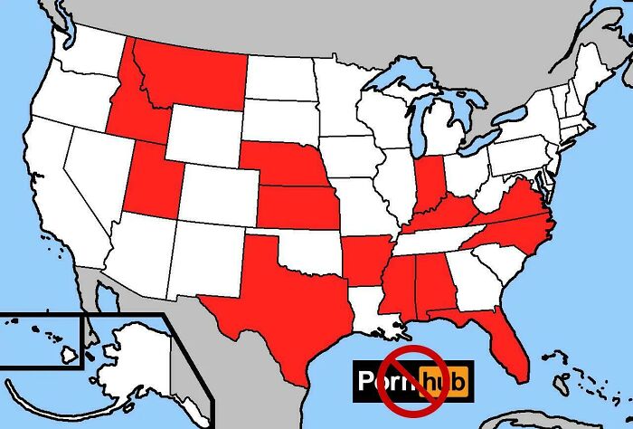
Image credits: DizzyDentist22
#77 How Every County Voted Over The Last 3 Elections
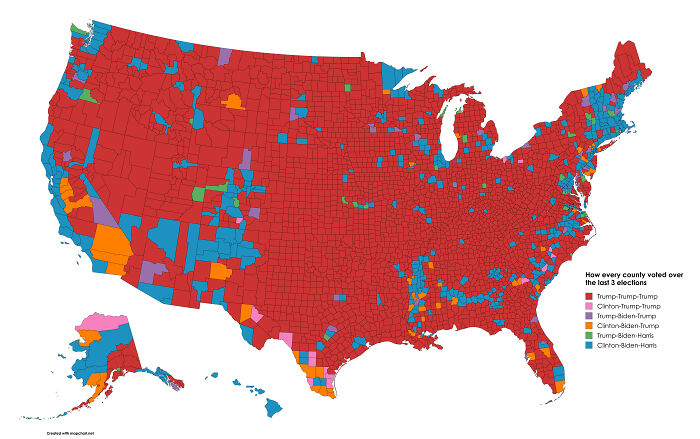
Image credits: Mission-Guidance4782
#78 1936 Election
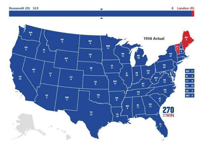
Image credits: TJ_DOG_likes_britons
#79 Last Time Each European Country Was Invaded And By Who
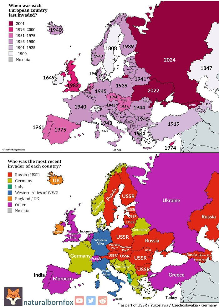
Image credits: vladgrinch
#80 Delmar Divide (St. Louis Mo)
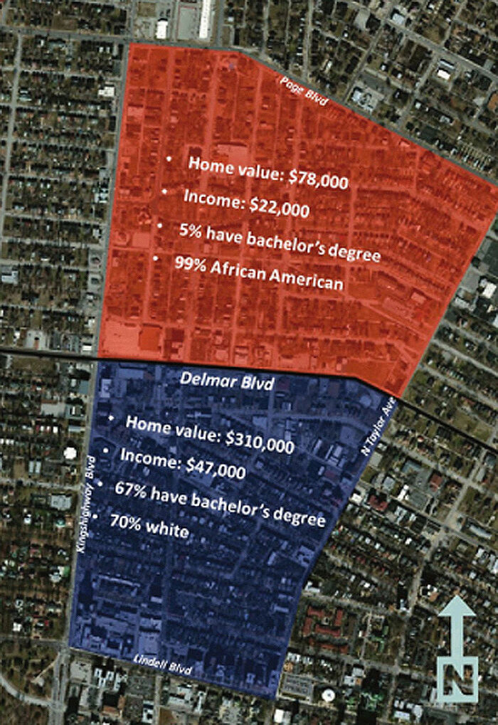
Image credits: DrDMango