What's the weather like in your area? Report the situation through Rappler's Agos or tweet us at @rapplerdotcom.
MANILA, Philippines – The number of areas under Signal No. 1 rose to two dozen on Thursday morning, September 13, as Typhoon Ompong (Mangkhut) slowed down over the Philippine Sea.
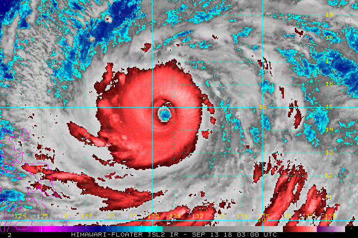
In a bulletin issued 11 am on Thursday, the Philippine Atmospheric, Geophysical, and Astronomical Services Administration (PAGASA) said Ompong is already 725 kilometers east of Virac, Catanduanes, moving west at a slower 20 kilometers per hour (km/h) from the previous 30 km/h.
The typhoon continues to have maximum winds of 205 km/h and gustiness of up to 255 km/h.
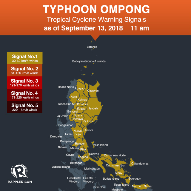
Signal No. 1 is now raised in:
- Batanes
- Cagayan including Babuyan Group of Islands
- Apayao
- Abra
- Kalinga
- Mountain Province
- Ifugao
- Isabela
- Benguet
- Quirino
- Aurora
- Nueva Vizcaya
- Nueva Ecija
- Bulacan
- Rizal
- Laguna
- Quezon including Polillo Island
- Camarines Norte
- Camarines Sur
- Catanduanes
- Albay
- Sorsogon
- Burias and Ticao islands
- Northern Samar
Those areas under Signal No. 1 are in the regions of Cagayan Valley, the Cordillera Administrative Region (CAR), Central Luzon, Calabarzon, Bicol, and Eastern Visayas. Occasional rains with gusty winds are expected within the next 36 hours.
PAGASA warned there may be heavy to intense rain, storm surges in coastal areas, and very strong winds in Cagayan Valley and CAR beginning Friday, September 14, and in Northern Luzon on Saturday, September 15. (READ: FAST FACTS: Tropical cyclones, rainfall advisories)
Ompong might make landfall in the northern tip of Cagayan on Saturday morning. (READ: Will Typhoon Ompong be the same as Super Typhoon Lawin?)
Fishermen and others with small sea vessels are advised not to venture out into the seaboards of areas under Signal No. 1, the northern seaboard of Northern Luzon, and the eastern seaboards of the Visayas and Mindanao.
Class suspensions have already been announced for the rest of the week. (READ: #WalangPasok: Class suspensions for September 13, 14, 15)

The typhoon is also enhancing the southwest monsoon or hanging habagat. The enhanced southwest monsoon could trigger moderate to heavy rain in the following areas:
- Friday - Palawan, Zamboanga Peninsula, Visayas, Metro Manila
- Saturday - Palawan, Zamboanga Peninsula, Western Visayas, Metro Manila
Residents of areas affected by the southwest monsoon should be on alert for flash floods and landslides, too.
Local government units, the Armed Forces of the Philippines, the Philippine National Police, and the Philippine Coast Guard were placed on alert to respond to the typhoon.
Ompong is the Philippines' 15th tropical cyclone for 2018. The country usually gets an average of 20 tropical cyclones per year. (READ: LIST: PAGASA's names for tropical cyclones in 2018)
PAGASA declared the start of the rainy season last June 8. – Rappler.com
News you can use during Typhoon Ompong (Mangkhut):
- Weather updates and storm signals
- Reports on evacuation, emergencies, and rescue and relief efforts
- Typhoon Ompong: Free parking at SM, Ayala, Robinsons, Megaworld malls
- #WalangPasok: Class suspensions for September 13, 14, 15
- Canceled flights due to Typhoon Ompong
- Will Typhoon Ompong be the same as Super Typhoon Lawin?
- What gov't has done so far to prepare for Typhoon Ompong
- Fact-check on viral stories related to Typhoon Ompong