Tropical storm Ophelia is expected to reach the coast of North Carolina on Friday night and bring high winds, coastal flooding and life-threatening rip currents northward to New Jersey over the weekend.
The National Hurricane Center has issued a tropical storm warning from Cape Fear, N.C., to Fenwick Island, Del. This includes Albemarle and Pamlico sounds in North Carolina, the Tidal Potomac River south of Cobb Island, Md., and Chesapeake Bay south of North Beach, Md. The region stretching from Surf City to Beaufort Inlet in North Carolina, and the remainder of Pamlico and Albemarle Sounds, were under a storm surge watch. A storm surge warning was also in effect from just north of Wilmington, N.C., to Chincoteague, Va., south of the Delaware line.
Between 3 to 5 inches of rainfall is expected across North Carolina and Virginia into Saturday, with as much as 7 inches falling in some areas. The Mid-Atlantic into southern New England, is forecast to get 2 to 4 inches of rainfall from late Friday into Sunday, which could create flash, urban and small stream flooding, forecasters said.
The swells generated by Ophelia are likely to cause life-threatening surf and rip current conditions across the Mid-Atlantic coastline.
Areas stretching from Surf City N.C., to Chincoteague, Va., could see flooding of 2 to 4 feet if the storm surge peaks along with high tide, forecasters said. Portions of the Outer Banks are expected to see floodwaters rise between 3 and 5 feet.
The surge could cause flooding of 2 to 4 feet in the lower Chesapeake Bay and 1 to 3 feet farther up the bay.
Floods are getting more frequent and severe in most of the U.S. because of more extreme precipitation and sea level rise from climate change.
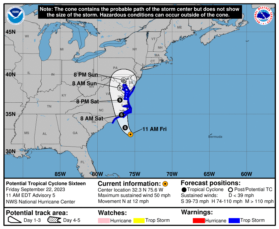
The storm picked up speed as it was upgraded on Friday afternoon from a "Potential Tropical Cyclone 16," as the NHC terms it, to a tropical storm. Ophelia was moving near 12 mph while about 150 miles southeast of Cape Fear.
As it continues plotting a northerly path, the NHC said the storm will move across eastern North Carolina, southeastern Virginia, and the Delmarva Peninsula on Saturday and Sunday.
On Friday afternoon, the storm was producing maximum sustained winds close to 60 mph with higher gusts, and some slight strengthening is possible before landfall, forecasters said.
A few tornadoes are possible Friday and Saturday in the mid-Atlantic states, the NHC said.
Forecasters don't expect the storm to turn into a hurricane.
North Carolina Gov. Roy Cooper and the state's department of public safety urged residents across eastern and central portions of the state to be prepared for tropical weather over the next couple of days. Warning of the potential for downed trees, power outages and flooding, the officials also encouraged people to stay tuned to the latest weather forecasts.
"As tropical weather is threatening our state again, we are reminded of the importance of being prepared by having a family emergency plan and kit," Gov. Cooper said in a statement Thursday.
North Carolina Emergency Management director Will Ray said the department is prepared to provide needed resources.