Weather satellites have spied two hurricanes currently swirling menacingly on either side of Florida.
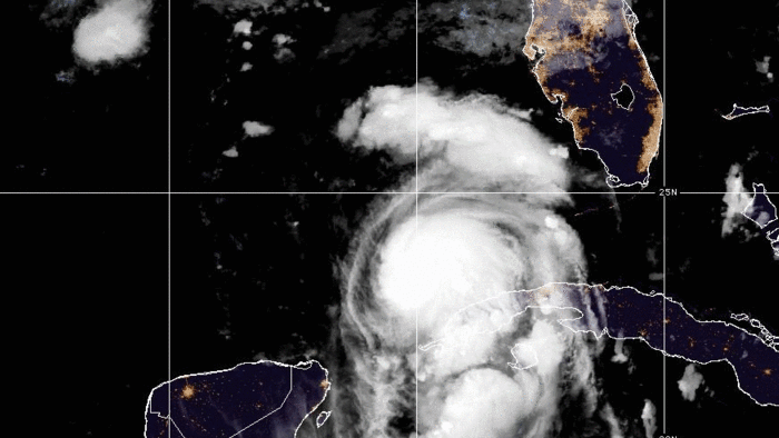
NOAA's GOES-East satellite captured views of Hurricanes Idalia and Franklin in the Gulf of Mexico and Atlantic Ocean, respectively, as seen from Monday to Tuesday (Aug. 28 to Aug 29). Footage from the satellites show both storms moving north as they swirl in a counter-clockwise motion due to the Coriolis Effect. In the time-lapse footage, Idalia can be seen transforming from a more nebulous storm into the characteristic spiral shape that hurricanes take.
Hurricane Idalia has already prompted school and airport closures on Florida's Gulf Coast as the region prepares for the storm to make landfall on Wednesday (Aug. 30). The storm is predicted to reach Category 3 before it reaches the Big Bend, the region where Florida's "panhandle" shape curves southward into the state's peninsula.
Related: Rocket Lab launches 2 NASA satellites to study tropical storms and hurricanes like never before
Idalia became a hurricane overnight. Here are 2 moonlit views via #NOAA20 and #NOAA21. The NHC expects Hurricane #Idalia to rapidly intensify over warm Gulf waters into an dangerous major hurricane before landfall and life-threatening storm surge on Florida early Wednesday. #FLwx pic.twitter.com/nuFJIlO34CAugust 29, 2023
As of 11 a.m. EDT (1500 GMT) on Tuesday, the United States National Hurricane Center (NHC) predicts that Hurricane Idalia could lead to "catastrophic impacts from storm surge" and "life-threatening" conditions along the Florida Gulf Coast. The center also predicts flooding throughout greater Florida, southern Georgia and the eastern Carolinas through Thursday (Aug. 31), with storm surge warnings in effect as far north as South Carolina.
Before it was even upgraded to a hurricane, the approaching storm prompted the delay of the upcoming Silent Barker/NROL-107 mission set to launch atop a United Launch Alliance Atlas V rocket from Cape Canaveral Space Force Station.
Astronauts aboard the International Space Station got a good look at Hurricane Idalia on Tuesday (Aug. 29) as the orbital lab was over the Gulf of Mexico.
Meanwhile, farther out in the Atlantic Ocean, Hurricane Franklin is expected to make its closest approach to the island territory of Bermuda on Wednesday (Aug. 30) Life-threatening surf and rip currents are predicted to occur on much of the East Coast of the United States throughout the week.
Hurricane Franklin is the first major Atlantic hurricane of the 2023 season. The storm is currently a Category 4 hurricane, according to the NHC.
Idalia, meanwhile, was just upgraded to hurricane status on Tuesday (Aug. 29) and is currently at Category 1.
Hurricane categories are based on a storm's sustained wind speeds. Category 1 storms feature winds between 74 and 95 mph (119 to 153 kph), Category 2 is 96 to 110 mph (154 to 177 kph), Category 3 is 111 to 129 mph (178 to 208 kph), Category 4 is 130 to 156 mph (209 to 251 kph), and Category 5 is 157 mph (252 kph) or above. Any storm at or above Category 3 is considered a major hurricane.