SpaceTech startup Fleet Space Technologies has launched a critical minerals exploration system that can deliver results up to hundred times faster than traditional methods.
Known as GeoSphere, the system integrates wireless hand deployable sensors with edge computing and low earth orbit nanosatellites. Its release today is a culmination of more than two years of development.
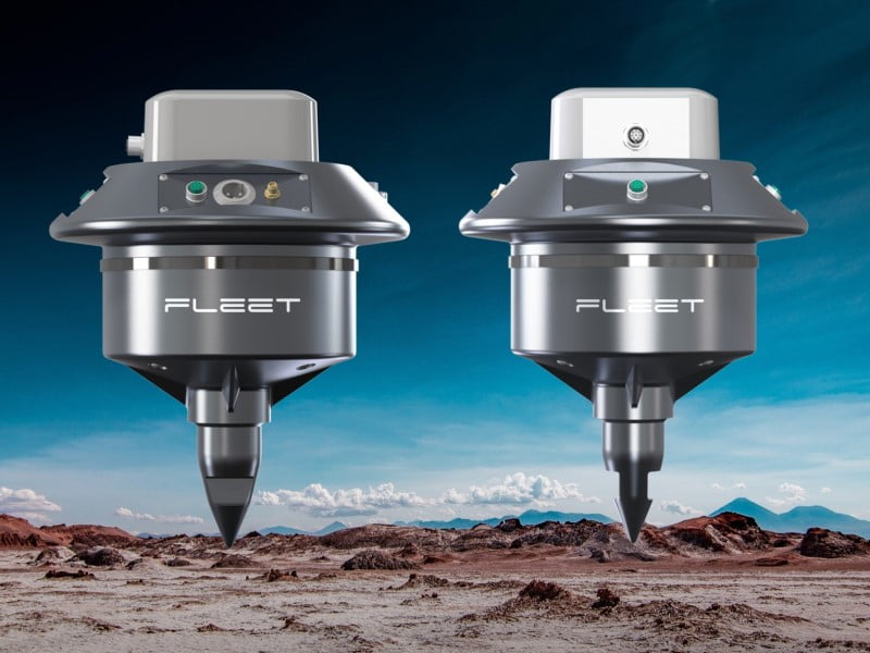
The wireless sensors, or Geodes, are fitted with a processing unit, satellite transmitter, and a seismic sensor. When installed in a 50 square kilometre grid, the Geodes can produce 3D visualisations of the subsurface in an area of up to 1000 square kilometres and depths of up to two kilometres.
Fleet Space Technologies co-founder and chief operating officer Matt Pearson said that GeoSphere system is an important tool to support the world’s shift towards green energy.
“The International Monetary Fund predicts that in just two decades more than US$13 trillion worth of the four major energy transition minerals must be mined to reach net zero ambitions. This requires more sustainable, faster and economically viable exploration practices,” Mr Pearson said.
“In GeoSphere, we have created the answer by unlocking the power of global connectivity through Fleet’s network of small satellites. They are already in operation in tandem with revolutionary non-invasive probes that rapidly scan beneath the earth to identify sources of these critical resources.
“We are proud to enable this critical step in mining to provide better access to the resources we need to make a better future for humanity.”
Fleet also highlights the environmental benefits of the technology as it replaces the need for damaging surveying equipment such as explosives, noise machines, and drilling.
The Geodes gather data about underground areas in a similar way that seismologists use the seismic waves produced by earthquakes through Ambient Noise Tomography (ANT). This involves the extraction of subsurface information by analysing ambient noise, which is the result of man-made seismic waves.
ANT data is then partially processed by the Geodes before being transmitted to ground stations via Fleet Space’s network of low-power small satellites. Further, using Fleet’s satellite network the visualisations can be accessed in real-time from anywhere in the world.
Processing the raw data at the point of collection, known as edge computing, reduces the data needed for transmission and thus increases the connection speed between Internet of Things devices.
The technology avoids the lengthy process of collecting the sensors, waiting for them to be shipped, and unpacked before the data can be accessed. Where other ANT systems may take 6-12 months before producing its final results, the images produced through GeoSphere can take as few as four days.
The Adelaide-based company launched its first satellite in 2018 and currently plans to launch its 3D printed Alpha satellites at the end of this year. This follows a successful US$26.4 million Series B capital funding round last November. Fleet also just opened its first international headquarters in Houston, Texas in February 2022.